Multi-source remote sensing big data collaborative resource management and environment monitoring method and application

A technology for environmental monitoring and resource management, applied in image data processing, measuring devices, instruments, etc., can solve problems such as not being a reliable guarantee for the water environment, not considering abnormal pixels, and the accuracy of monitoring results is not high, so as to change the display effect and methods, avoid human intervention, and reliably analyze the effect

Inactive Publication Date: 2021-10-08
南京中科智慧应急研究院有限公司
View PDF0 Cites 4 Cited by
  • Summary
  • Abstract
  • Description
  • Claims
  • Application Information

AI Technical Summary

Problems solved by technology

[0002] Traditional water environment monitoring in river basins mainly involves setting up fixed-point monitoring stations, sampling surveys, on-site observation and measurement. These monitoring methods and methods are conducive to accurately reflecting the local microscopic water body characteristics. If the water environment conditions of river basins are mapped macroscopically, Adopting such methods not only consumes manpower, material resources, and financial resources, but also is very inefficient.
[0003] With the continuous improvement of remote sensing technology and the continuous improvement of related theoretical models, remote sensing monitoring technology has been applied more and more in water environment monitoring. Since the remote sensing data of water environment monitoring are point cloud data, and these data need to go through a series of Complicated processing is required to obtain the data needed by people. However, a set of point cloud data is usually processed without considering the abnormal pixels in the original image data, so that the accuracy of the monitoring results is not high, and it cannot be used as a water environment monitoring tool. Reliable guarantee for later analysis, therefore, we propose a resource management and environmental monitoring method and application of multi-source remote sensing big data collaboration

Method used


Image

  • Multi-source remote sensing big data collaborative resource management and environment monitoring method and application

Examples


Embodiment

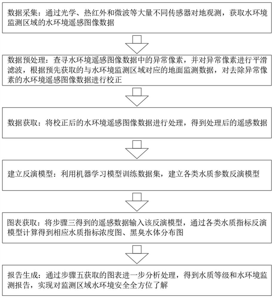
[0035] A multi-source remote sensing big data collaborative resource management and environmental monitoring method, comprising the following steps:

[0036] Step 1. Data collection: Observing the earth through a large number of different sensors such as optical, thermal infrared and microwave, to obtain remote sensing image data of the water environment in the water environment monitoring area, data collection, specifically including:

[0037] S1. The system uses oblique photography modeling software to process multiple initial image photos;

[0038] S2. Use the RTK measured control points to perform coordinate system registration on the image;

[0039] S3. The oblique photography software performs regional overall adjustment and multi-view image intensive matching on the image;

[0040] Step 2. Data preprocessing: search for abnormal pixels in the water environment remote sensing image data, and perform smoothing filtering on the abnormal pixels, according to the pre-acquir...


PUM


Abstract

The invention discloses a multi-source remote sensing big data collaborative resource management and environment monitoring method, which comprises the following steps of: obtaining water environment remote sensing image data of a water environment monitoring area through earth observation of different sensors; carrying out smooth filtering on the abnormal pixels, and correcting the water environment remote sensing image data from which the abnormal pixels are removed; processing the corrected water environment remote sensing image data to obtain remote sensing data; establishing various water quality parameter inversion models; inputting remote sensing data into the inversion model, and calculating through various water quality index inversion models to obtain a corresponding water quality index concentration diagram and a black and odorous water body distribution diagram; and further analyzing and processing through a chart to obtain a water quality grade and water environment monitoring report. The multi-source remote sensing big data collaborative resource management and environment monitoring method is efficient in data processing, high in monitoring result accuracy, capable of avoiding human intervention, reliable in analysis and capable of being widely applied to flood and lake environment resource monitoring and analysis processing.

Description

technical field [0001] The invention relates to the technical field of remote sensing monitoring, in particular to a resource management and environmental monitoring method and application of multi-source remote sensing big data collaboration. Background technique [0002] Traditional water environment monitoring in river basins mainly involves setting up fixed-point monitoring stations, sampling surveys, on-site observation and measurement. These monitoring methods and methods are conducive to accurately reflecting the local microscopic water body characteristics. If the water environment conditions of river basins are mapped macroscopically, Adopting such methods not only consumes manpower, material resources, and financial resources, but also is very inefficient. [0003] With the continuous improvement of remote sensing technology and the continuous improvement of related theoretical models, remote sensing monitoring technology has been applied more and more in water env...

Claims


Application Information

Patent Timeline
Patent Type & Authority Applications(China)
IPC IPC(8): G06T7/00G06T7/33G06N20/00G01D21/02
CPCG06T7/0002G06T7/33G06N20/00G01D21/02G06T2207/10032
Inventor 朱久荣张彧辰
Owner 南京中科智慧应急研究院有限公司
Why Eureka
Try Eureka