Unmanned aerial vehicle intelligent inspection system and inspection method based on 5G + Beidou

An intelligent inspection and drone technology, applied in control/regulation systems, non-electric variable control, instruments, etc., can solve the problems of large number of photos, time-consuming, slow data transmission speed, etc., and reduce network transmission delay , The effect of shortening data transmission time and improving image processing capability

Pending Publication Date: 2022-01-28
STATE GRID SHANDONG ELECTRIC POWER
View PDF3 Cites 0 Cited by
  • Summary
  • Abstract
  • Description
  • Claims
  • Application Information

AI Technical Summary

Problems solved by technology

Even skilled UAV pilots may blow up the aircraft due to operational errors
Moreover, the photos of drone inspections are stored in the memory card of the fuselage for a long time, and can only be exported and viewed after the operator completes the flight mission. However, data return through 4G, WiFi and other wireless communication technologies has long transmission time and Problems such as information leakage make it difficult to transmit data for UAV inspections.
In addition, the number of photos taken by drones is huge, and the retrieved photos need to be manually checked and compared one by one, which takes a lot of time, and subtle defects are easy to miss, and the analysis effect is highly dependent on the experience level of personnel, and the timeliness of problem discovery and processing is poor. Seriously restricting the improvement of the comprehensive efficiency of drone inspections
[0004] To sum up, the inventors found that the current UAV inspection is difficult to control, the speed of data transmission is slow, and the analysis of video images is not timely, resulting in the problems of low efficiency of UAV inspection and low accuracy of defect identification.

Method used


Image

  • Unmanned aerial vehicle intelligent inspection system and inspection method based on 5G + Beidou
  • Unmanned aerial vehicle intelligent inspection system and inspection method based on 5G + Beidou

Examples


Embodiment 1

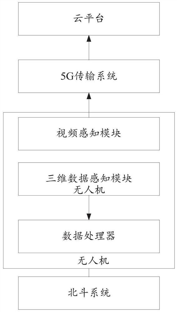
[0045] refer to figure 1 , this embodiment provides a 5G+Beidou-based UAV intelligent inspection system, which includes a data perception system, a data processor, a 5G transmission system, and a cloud platform; the data perception system, data processor, and 5G transmission system are all carried on the drone; the data perception system includes a three-dimensional data perception module and a video perception module.

[0046] In this embodiment, the three-dimensional data sensing module is used to sense the three-dimensional data of the transmission line corridor and transmit it to the data processor.

[0047] Wherein, the three-dimensional data sensing module is a three-dimensional laser scanning device. 3D laser scanning equipment is mainly composed of 3D laser scanner, computer, power supply system, bracket and system supporting software. As the main component of the 3D laser scanning system, the 3D laser scanning equipment is composed of a laser emitter, a receiver, a ...

specific Embodiment approach

[0052] As a specific implementation manner, the positioning process of the preset hovering position is as follows:

[0053] Based on the current geographic location of the drone and the preset hovering geographic location, the actual flight path of the drone is determined from the calibrated flight path of the drone;

[0054] On the actual flight route of the UAV, the position of the UAV is corrected in real time based on the Beidou system, and the real-time and accurate position of the UAV is determined to accurately reach the preset hovering position.

[0055] Among them, the process of real-time correction of the position of the UAV based on the Beidou system is as follows:

[0056] The drone sends its approximate location to the Beidou system;

[0057] The Beidou system selects three reference stations around the UAV, and virtualizes a reference station near the UAV based on a known pre-built correction model, and sends the data of the virtual reference station to the UAV...

Embodiment 2

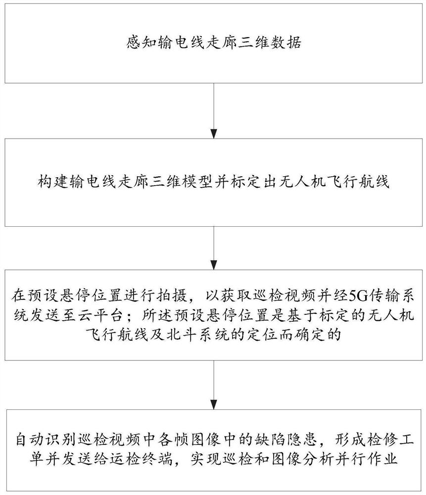
[0069] refer to figure 2 , this embodiment provides a 5G+Beidou-based intelligent inspection method for UAVs, which specifically includes the following steps:

[0070] Step 1: Perceive the three-dimensional data of the transmission line corridor;

[0071] Step 2: Construct a 3D model of the transmission line corridor and calibrate the flight path of the UAV;

[0072] Step 3: Shoot at the preset hovering position to obtain the inspection video and send it to the cloud platform through the 5G transmission system; the preset hovering position is determined based on the calibrated UAV flight route and the positioning of the Beidou system of.

[0073] In a specific implementation, the positioning process of the preset hovering position is:

[0074] Based on the current geographic location of the drone and the preset hovering geographic location, the actual flight path of the drone is determined from the calibrated flight path of the drone;

[0075] On the actual flight route o...


PUM


Abstract

The invention belongs to the field of unmanned aerial vehicle inspection, and particularly relates to an unmanned aerial vehicle intelligent inspection system and method based on 5G + Beidou. The system comprises a data sensing system, a data processor, a 5G transmission system and a cloud platform; the data sensing system comprises a three-dimensional data sensing module and a video sensing module; the three-dimensional data sensing module is used for sensing three-dimensional data of a power transmission line corridor and transmitting the data to the data processor; the data processor is used for constructing a power transmission line corridor three-dimensional model and calibrating a flight route of the unmanned aerial vehicle; the video sensing module is used for shooting at a preset hovering position so as to obtain an inspection video and send the inspection video to the cloud platform through the 5G transmission system; the preset hovering position is determined based on the calibrated flight route of the unmanned aerial vehicle and positioning of the Beidou system; and the cloud platform is used for automatically identifying defect hidden dangers in each frame of image in the inspection video, forming an inspection work order and sending the inspection work order to the operation inspection terminal, thereby realizing parallel operation of inspection and image analysis.

Description

technical field [0001] The invention belongs to the field of unmanned aerial vehicle inspection, and in particular relates to an intelligent inspection system and inspection method for an unmanned aerial vehicle based on 5G + Beidou. Background technique [0002] The statements in this section merely provide background information related to the present invention and do not necessarily constitute prior art. [0003] At present, the UAV line inspection is mainly to manually control the UAV, and the human operator must master proficient skills, otherwise it is difficult for unskilled people to control the UAV flight. The drone inspection work needs to shoot the details of the towers and lines, and the operator needs to control the drones to approach the towers and lines at close range, which requires high levels of operator skills and operational accuracy. Even skilled drone pilots may blow up the aircraft due to operational errors. Moreover, the photos of drone inspections ...

Claims


Application Information

Patent Timeline
Patent Type & Authority Applications(China)
IPC IPC(8): G05D1/10
CPCG05D1/106
Inventor 辛雨航曲增彬李坤孟建吕庆真程辉侯路吴珺韩然
Owner STATE GRID SHANDONG ELECTRIC POWER
Why Eureka
Try Eureka