Electromagnetic environment visualization method based on complex terrain

A technology of electromagnetic environment and complex terrain, applied in 3D image processing, instruments, calculations, etc., can solve the problems of considering the influence factors of complex terrain, electromagnetic propagation loss of parameter extraction, inability to realize visual rendering, etc., to achieve automatic visualization rendering, Rendered results with realistic, pastel-colored effects

Active Publication Date: 2022-05-31
南京超达信息科技有限公司
View PDF8 Cites 2 Cited by
  • Summary
  • Abstract
  • Description
  • Claims
  • Application Information

AI Technical Summary

Problems solved by technology

[0003] The electromagnetic environment visualization method based on complex terrain proposed in the existing simulation system has problems: (1) It only displays electromagnetic field strength data in combination with complex terrain, and does not consider the influence factors of complex terrain in the prediction and generation of electromagnetic field strength data
However, the generation process of the electromagnetic field intensity data of the spatial section does not take into account the factors of complex terrain, but only visualizes the electromagnetic field intensity data in complex terrain
For another example, the "electromagnetic visualization method and device (CN112528508)" proposed by Cai Jin et al. only connects the topography map and the electromagnetic radiation distribution map with the geographic information database, so as to realize the display of each electromagnetic radiation source in each constellation system. (2) In the electromagnetic simulation platform, the simulation calculation of the electromagnetic environment can only simulate the influence of complex terrain on electromagnetic propagation by manually inputting various parameters, and cannot be dynamically and automatically performed according to the specific terrain features Parameter extraction and calculation of electromagnetic propagation loss
[0004] Some electromagnetic environment visualization technologies based on three-dimensional space proposed in the existing simulation system have problems: automatic visual rendering cannot be realized; The electromagnetic environment volume data is divided into tetrahedral structures, and visualization is realized by constructing electromagnetic environment multi-isosurfaces

Method used


Image

  • Electromagnetic environment visualization method based on complex terrain
  • Electromagnetic environment visualization method based on complex terrain
  • Electromagnetic environment visualization method based on complex terrain

Examples


Embodiment

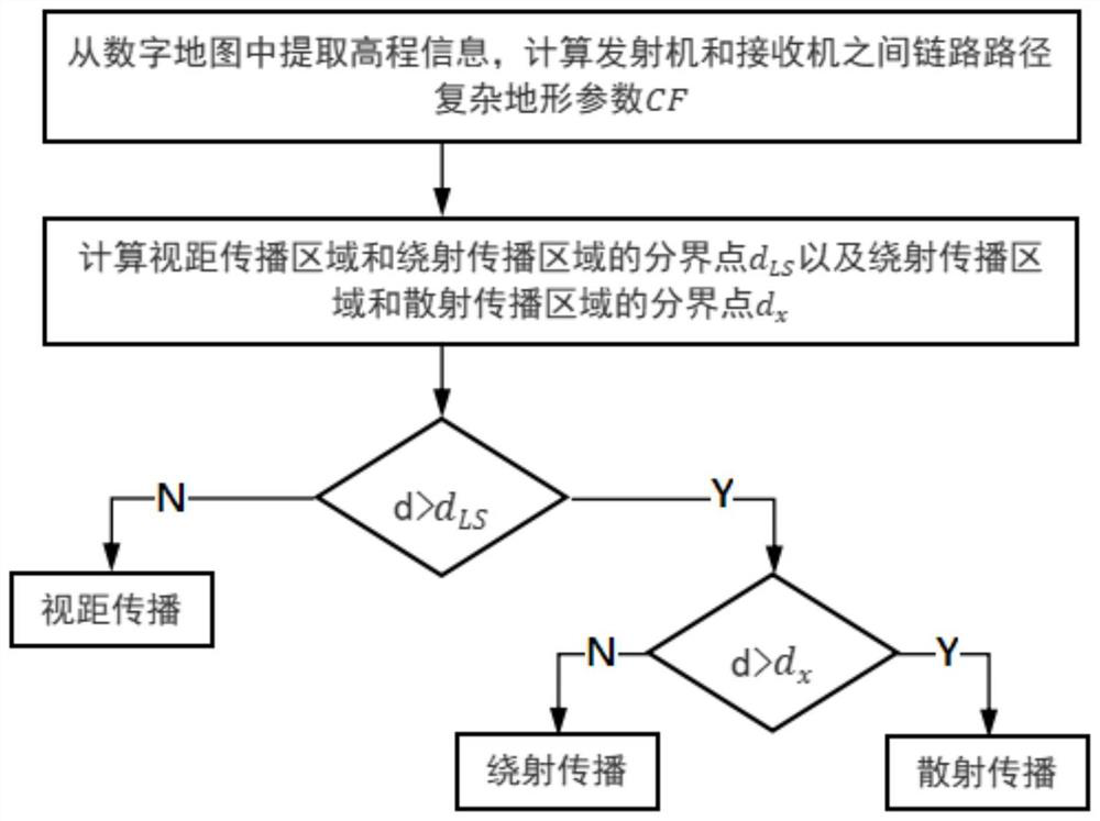
[0067] Example: as figure 1 As shown, the electromagnetic environment visualization method based on complex terrain specifically includes the following steps:

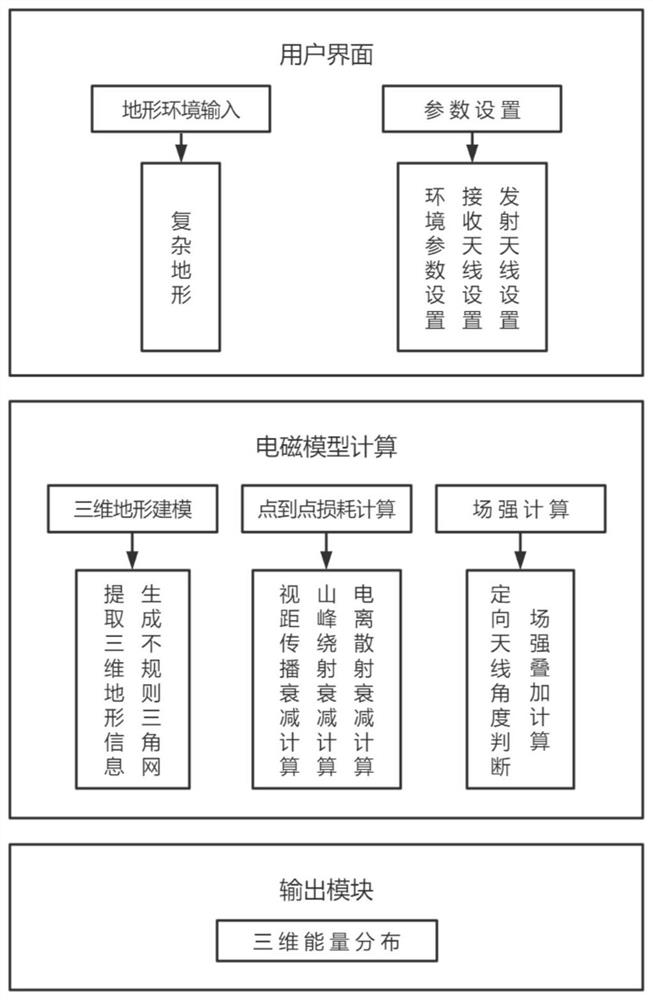
[0068] S1 Complex 3D Terrain Modeling: Construct an elevation model by processing geographic data to realize 3D modeling and rendering of complex terrain; 3D modeling of complex terrain is the premise of electromagnetic environment simulation and visualization, and it is the realization of geographic location and complex terrain in complex terrain. Accurate extraction of elevation values, calculation of parameters required for electromagnetic propagation model calculations, and further basis for performing 3D visualization;

[0069] The specific steps of complex three-dimensional terrain modeling in step S1 include:

[0070] S11: extract map data and convert map data into raster data; complex terrain is usually expressed by digital elevation model (DEM) of map data; the main terrain accuracy includes SRTM1 with 30m ac...


PUM


Abstract

The invention discloses an electromagnetic environment visualization method based on a complex terrain, and the method specifically comprises the following steps: S1, complex three-dimensional terrain modeling: carrying out the processing of geographic data, building an elevation model, and achieving the three-dimensional modeling and rendering of the complex terrain; s2, field intensity calculation based on a complex terrain model: performing field intensity comprehensive calculation by utilizing geographic position information and parameters obtained by interaction with a user to realize distribution and situation prediction of an electromagnetic environment; s3, visualizing the electromagnetic environment based on a three-dimensional color band rendering method: designing the three-dimensional color band rendering method based on visible light three-waveband control through an improved one-dimensional color band rendering mode; a volume rendering method is adopted for three-dimensional visualization of electromagnetic energy information, and three-dimensional visualization of the electromagnetic environment is achieved. According to the electromagnetic environment visualization method based on the complex terrain, calculated electromagnetic situation distribution can be more accurate, automatic visualization rendering of the electromagnetic environment is achieved, and the rendering result is vivid, soft in color and richer in expressive force.

Description

technical field [0001] The invention relates to the technical field of electromagnetic environment, in particular to a method and system for visualizing electromagnetic environment in complex terrain. Background technique [0002] With the rapid development of mobile wireless communication technology and applications, the electromagnetic environment becomes more and more complex. Under complex terrain conditions, the propagation of electromagnetic waves is affected by various factors such as terrain, vegetation, climate, etc., resulting in signal delay diffusion and multipath fading effects, which will seriously reduce the communication quality of mobile communication systems. The study of complex electromagnetic environment under complex terrain is particularly important for mobile communication networks, which is related to the level of network construction costs and the quality of network communication. Three-dimensional visualization of the electromagnetic environment i...

Claims


Application Information

Patent Timeline
Patent Type & Authority Applications(China)
IPC IPC(8): G06T17/05G06T17/20G06T15/00
CPCG06T17/05G06T17/20G06T15/005
Inventor 何向东张海涛宋锐刘晋源
Owner 南京超达信息科技有限公司
Why Eureka
Try Eureka