Medium-and-long-term dynamic landform evolution numerical simulation method for mountain stream strong tide estuary bifurcated section

A medium-to-long-term, mountain-stream technology, applied in the field of long-term dynamic landform evolution numerical simulation, which can solve the problems of large differences in flood and dry flow, large subjective influence of operators, and low generalization efficiency.

Active Publication Date: 2022-06-03
NANJING HYDRAULIC RES INST
View PDF9 Cites 0 Cited by
  • Summary
  • Abstract
  • Description
  • Claims
  • Application Information

AI Technical Summary

Problems solved by technology
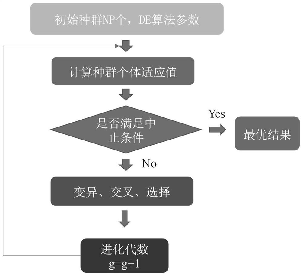
In the past, most of the generalization was manual, the generalization efficiency was low, and it was greatly affected by the operator's subjective influence, so the reference value was not great
In addition, in the traditional medium and long-term dynamic landform simulation method, the MF value method adopts a fixed shape multiplication factor
Due to the large difference between the flood and dry flow of typical mountain streams (for example, the Oujiang River flow rate can reach up to 2000), and the flood peak rises and falls sharply, the conventional fixed MF and average flow generalization cannot reflect the difference between the flood and dry conditions of mountain streams. How to correctly reflect the characteristics of mountain stream runoff and strong tides is the key issue for the accuracy of dynamic landform evolution simulation

Method used


Image

  • Medium-and-long-term dynamic landform evolution numerical simulation method for mountain stream strong tide estuary bifurcated section
  • Medium-and-long-term dynamic landform evolution numerical simulation method for mountain stream strong tide estuary bifurcated section
  • Medium-and-long-term dynamic landform evolution numerical simulation method for mountain stream strong tide estuary bifurcated section

Examples


Embodiment 1

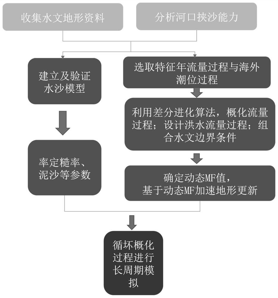
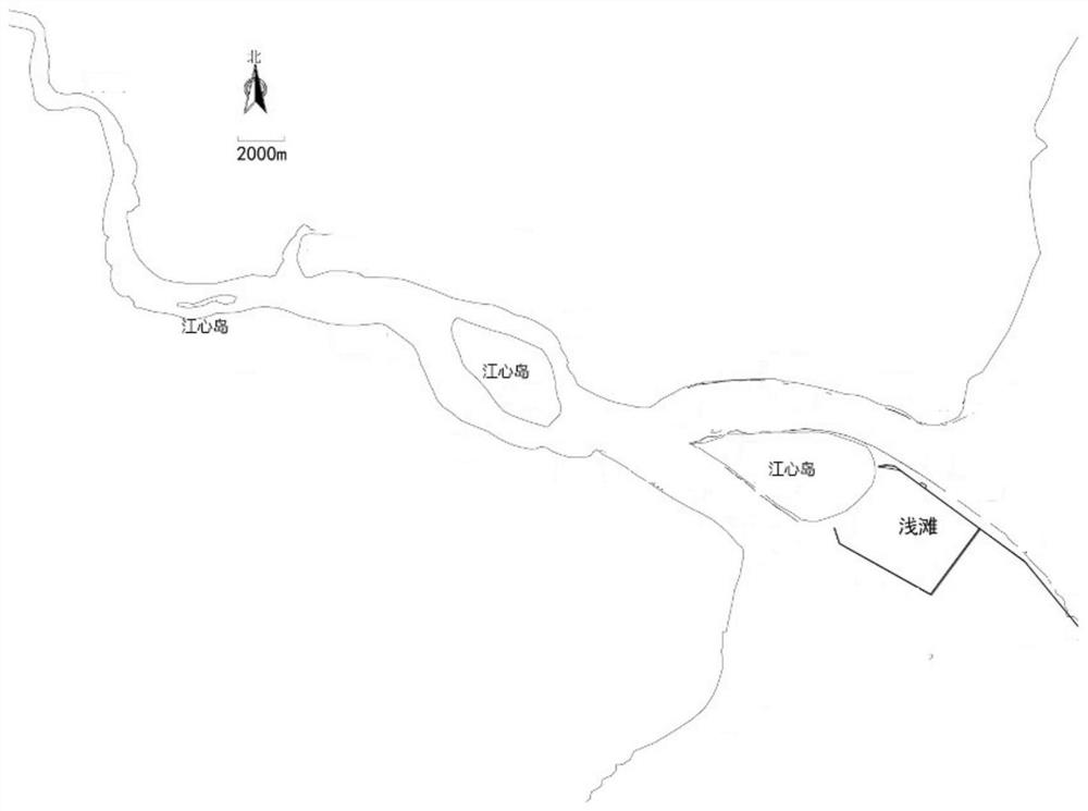
[0058] The Oujiang River is a mountain-stream tidal river, with short source and rapid flow, sudden rise and fall of flood peaks, large peak volume and short duration. The measured maximum flood peak flow is 22800m. 3 / s, minimum flow 10.6m 3 / s, the ratio of flood to dry water is 2,000 times. At the same time, the tide in the Wenzhou Bay area is a regular semi-diurnal tide, and the phenomenon of tidal height variation is more obvious. The tidal range in this area is large, and the average tidal range is more than 4m. It is one of the significant strong tidal areas in my country. Now take the Oujiang reach as an example to illustrate the specific implementation steps of the present invention.

[0059] Step 1: Divide the grid according to the measured data of underwater topography of the research reaches, and establish a two-dimensional mathematical model of water and sediment. The model inlet is selected in the river section that is basically not affected by the tidal curren...


PUM


Abstract

The invention relates to a mountain stream strong tide estuary bifurcated section medium-and-long-term dynamic landform evolution numerical simulation method. The method comprises the following steps: establishing a two-dimensional water and sediment mathematical model, and calibrating parameters such as roughness; determining characteristic hydrological conditions of long-period simulation by considering runoff characteristics and strong tide estuary tide characteristics with relatively large mountain stream flow flood and dry difference; generalizing a long-period flow process by using a differential evolution method, and determining a flood flow process according to a year-on-year scaling method; and obtaining an open sea tide level process boundary condition. According to the method, the digital-analog calculation efficiency is improved while the numerical simulation accuracy is guaranteed, and the calculation result can reflect the bed making influence of different runoff flow processes and strong tide estuary tide. By adopting the method disclosed by the invention, the medium-and-long-term dynamic landform evolution process of the mountain stream strong tide estuary can be accurately reproduced.

Description

technical field [0001] The invention relates to the technical field of hydrological analysis and numerical simulation of rivers and coasts, in particular to a numerical simulation method for mid- and long-term dynamic landform evolution in a branch section of a mountain-river strong tidal estuary. Background technique [0002] The mid- and long-period dynamic geomorphological model simulates and interprets long-term geomorphological changes based on short-time-scale dynamic processes. With the needs of ecological civilization construction and river protection and utilization, the medium and long-term numerical simulation on the scale of decades or even centuries has attracted more and more attention, and has become one of the hot issues in river and coastal research at home and abroad. Mathematical models can simulate hydrodynamic and geomorphological changes on time scales from seconds to hundreds of years by using typical hydrological process settings and geomorphic accele...

Claims


Application Information

Patent Timeline
Patent Type & Authority Applications(China)
IPC IPC(8): G06F30/27G06F30/28G06N3/12G06F111/08G06F111/10G06F113/08G06F119/14
CPCG06F30/27G06F30/28G06N3/126G06F2111/08G06F2111/10G06F2113/08G06F2119/14Y02A10/40
Inventor 刘菁左利钦陆永军周成洋卢生安冯索徐群李鑫侯庆志黄廷杰
Owner NANJING HYDRAULIC RES INST
Why Eureka
Try Eureka