
Customized land surface modeling in a soil-crop system using satellite data to detect irrigation and precipitation events for decision support in precision agriculture

a technology for crop systems and satellite data, applied in the field of precision agriculture, can solve the problems of crop production not being possible, plant death, and slow metabolic functions and growth and/or flowering, and achieve the effects of minimizing water loss, improving model accuracy, and improving simulation of moisture conditions in fields and associated impact on quantity and distribution

Active Publication Date: 2021-06-08
DTN LLC
View PDF21 Cites 2 Cited by
  • Summary
  • Abstract
  • Description
  • Claims
  • Application Information

AI Technical Summary

Benefits of technology

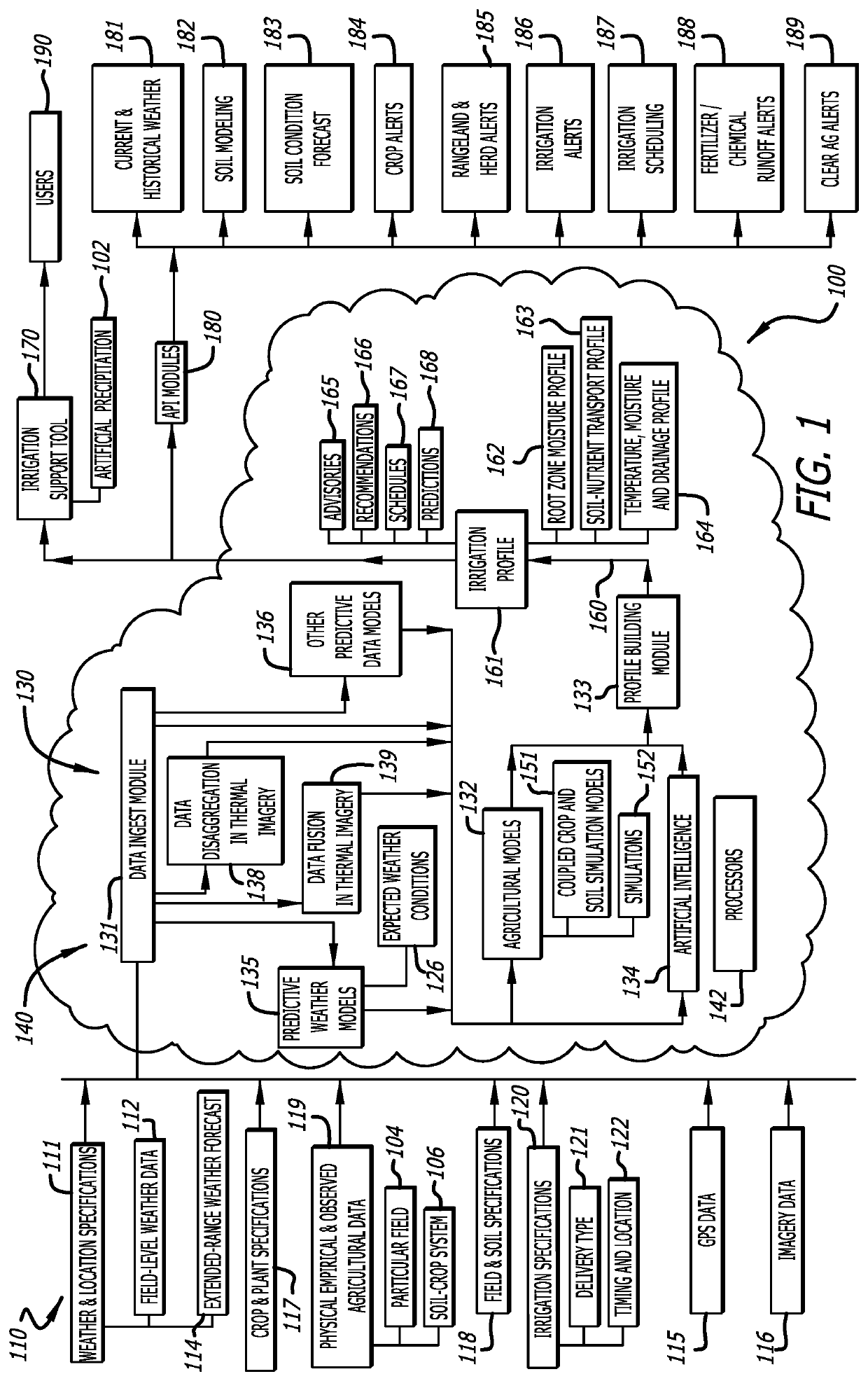
[0028]The application of a land surface model to irrigation can also lead to other improvements, such as irrigation scheduling and other irrigation-specific recommendations and advisories provided to a user. For instance, spatially-varying soil composition data within a field can be used in concert with the land surface model to create spatially-varying recommendations on the need for irrigation across a field. A land surface model with a runoff routing module can be added to further improve the simulation of the effects of terrain on the spatial variability in soil water throughout a field. The use of a land surface model with sophisticated handling of processes occurring within the crop canopy can also be used to diagnose and predict periods of leaf wetness, and to simulate the augmentation of those periods of leaf wetness by irrigation activities, as an indicator of the potential for creating unnecessary crop disease pressure through poor irrigation scheduling. This can be accomplished by organizing irrigation scheduling by management zones or other gridded breakdowns of fields, so that a variable-rate application of artificial precipitation allows for additional efficiencies in resource utilization.
[0036]It is yet another objective of the present invention to use in-situ weather and / or soil temperature or moisture observations to augment inputs to and parameters of a customized land surface model to improve the accuracy of the model at simulating conditions within the field, and thereby improving the scheduling of irrigation activities. It is a further objective of the present invention to permit the combined application of user-provided data, agronomic and land surface models and outputs, and a combination of in-situ and remotely-sensed observations of the crop in a field to diagnose the cause of areas of reduced vegetative health in a field and inform the user as to potential actions that can be taken to remedy the situation.

Problems solved by technology

In some instances, crop production is not possible without the water provided through irrigation activities, while in others irrigation may serve primarily as insurance against occasional bouts of dry weather.
Plants need to cool themselves, as when temperatures are too high, metabolic functions and growth and / or flowering may slow, stop, or the plant may even die.
The guard cells must open access to the stomata for the plant to take in carbon dioxide needed for photosynthesis, but the more they are open, the more plants transpire and lose water.
As plants transpire, water is drawn from the soil and up through the plant, causing the soil to become drier.
While widely applied, these approaches to estimating evapotranspiration have several important limitations.
Such approaches also treat the soil moisture as a simple bank, with draws and deposits, but with no understanding of the distribution or movement of water within this bank relative to the distribution and moisture uptake capacity of the plant roots.

Method used


Image

  • Customized land surface modeling in a soil-crop system using satellite data to detect irrigation and precipitation events for decision support in precision agriculture
  • Customized land surface modeling in a soil-crop system using satellite data to detect irrigation and precipitation events for decision support in precision agriculture

Examples


Embodiment Construction

[0041]In the following description of the present invention, reference is made to the exemplary embodiments illustrating the principles of the present invention and how it is practiced. Other embodiments will be utilized to practice the present invention and structural and functional changes will be made thereto without departing from the scope of the present invention.

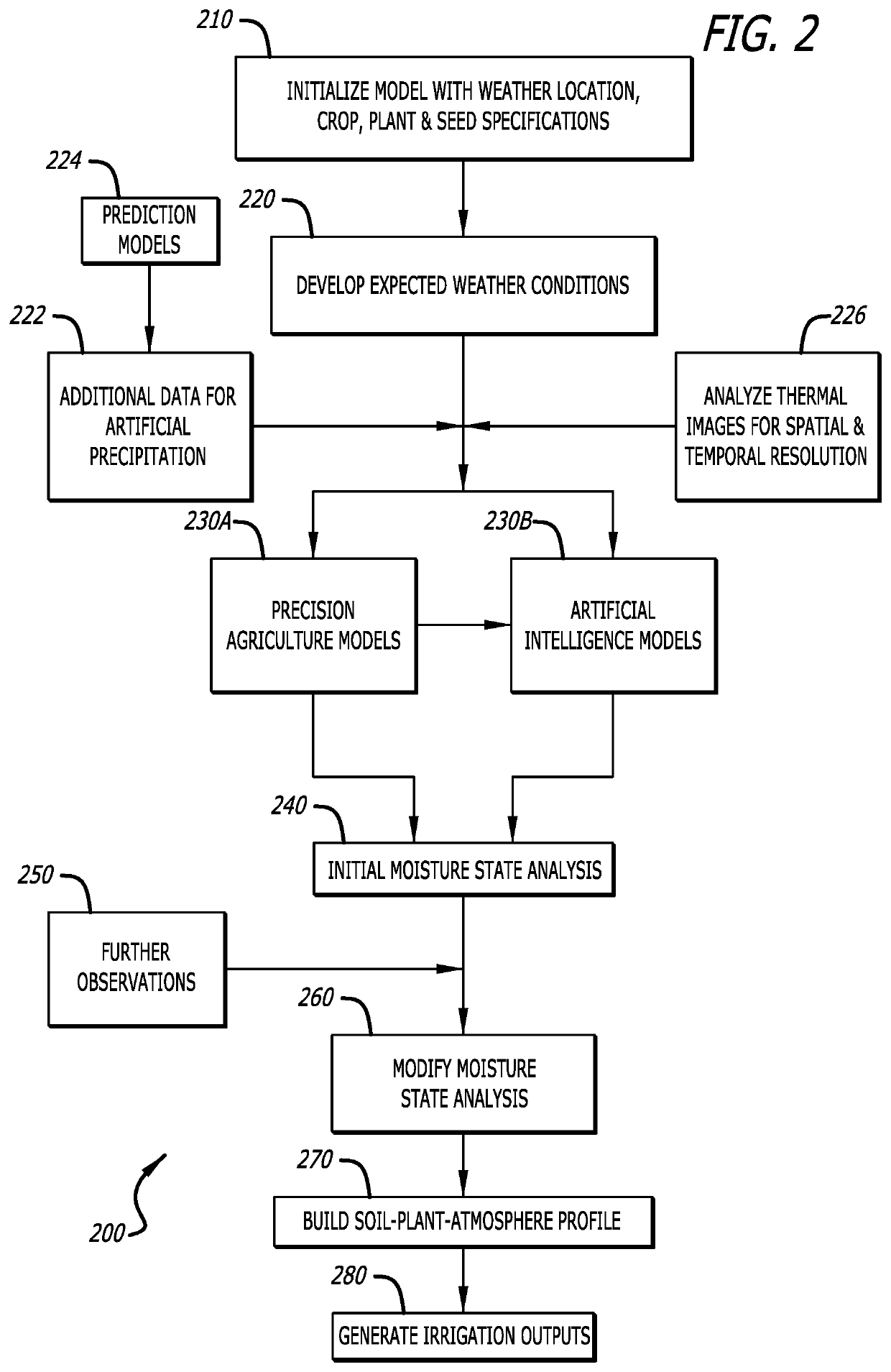
[0042]The present invention is, in one aspect thereof, an irrigation modeling framework 100 performed in one or more systems and methods that simulate, as noted above, a soil-plant-atmosphere system as it relates to moisture available to a crop and associated fields and soils, and generate one or more outputs to aid users in managing irrigation activities in precision agriculture. The soil-plant-atmosphere system is simulated in a customized land surface model, comprised of one or more coupled crop and soil simulation models of one or more physical and empirical characteristics impacting various aspects of a moisture ...


PUM


Abstract

An irrigation modeling framework in precision agriculture utilizes a combination of weather data, crop data, and other agricultural inputs to create customized agronomic models for diagnosing and predicting a moisture state in a field, and a corresponding need for, and timing of, irrigation activities. Specific combinations of various agricultural inputs can be applied, together with weather information to identify or adjust water-related characteristics of crops and soils, to model optimal irrigation activities and provide advisories, recommendations, and scheduling guidance for targeted application of artificial precipitation to address specific moisture conditions in a soil system of a field.

Description

CROSS-REFERENCE TO RELATED PATENT APPLICATION(S)[0001]This patent application claims priority to, and is a continuation-in-part of, U.S. non-provisional application Ser. No. 15 / 883,017, filed on Jan. 29, 2018, the contents of which are incorporated in their entirety herein. In accordance with 37 C.F.R. § 1.76, a claim of priority is included in an Application Data Sheet filed concurrently herewith.FIELD OF THE INVENTION[0002]The present invention relates to precision agriculture. Specifically, the present invention relates to a system and method for simulating a soil-plant-atmosphere system as it relates to moisture available to a crop and associated fields and soils for optimal management of irrigation activities, using spatially and temporally disaggregated satellite data to detect prior irrigation and precipitation events.BACKGROUND OF THE INVENTION[0003]Irrigation is a common practice in agriculture, particularly in areas that may be otherwise marginal or unsuitable for crop pro...

Claims


Application Information

Patent Timeline
Patent Type & Authority Patents(United States)
IPC IPC(8): A01G25/16G06F30/20
CPCA01G25/167G06F30/20Y02A40/10Y02A40/22A01B79/005A01G25/023G01W1/10
Inventor MEWES, JOHN J.HALE, ROBERT C.
Owner DTN LLC
Learn More