Method and software for mobile data collection having managed workflow

a mobile data and workflow technology, applied in the field of mobile data collection and maintenance of enterprise data, can solve the problems of inability to integrate data collection methods, limited flexibility of individual users, and unsuitable connected network environments for data collection, so as to speed up synchronization, reduce the quantity of data transmitted, and reduce storage space

Inactive Publication Date: 2006-12-21
AGRIGIS
View PDF18 Cites 80 Cited by
  • Summary
  • Abstract
  • Description
  • Claims
  • Application Information

AI Technical Summary

Benefits of technology

[0026] In order to reduce the quantity of data be transmitted during synchronization and to take advantage of computing power within the mobile computing device, map data is preferably rendered from a geographic database stored on the data storage device. The alternative approach is to generate map data from image files (alternatively known as shape files), which are extremely data intensive and require an inordinate amount of time to download. In contrast, a geographic database is much more efficient in terms of data storage and requires less storage space overall, speeding synchronization. A map renderer is used to generate maps from the geographic database for display on the mobile computing device. Map rendering technology is known for use, for example, in internet based mapping services, such as MapQuest™. Since map rendering requires computational power, this approach is best utilized on mobile computing devices such as laptops or tablet PC's that have sufficient CPU resources and data storage capacity to generate the images. Flexibility is also improved in this approach,

Problems solved by technology

Connected network environments are not suitable for data collection in remote areas where continuous network access is unavailable.
Disconnected environments require sufficiently small file size that they mobile users can synchronize with a network accessible master database in a reasonable amount of time, even over dial-up modem connections, and typically have suffered from a lack of comprehensive data availability that limits the flexibility of individual users.
It would be desirable to integrate work flow management with the data collection activities in order to simplify the overall process and to link these two different types of information; however, heretofore no such integrated data collection method currently exists.
Furthermore, a QA/QC mirror database is used and every change to the master database must be approved by management personnel before being posted to the master database; this is labour intensive and throughput limiting for organizations in which a large number of field workers are collecting a large quantity of data.
The rapid entry of data is often impeded in conventional systems by the need to confirm each change to the database before the change is saved, for example by clicking an “OK” button to save the change.
Heretofore, vertical databases have not been employed in GIS applications due to the difficulties in report generation with un-grouped data.
However, d

Method used


Image

  • Method and software for mobile data collection having managed workflow
  • Method and software for mobile data collection having managed workflow
  • Method and software for mobile data collection having managed workflow

Examples


Embodiment Construction

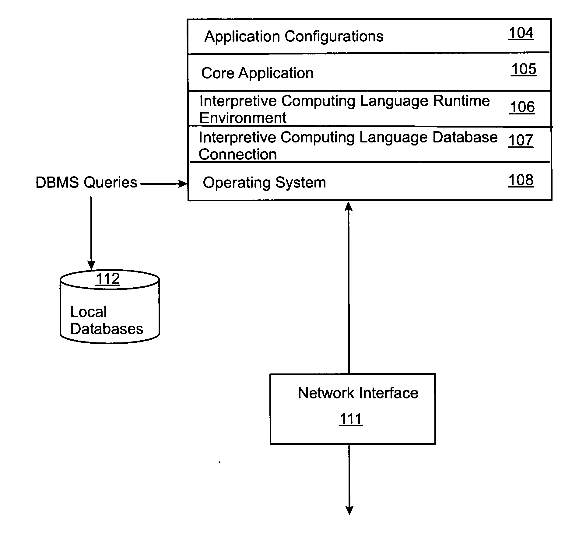
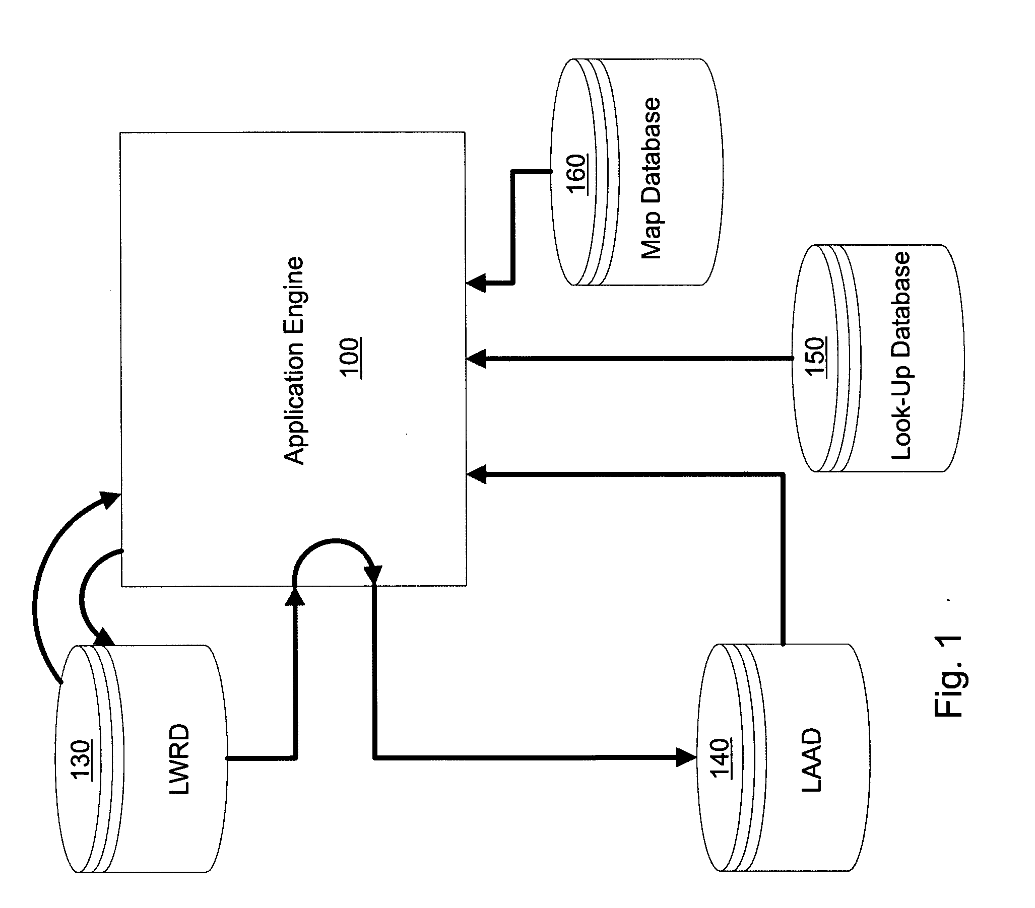
[0048] Referring to FIG. 1, the mobile computing device (preferably a tablet PC with a pen-based input device) has stored on its data storage device (preferably a hard disk drive) application software engine 100. On startup, the application engine 100 first synchronizes with the network, if available, to download work request and associated attribute information from the WRD and creates a locally-saved LWRD 130. The application engine 100 then updates or creates the LAAD 140 containing current attribute information relating to work requests stored in the LWRD 130. The application engine 100 includes code to produce a form-based graphical user interface on a visual display of the mobile computing device. The application engine 100 generates the forms by accessing a look-up database 150 that contains pre-defined categories for the user to choose from when entering data into the form (for example, pre-defined available condition states of the asset being assessed in a particular work r...


PUM


Abstract

A computerized method for collecting information on geo-spatially distributed assets. The method includes managed workflow so that work crews are automatically informed of the work that needs to be done and can report back to management when the work is completed. Mobile workers use a network-disconnected mobile computing device for data collection that includes a GPS receiver for use in generating a map showing the user's position in relation to the asset. An asset attribute database having a vertical database schema permits live-entry of the collected data without the need for confirmation, thereby speeding data entry and reducing the likelihood of data loss in the event of power failure, etc. The vertical database schema also permits data collection forms to be changed without updating the underlying database structure. The vertical database schema is converted to a relational database schema for management reporting purposes.

Description

FIELD OF THE INVENTION [0001] The invention relates to the mobile collection and maintenance of enterprise data relating to a plurality of geo-spatially distributed assets in a manner that integrates workflow management for a plurality of potential users. More particularly, the invention relates to mobile GIS data collection by a plurality of disconnected users who periodically synchronize both the collected data and workflow information with network accessible databases. BACKGROUND OF THE INVENTION [0002] In the management of geographically distributed assets it is desirable to periodically assess the condition of the assets and collect those condition assessments into a database that can then be used as a tool in planning repairs and capital expenditures. Condition assessment is normally performed by mobile workers equipped with some type of mobile computing device, such as a PDA or laptop, and a GIS database. The GIS database contains map information and asset location informatio...

Claims


Application Information

Patent Timeline
IPC IPC(8): G06F7/00
CPCG06Q10/06
Inventor EDWARDS, DAVID MICHAELSANDLER, IGOR
Owner AGRIGIS
Why Eureka
Try Eureka