Modular high-precision navigation system

a navigation system and module technology, applied in the field of navigation systems, can solve the problems of actual offset error from the intended path, tractor tilt (pitch and/or roll), and inherently limited navigation systems of current global positioning system (gps) based navigation systems, and achieve the effect of increasing the frequency of positional solutions

Inactive Publication Date: 2007-02-08
RAVEN INDUSTRIES INC
View PDF11 Cites 79 Cited by
  • Summary
  • Abstract
  • Description
  • Claims
  • Application Information

AI Technical Summary

Benefits of technology

[0016] Still another object of various embodiments of the invention is to provide a modular high-precision navigation system that uses inertial data to calculate intermediate positions between the GPS solutions resulting in an increased the frequency of positional solutions.

Problems solved by technology

Current global positioning system (GPS) based navigation systems are inherently limited in that the global position determined is actually the position of the associated antenna.
However, the tractor may, at times, encounter a side slope, causing the tractor to tilt (pitch and / or roll) wherein the antenna tilts away from the intended path and the tractor's control point.
This action corrects the apparent deviation indicated on the lightbar in this example but creates an actual offset error from the intended path.
Crop spraying aircraft, e.g., airplanes or helicopters may encounter similar problems due to tilt caused by roll, pitch and / or yaw.
In high-precision agricultural applications, as well as many other ground-based applications, such an offset results in an unacceptable expense and coverage error.
This results in coordinate location errors, and subsequent difficulties and errors in registration and incorporation in a GIS.
Similar problems may occur when boats are equipped with sonar mapping equipment.
The boat may roll, pitch and / or yaw with the waves, causing location problems and potential inaccuracies in the mapping data.
As either the degree of tilt or the antenna height increases, the associated offset error also increases.
These known INS methods do not, however, use GPS data to condition and / or calibrate the INS system.
Without the GPS data, such systems will provide poor absolute positioning over time.
Thus, for applications requiring precise positioning, including latitude, longitude and attitude, such known systems and methods are lacking and require improvement.
This integrated design creates several problems.
Such integration inhibits individualized design of the system components through element-by-element upgrades to the system.
Thus, integrated GPS / INS units are inherently limited in that they do not allow for variation of system component configuration as technology advances.
Similarly, existing systems do not allow the operator to elect to use a particular DGPS receiver in conjunction with a particular INS module to achieve optimal performance or to customize the performance to a particular need.
Moreover, these integrated unpartitioned units also fail to provide for individual system component maintenance and / or replacement if a component malfunctions or requires service.

Method used


Image

  • Modular high-precision navigation system
  • Modular high-precision navigation system
  • Modular high-precision navigation system

Examples


Embodiment Construction

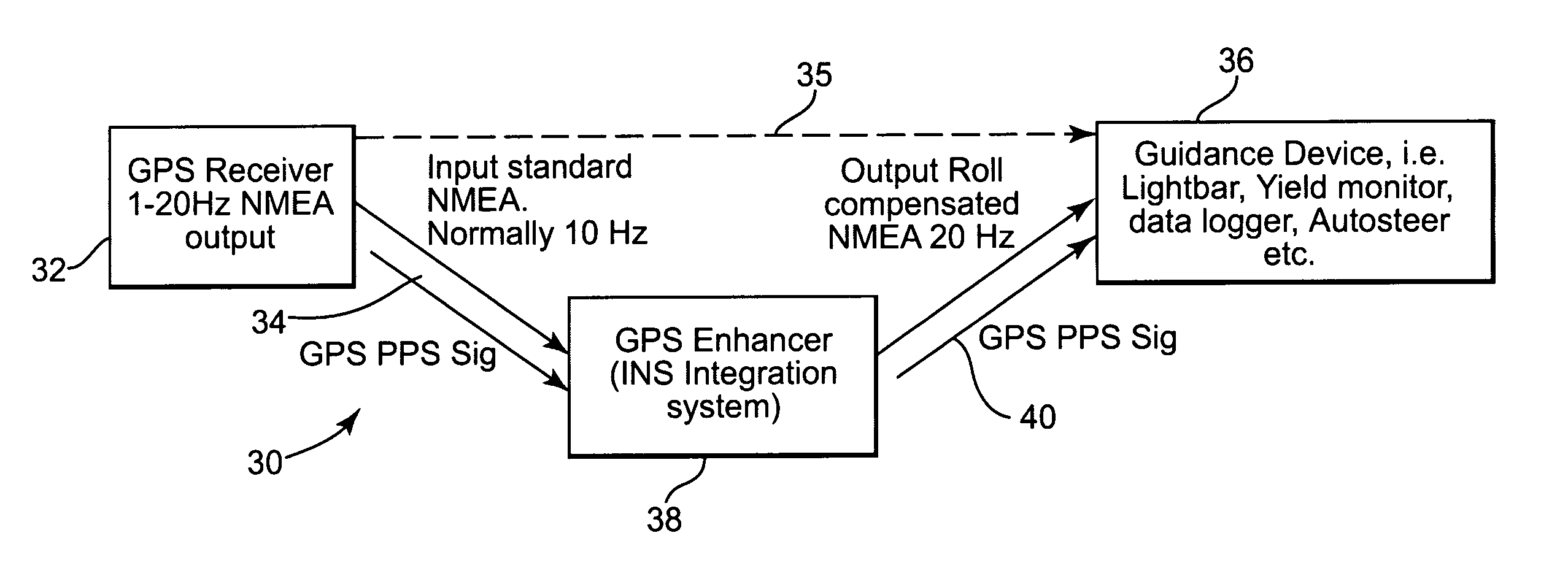
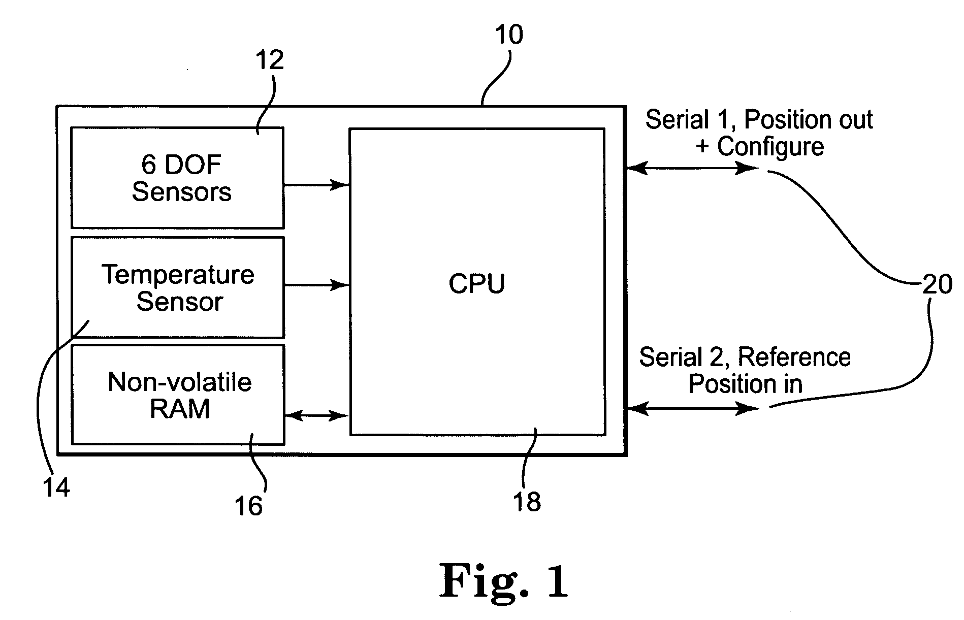
[0028] With reference to the accompanying figures, there is provided a high-precision inertial navigation module, a high-precision inertial navigation system incorporating the inertial module and associated method.

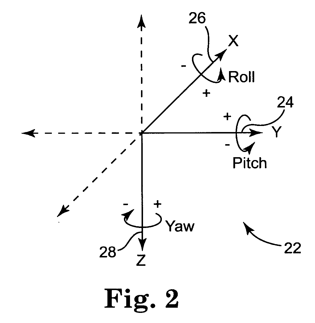
[0029] With specific reference to FIG. 1, one embodiment of a high-precision inertial navigation module 10 is provided. The module 10 comprises a gyroscope having six sensors 12, including a plurality, preferably three, accelerometers to measure acceleration along three axes (X,Y,Z) and a plurality, preferably three, angular rate sensors for measuring angular rotation around the X,Y, and Z axes. The module 10 further comprises a temperature sensor 14 to compensate and / or calibrate the sensors for performance or response variation due to variation in temperature. The module 10 also comprises non-volatile RAM 16 for storing certain calibration and discipline information for the module 10. A processor 18 is also provided, e.g., a CPU in the illustrated embodiment. The module...


PUM


Abstract

A modular device, system and associated method, used to enhance the quality and output speed of any generic GPS engine is provided. The modular device comprises an inertial subsystem based on a solid state gyroscope having a plurality of accelerometers and a plurality of angular rate sensors designed to measure linear acceleration and rotation rates around a plurality of axes. The modular inertial device may be placed in the data stream between a standard GPS receiver and a guidance device to enhance the accuracy and increase the frequency of positional solutions. Thus, the modular inertial device accepts standard GPS NMEA input messages from the source GPS receiver, corrects and enhances the GPS data using computed internal roll and pitch information, and produces an improved, more accurate, NMEA format GPS output at preferably 2 times the positional solution rate using GPS alone. The positional solution frequency using the present invention may increase to as much as 5 times that obtained using GPS alone. Moreover, the modular inertial device may assist when the GPS signal is lost for various reasons. If used without GPS, the modular inertial device may be used to define, and adjust, a vehicle's orientation on a relative basis. The modular inertial device and architecturally partitioned system incorporated into an existing GPS system may be applied to navigation generally, including high-precision land-based vehicle positioning, aerial photography, crop dusting, and sonar depth mapping to name a few applications.

Description

FIELD OF THE INVENTION [0001] This invention relates generally to a navigational system based on improving the quality and frequency of positional solutions through adjusting and / or augmenting global positioning system (GPS) data with inertial positional data. BACKGROUND OF THE PRESENT INVENTION [0002] Current global positioning system (GPS) based navigation systems are inherently limited in that the global position determined is actually the position of the associated antenna. The mounting location for this antenna must allow for a clear view of the global positioning satellites orbiting overhead. Generally, for most vehicles, planes, or vessels, the antenna location is not located generally near the desired control point, e.g., the point of highest navigational interest on the ground beneath the area of the vehicle or vessel. This control point may be, e.g., directly beneath a traveling car or truck. For a tractor or other agricultural vehicle pulling an agricultural implement suc...

Claims


Application Information

Patent Timeline
Patent Type & Authority Applications(United States)
IPC IPC(8): G01C21/00
CPCG01S19/47G01C21/165
Inventor O'FLANAGAN, JASON S.COBB, KEVIN C.FOWLER, DAVID ANTHONY
Owner RAVEN INDUSTRIES INC
Why Eureka
Try Eureka