Gradient information calculating system, vehicle running control system, navigation system, and gradient information calculating method

a technology of gradient information and calculating system, which is applied in the direction of navigation system, suspension, navigation instruments, etc., can solve the problems of insufficient gradient information for making energy consumption advance plans, unpractical plans, and expected huge costs

Active Publication Date: 2010-12-23
TOYOTA JIDOSHA KK
View PDF2 Cites 75 Cited by
  • Summary
  • Abstract
  • Description
  • Claims
  • Application Information

AI Technical Summary

Benefits of technology

[0022]According to the above-indicated aspects of the invention, the gradient information calculating system, vehicle running control system, navigation system, and the gradient information calculating method that can acquire gradient values of road at a high density, can be provided.

Problems solved by technology

However, a map DB (data base) stored in a navigation system contains gradient information for only a part of the roads, such as access roads to highways, and the thus limited gradient information is not sufficient for making of the energy consumption advance plan.
If it is planned to acquire gradient information of all of the links (roads) through measurements, or the like, and store them in the map DB, the cost is expected to be enormous, which makes the plan impractical.
However, the accuracy of commercially available GPS radio waves is intentionally reduced, and therefore, the GPS radio waves are not suitable for detecting the elevation.
Also, it is required to capture four or more GPS satellites in principle for detecting the elevation; therefore detection of the elevation is less likely to be accomplished while the vehicle is running in urban areas.
However, it is difficult to use the grid elevation data as they are for all roads, since the grid elevation data indicate an elevation of each of sections (meshes) into which a map is divided by latitudes and longitudes in a grid pattern, regardless of the presence or absence of a road in each section.
However, the navigation system of Japanese Patent No. 3985622, which uses the specific point data stored in map data and the grid elevation data, assures the accuracy of elevations only at around the specific point data, and there is a limit to the roads for which the gradients can be accurately estimated.
Namely, it is difficult to acquire accurate gradient information for roads that are spaced apart from the specific point data.

Method used


Image

  • Gradient information calculating system, vehicle running control system, navigation system, and gradient information calculating method
  • Gradient information calculating system, vehicle running control system, navigation system, and gradient information calculating method
  • Gradient information calculating system, vehicle running control system, navigation system, and gradient information calculating method

Examples


Embodiment Construction

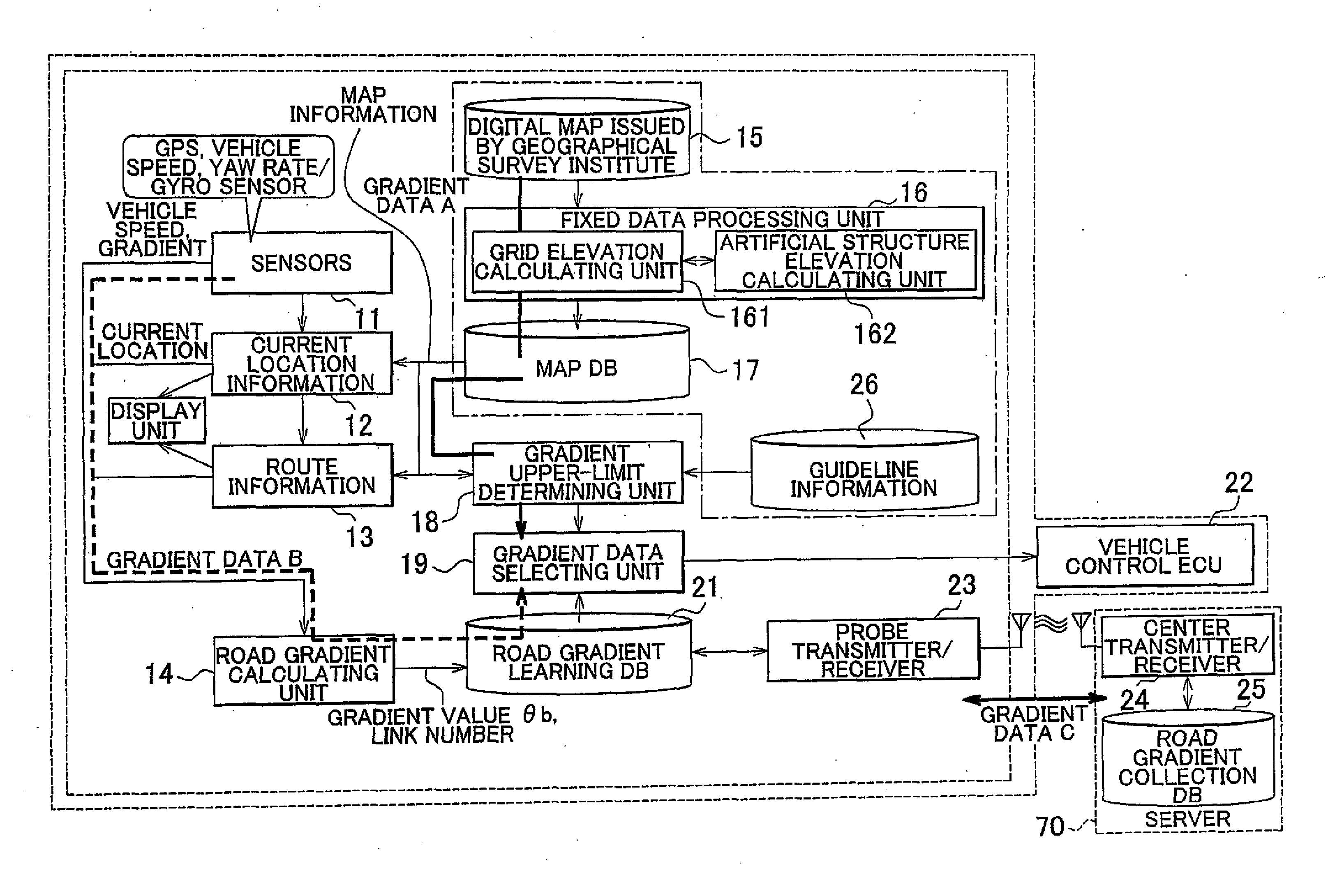
[0035]An exemplary embodiment of the invention will be described with reference to the drawings. FIG. 1 is a block diagram of a vehicle running control system 60 including a navigation system 50 according to this embodiment of the invention. The navigation system 50 acquires gradient values from three types of gradient data (gradient data A-C).

[0036]Gradient data A as second gradient values are fixed gradient values that are selected from the following three types of gradient values (A1-A3). Namely, the gradient data A consists of fixed values based on generally available values. While the values of the gradient data A may be reliable ones, the gradient data A is not necessarily available to every road.

A1) Gradient values calculated from grid elevation data released by the Geographical Survey Institute of Japan.

A2) Gradient values calculated by using artificial structures whose elevations are known.

A3) Gradient values of road gradient guidelines stipulated by statute.

[0037]On the ot...


PUM


Abstract

A gradient information calculating system includes a first calculating unit (14) that detects three-dimensional location information through autonomous navigation, and calculates a first gradient value (θb, B), based on a distance (m) traveled, and an on-plane distance (L1) obtained by projecting the distance (m) traveled on a horizontal plane, a road map information storing unit (17) that stores road map information that represents each road by nodes of which the location information is known, and a link that connects the nodes, a second calculating unit (16) that estimates elevations of the nodes from previously measured elevation data, and calculates a second gradient value (A), based on a difference in elevation between the nodes and the length of the link, and a gradient data selecting unit (19) that selects one of the first and second gradient values to be adopted as a gradient value of the link, according to a difference between the first and the second gradient values.

Description

BACKGROUND OF THE INVENTION[0001]1. Field of the Invention[0002]The invention relates to a gradient information calculating system capable of acquiring road gradient information, a vehicle running control system, a navigation system, and a gradient information calculating method.[0003]2. Description of the Related Art[0004]Vehicles, such as hybrid vehicles, which can generate electric power through regenerative braking, or the like, are able to run with high efficiency by performing driving control according to the gradients of roads. For example, the engine power is reduced and electric power is generated on downward slopes, whereas the vehicle is driven basically with the engine, with the aid of an electric motor, on upward slopes. On the basis of this concept, it is known to control the vehicle according to an energy consumption advance plan, in which the amount of energy consumed is planned in advance, based on gradient information associated with each road, so as to further imp...

Claims


Application Information

Patent Timeline
Patent Type & Authority Applications(United States)
IPC IPC(8): G01C21/26G06F7/00G01S19/42G01C21/00G08G1/0969G08G1/13G09B29/00G09B29/10
CPCB60G2400/824B60G2401/16B60G2600/0422B60G2800/019B60W2550/142B60W40/06B60W40/072B60W40/076B60W2550/141B60G2800/702B60W50/0097B60W2552/05B60W2552/15
Inventor SUGANUMA, HIDEAKIKURAISHI, MAMORU
Owner TOYOTA JIDOSHA KK
Why Eureka
Try Eureka