Systems and methods for computing vertical position

a technology of vertical position and system, applied in the field of apparatus and methods to accurately compute vertical position, can solve the problems of high cost of setting up and taking down stringlines, inconvenient operation, and numerous drawbacks of stringline systems, and achieve the effect of reducing errors

Active Publication Date: 2012-03-01
TRIMBLE NAVIGATION LTD
View PDF1 Cites 54 Cited by
  • Summary
  • Abstract
  • Description
  • Claims
  • Application Information

AI Technical Summary

Benefits of technology

[0022]An additional method for determining vertical position plus or minus 1 centimeter, 2-sigma is disclosed, comprising the steps of: determining a vertical reference position using a satellite navigation receiver; performing a first integration of the output of a navigation-grade accelerometer with respect to time; using the output of the first integration as the input to a second integration with respect to time to obtain inertial vertical position; delaying the inertial navigation position to account for the latency associated with said global navigation system receiver; subtracting the delayed inertial position from the vertical reference position; and feeding back the difference, using negative feedback, to the acceleration and velocity integrators so as to reduce the errors introduced in the acceleration and velocity integrators from the accelerometer.

Problems solved by technology

However, stringline systems have numerous drawbacks.
For example, setting up and taking down a stringline is very time consuming, usually requiring a separate crew.
Further, setting up and taking down stringlines is expensive (estimated costs for stringlines range from $10,000 to $16,000 per mile).
More importantly, stringlines, particularly those fabricated from polyethylene rope, are prone to sag.
To combat sag, aircraft cable has been employed in place of polyethylene rope, however, stretching aircraft cable to avoid sag requires a winch, which in turn consumes additional time and equipment to set up.
However, there are several drawbacks to using GNSS for this application.
For example, GNSS systems are substantially less accurate for measuring vertical position compared to horizontal position, based on (among other things) the position of the GNSS satellites in view at a given time, the unevenness of the earth's surface compared to the ellipsoid approximation of the earth's surface (employed by most GNSS receivers), along with propagation delays and multi-path errors introduced by the earth's atmosphere.
Finally, GNSS systems suffer from latency issues, for example, latency in the reference receiver data due to telemetry delay.
Hence, GNSS systems alone may not be sufficient for activities that require a great degree of vertical accuracy, in other words, applications that require vertical accuracy of one centimeter or less.
UTS systems have known drawbacks.
Even though two sets of UTSs can be leapfrogged (i.e., one system is in use while another is moved up the roadway and set up), this leapfrogging requires additional equipment and manpower.
Further, UTS systems are susceptible to environmental interference such as rain, snow, dust and wind.

Method used


Image

  • Systems and methods for computing vertical position
  • Systems and methods for computing vertical position
  • Systems and methods for computing vertical position

Examples


Embodiment Construction

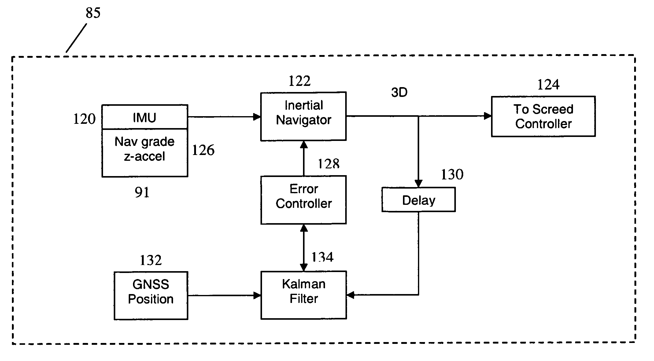
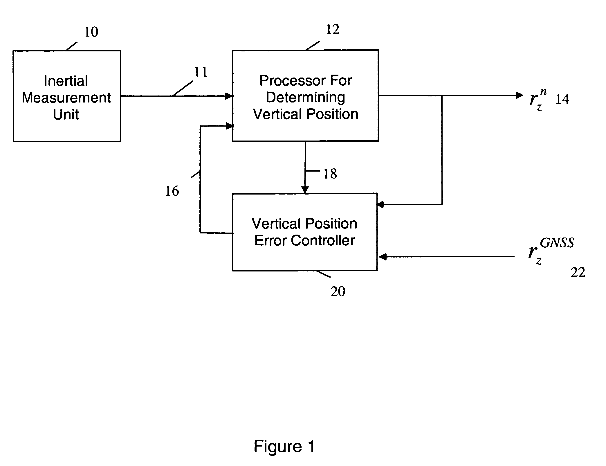
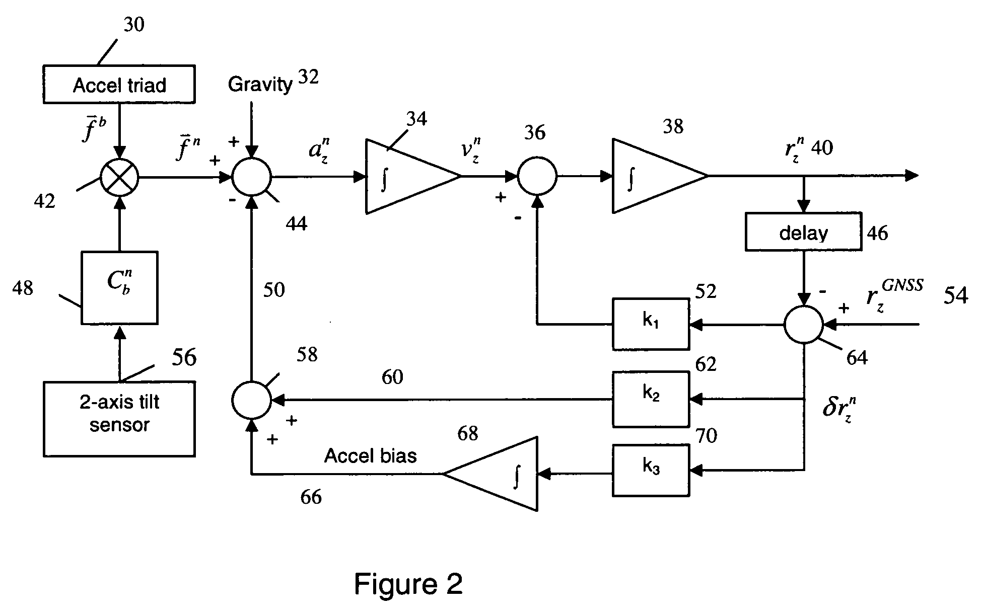
[0029]In an embodiment, an inertial navigation system is combined with a Global Navigation Satellite System (“GNSS”) to obtain a vertical position for construction equipment, such as a paver for example. This combination utilizes the attributes of GNSS and inertial navigation systems and mitigates the inherent limitations of each system when used alone. For example, an inertial navigation system may include navigation-grade accelerometers. Such a system is capable of providing near zero latency and very low short-term noise; while a GNSS offers long-term error stability. It will be understood by a person of ordinary skill in the art that a navigation-grade inertial system contains gyroscopes and accelerometers that are sufficiently accurate to provide less than 1.5 km drift per hour. However, while navigation grade inertial systems are useful, such a system is not a required element of each embodiment described in the present disclosure. Nevertheless, it has been found advantageous ...


PUM


Abstract

Control systems and methods that provide a high degree of vertical measurement accuracy for a body in motion are disclosed. The systems employ an inertial sensor system for vertical measurement and a Global Navigation Satellite System that includes multipath reduction or attenuation to provide corrected vertical information for a moving body to the inertial sensor system. The combination of these systems enables the maintenance of an accurate vertical position for said body.

Description

BACKGROUND[0001]1. Field of the Disclosure[0002]The present disclosure concerns apparatus and methods to accurately compute vertical position.[0003]2. Background of the Disclosure[0004]Modern construction and agricultural tasks often require a high degree of vertical accuracy. In fact, contracts for such projects, such as building a new highway or airport runway often have bonus fee schedules based on the extent to which the finished roadway is smooth and flat. Further, many projects include strict timetables that may also incorporate incentives for on time or early completion, and / or penalties for delays. Hence, it has become very important for contractors to complete construction projects such as roadways or runways, for example, quickly and with a high degree of vertical accuracy, often 1 centimeter, 2-sigma accuracy.[0005]Heavy equipment such as pavers have traditionally used a variety of techniques to create smooth, flat surfaces with a high degree of precision. One low tech me...

Claims


Application Information

Patent Timeline
Patent Type & Authority Applications(United States)
IPC IPC(8): G01S19/47
CPCG01S19/47G01S19/22
Inventor SCHERZINGER, BRUNOVOLLATH, ULRICH
Owner TRIMBLE NAVIGATION LTD
Why Eureka
Try Eureka