Electromagnetic surveying

a technology of electromagnetic surveying and seafloor, applied in the field of seafloor electromagnetic surveying, can solve the problems of weaker em fields seen at the detector, high cost and time consumption, and often inability to distinguish between the different possible compositions of pore fluids within, and achieve the effect of improving the signal-to-noise level

Active Publication Date: 2009-07-21
PGS GEOPHYSICAL AS
View PDF6 Cites 33 Cited by
  • Summary
  • Abstract
  • Description
  • Claims
  • Application Information

AI Technical Summary

Benefits of technology

[0023]The first technique may be a conventional magnetotelluric (MT) processing technique. This is a known way of analysing TE dominated data to obtain information on large-scale subterranean strata. Furthermore, processing the subset of the electromagnetic field data in accordance with the first technique may include combining data from different source-receiver separations into a single datum. This allows for an improved signal-to-noise level without necessarily adversely impacting spatial resolution.

Problems solved by technology

However, whilst seismic surveying is able to identify such structures, the technique is often unable to distinguish between the different possible compositions of pore fluids within them.
However, this is expensive and time consuming.
Conversely, the presence of relatively more conductive structures in the subterranean strata will, in general, lead to weaker EM fields seen at the detector.
Thus for the TM mode even a thin resistive layer strongly affects the EM fields detected at the receiver since the large scale current flow pattern is disrupted by the resistive layer.
However, a drawback of this geometric-splitting based approach is the need to obtain data for multiple specific source-receiver alignments results in complex tow paths.
These are costly and time consuming to perform and provide relatively little data of the highest possible quality (since much of the data is neither inline nor broadside but is intermediate between the two).
However, these mathematical decomposition schemes are relatively sensitive to noise in the CSEM data sets, and also require specialised receiver designs which capable of measuring spatial gradients in electromagnetic field components.
The long wavelength signals which do penetrate to the seafloor do not provide sufficient spatial resolution to examine the electrical properties of small scale subterranean reservoirs, but can be used for larger-scale undersea probing.
Furthermore the MT signals at the seafloor comprise primarily horizontally polarised EM fields and so are intrinsically insensitive to thin resistive layers.
However, a drawback of the CSEM plus MT technique is the need to separately acquire two independent data sets.
Furthermore, MT signals are uncontrolled and often weak.
This means a significant amount of data stacking can be required to reach an appropriate signal to noise ratio.
In some cases several days of MT data must be recorded to ensure signal quality, increasing the time for which receivers must be deployed compared to a standard CSEM survey and therefore the overall commercial cost.
Furthermore still, only low frequency data can generally be used as higher frequency signals undergo too much attenuation in seawater overlaying the area being surveyed.
This makes each data set differently sensitive to different regions in the subterranean strata and this increases the complexity of data interpretation.

Method used


Image

  • Electromagnetic surveying
  • Electromagnetic surveying
  • Electromagnetic surveying

Examples


Embodiment Construction

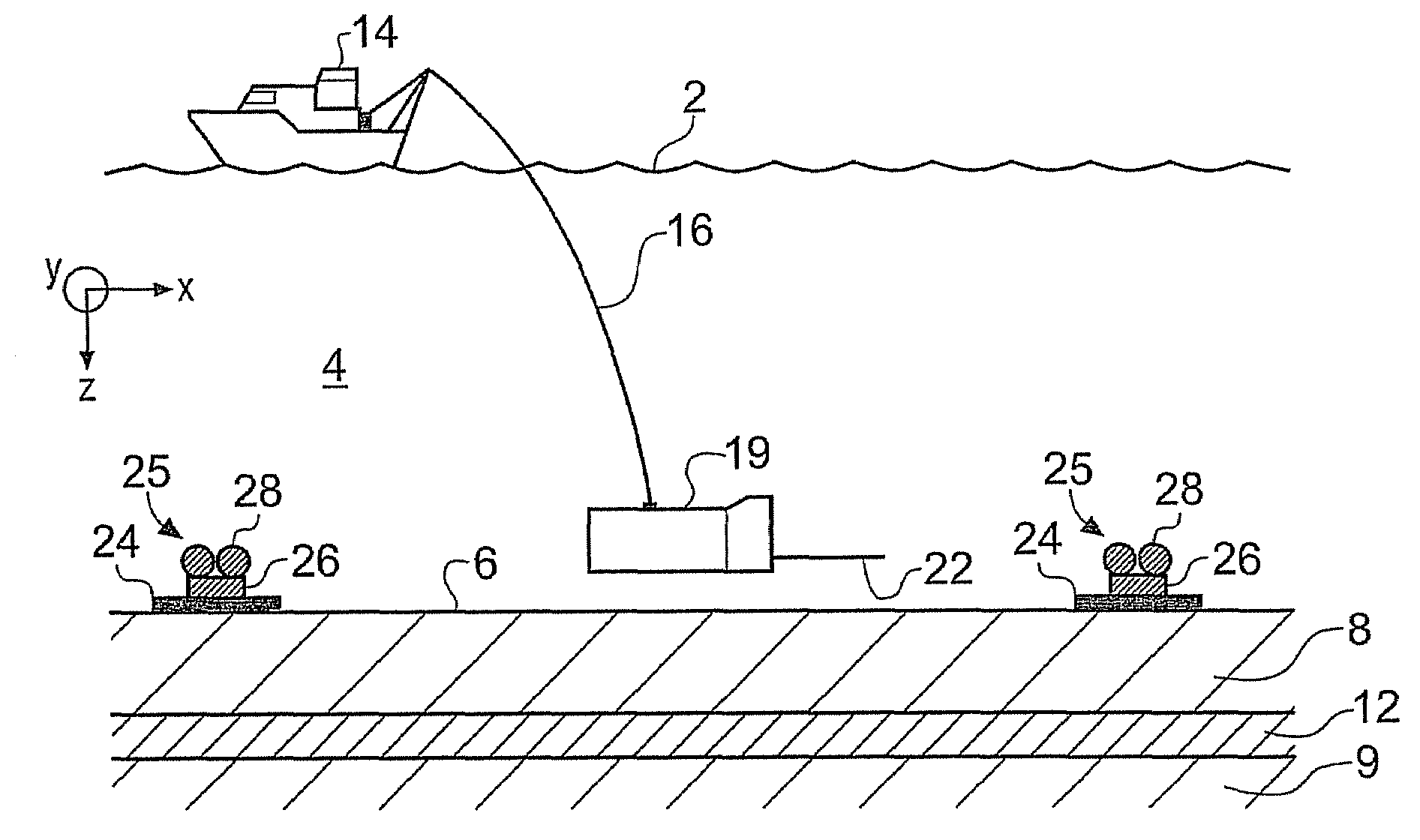
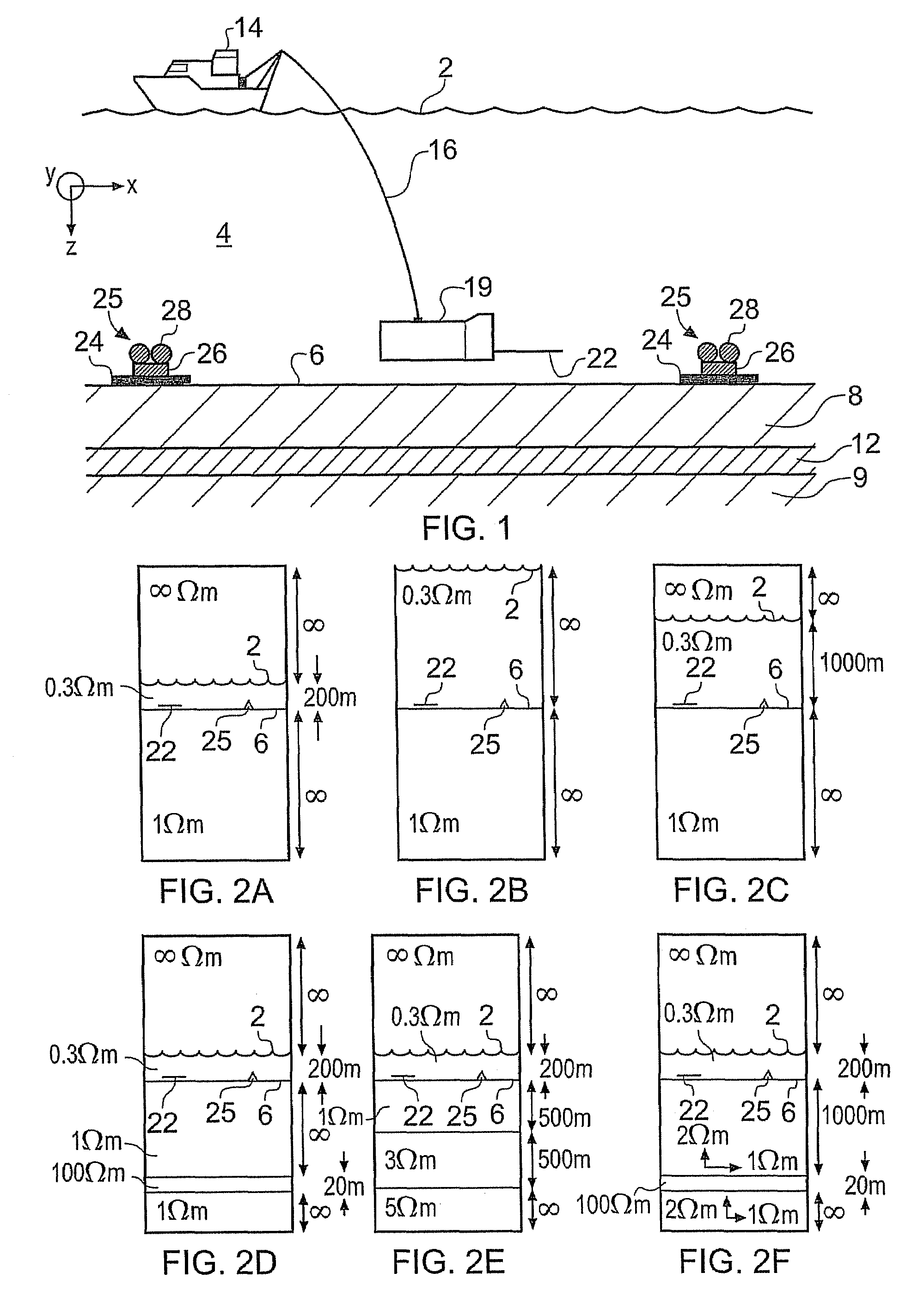
[0075]FIG. 1 schematically shows a surface vessel 14 undertaking controlled source electromagnetic (CSEM) surveying of a subterranean strata configuration using standard apparatus [1] to obtain data suitable for analysis according to an embodiment of the invention. The subterranean strata in this example includes an overburden layer 8, an underburden layer 9 and a hydrocarbon reservoir 12. The surface vessel 14 floats on the surface 2 of a body of water, in this case seawater 4. A submersible vehicle 19 carrying a source (transmitter) 22 in the form of a horizontal electric dipole (HED) is attached to the surface vessel 14 by an umbilical cable 16. The umbilical cable provides an electrical, mechanical and optical connection between the submersible vehicle 19 and the surface vessel 14. The HED source 22 is supplied with a drive current such that it broadcasts an HED electromagnetic (EM) signal into the seawater.

[0076]One or more remote receivers (detectors) 25 are located on the sea...


PUM


Abstract

A method of analysing results from an electromagnetic survey of an area that is thought or known to contain a subterranean resistive or conductive body within a background strata configuration is described. The method comprises providing a set of electromagnetic field data obtained using at least one electromagnetic receiver and at least one electromagnetic source for a range of source-receiver separations, e.g. providing conventional controlled-source electromagnetic survey data. A subset of the electromagnetic field data is identified that comprises data obtained for source-receiver separations greater than a selected threshold offset. The threshold offset is chosen so that data beyond this offset are characteristic of magnetotelluric data. Thus the subset of data is then processed in accordance with a first technique to obtain information on the background strata configuration. Other electromagnetic field data obtained for source-receiver separations less than the threshold offset may then be processed in accordance with a second technique to obtain information on any subterranean resistive or conductive body within the background strata configuration.

Description

BACKGROUND ART[0001]The invention relates to seafloor electromagnetic surveying for resistive and / or conductive bodies, for example for oil, gas, methane hydrates etc. and other hydrocarbon reserves or subterranean salt bodies.[0002]Seismic techniques are frequently used during hydrocarbon-exploration expeditions, to identify the existence, location and extent of reservoirs in subterranean rock strata. However, whilst seismic surveying is able to identify such structures, the technique is often unable to distinguish between the different possible compositions of pore fluids within them. This is especially so for pore fluids which have similar mechanical properties, such as oil and seawater. It is therefore generally necessary to employ other survey techniques to determine whether a previously identified reservoir contains oil, for example, or just aqueous pore fluids. One technique is exploratory well drilling in the region of potential interest. However, this is expensive and time ...

Claims


Application Information

Patent Timeline
Patent Type & Authority Patents(United States)
IPC IPC(8): G06F19/00
CPCG01V3/12G01V3/083E21B2043/0115E21B41/0099G01V3/38
Inventor ANDREIS, DAVIDMACGREGOR, LUCYGOLUBEV, NIKOLAY
Owner PGS GEOPHYSICAL AS
Why Eureka
Try Eureka