Real-time presentation of geolocated entities for emergency response

Active Publication Date: 2017-06-13
AZTEK SECURITIES LLC
View PDF14 Cites 3 Cited by
  • Summary
  • Abstract
  • Description
  • Claims
  • Application Information

AI Technical Summary

Benefits of technology

The invention provides a system that allows quick access to real-time data through internet and cell phones. It has separate layers for different agencies to access relevant data while keeping track of the overall situation. GPS tracking helps with accurate location information. It also has extended data on entities for better response and training purposes. The system allows for easy access to training scenarios, creates a repository for quick data access, and provides drawing tools for extracting data from different locations.

Problems solved by technology

This resulted in several problems, including confusion about the latest data versus stale data, delays in incident response due to printing and notating, tediousness of distributing paper copies to all involved agencies, delays in incident response due to different agencies tracking activities in a manner that first responders do not readily have the latest information, maintenance of several maps to deliver data pertinent to an agency, uncertainty over data accuracy due to extended data having to be pulled from several different sources and datasets and dependence on the dataset provider, and difficulties in training due to maintenance of paper copies being cumbersome and time-consuming.
From a technical standpoint, conventional computer-based technologies are incapable of formulating data-based mitigation plans in response to the occurrence of a particular incident or hazard as the appropriate server-client communication channels did not exist, along with a lack of an ability to display the assimilated data in overlaying fashion on a map or other diagram on which the incident is indicated.
This is inefficient, and an unconventional solution to this technical problem is sought herein.

Method used


Image

  • Real-time presentation of geolocated entities for emergency response
  • Real-time presentation of geolocated entities for emergency response
  • Real-time presentation of geolocated entities for emergency response

Examples


example 1

Response

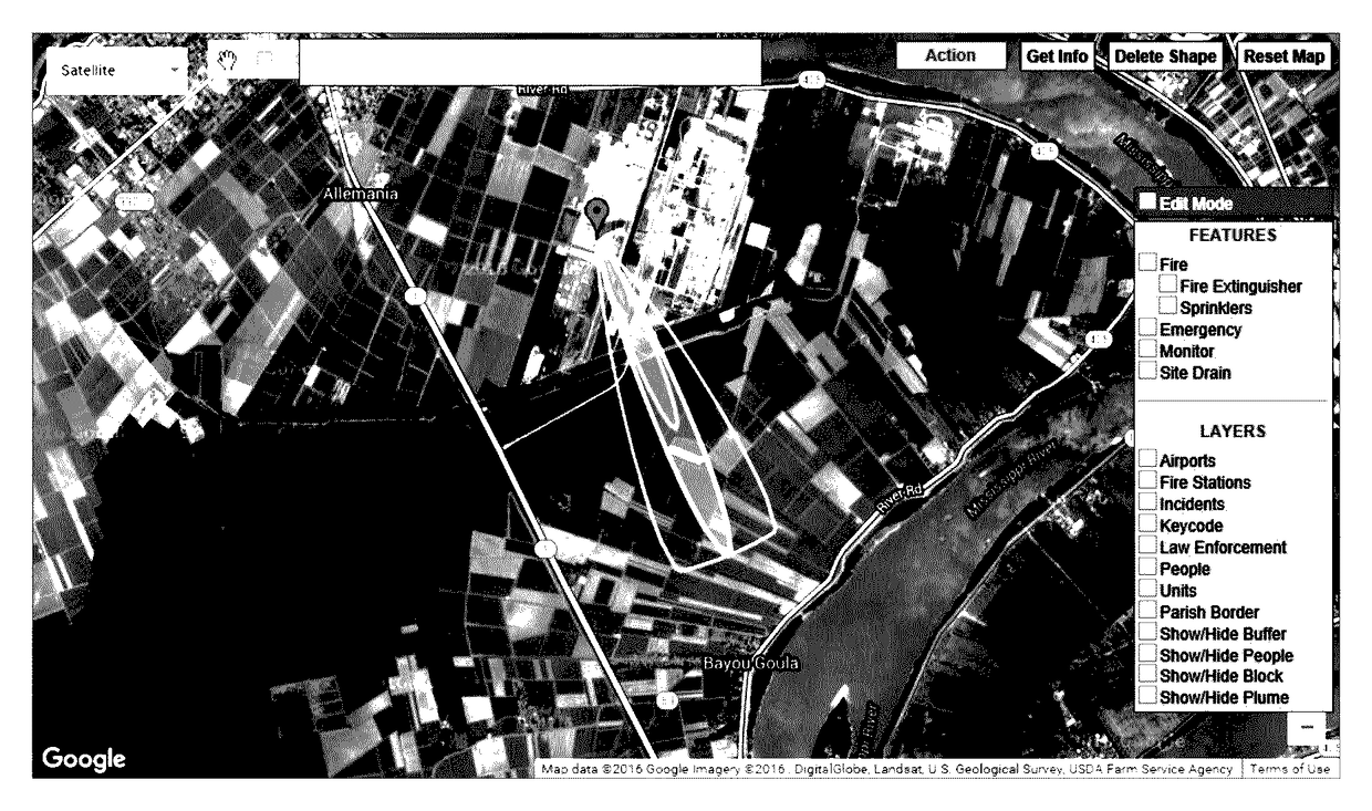
[0043]In certain embodiments, the current invention is a system and methodology for extracting and displaying real-time geographical and situational details on-site, as used / operated by first responders and emergency personnel in incidence responses. The system relies on a wireless network (e.g., cellular network), Internet connection, or other network connection to provide instant access to information pertaining to the underlying incident and the response thereto. The system enhances the user / operator's capability to quickly detect, record, and share response activities and tasks in real-time.

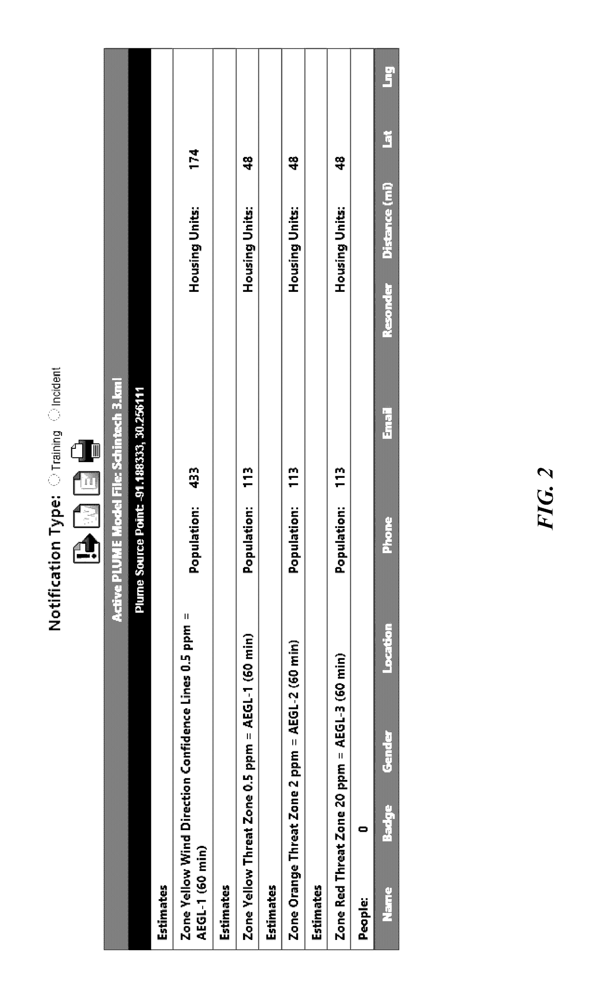
[0044]The system and methodology displays an aerial dispersal model (e.g., ALOHA plume) containing a plurality of informational layers underlying the plume, where the system overlays the plume on a web mapping service for user visualization. The information includes, but is not limited to, population, housing, public facilities, demographics, transportation systems and roadways, and i...

example 2

intenance

[0052]The system can also provide data in real-time for a safety audit. Generally, rather than presenting data and entities under a plume as in Example 1, the current system can present the same information under a preselected area on a map for audit / maintenance purposes. It has entity maintenance features that aid in providing up-to-date, accurate information for the underlying entities / features. A user can input a particular area on the map (e.g., drawing an enclosed region on GOOGLE MAPS), and the underlying entities / features can be seen, maintained, and updated. Data for emergency features, for example including, but not limited to, the locations of fire hydrants, fire extinguishers, hoses, valves, pipelines, etc., can be managed and maintained within the system. As an example, a building's floorplan or other infrastructure, as inputted or imported by the user, can be visualized, such that particular incidences (e.g., slip and fall accidents in a hospital setting) and o...

example 3

sed Response

[0056]FIGS. 7, 8, and 9A-9B depict the system components used to accomplish the functionality described previously, specifically displaying in real-time geographical and situational details on-site underneath a conveyed or preselected region displayed on a web mapping service. System server 10 is a computer device that provides functionality for other client devices. In certain embodiments, the web-based architecture of the current system adheres to a client-server model, and a single overall computation is distributed across multiple devices. System server 10 provides various functionalities and services, including, but not limited to, sharing data and resources among multiple client devices and performing computations for a client device. System server 10 can serve multiple clients simultaneously, thus sharing data in real-time. Other than this computational functionality, system server 10 also hosts the database that stores all data required for the current operation....


PUM


Abstract

A system and corresponding methodology for displaying in real-time geographical and situational details on-site underneath a conveyed or preselected region displayed on a web mapping service, wherein these geographical and situational details include information that is overlaid over top the conveyed or preselected region on the web map. The system can be used to formulate and implement incident / emergency response by providing knowledge under a plume, and / or can also be used to display entity information under a selected region for audit / maintenance purposes.

Description

CROSS-REFERENCE TO RELATED APPLICATIONS[0001]This nonprovisional application claims priority to U.S. Provisional Patent Application No. 62 / 408,277, entitled “Geolocation presentation of entities on map while safety incident or training.”, filed Oct. 14, 2016 by the same inventors, the entirety of which is incorporated herein by reference.BACKGROUND OF THE INVENTION[0002]1. Field of the Invention[0003]This invention relates, generally, to incident responses. More specifically, it relates to providing vital information to first responders in helping formulate and implement a mitigation response plan.[0004]2. Brief Description of the Prior Art[0005]Incident management describes actions taken to identify, analyze, and correct hazards that have occurred and to prevent re-occurrences of such hazards. These actions are taken by an incident response team, who prepare for and respond to an emergency incident. The goal is to handle the situation in a way that limits damage and reduces recover...

Claims


Application Information

Patent Timeline
IPC IPC(8): G06T11/00G09G5/377G06T11/20G06F17/30G09B29/10G06F17/27
CPCG09G5/377G06T11/206G06F17/30241G09B29/102G06T2210/21G06T2207/20112G06F17/2725G06Q10/06G06T11/60G06F16/29
Inventor KAMATH, NITINKAMATH, SACHINKAMATH, APARNA
Owner AZTEK SECURITIES LLC
Why Eureka
Try Eureka