
Three-dimensional polarization imaging lidar remote sensor

A laser radar, polarization imaging technology, applied in the direction of instruments, re-radiation of electromagnetic waves, utilization of re-radiation, etc., can solve the problems of difficult to manufacture, heavy weight, large volume, etc.

Inactive Publication Date: 2008-06-18
BEIHANG UNIV
View PDF0 Cites 38 Cited by
  • Summary
  • Abstract
  • Description
  • Claims
  • Application Information

AI Technical Summary

Problems solved by technology

[0002] At present, there are a variety of lidar remote sensing technologies, such as time-of-flight coding based on laser pulses, laser echo intensity coding, and laser echo waveform coding, which are applied to atmospheric remote sensing, hydrological remote sensing, surface feature research, and trace gas detection. Single-wavelength laser radar remote sensing technology. In recent years, research on polarization imaging laser radar remote sensing technology has been carried out internationally to expand traditional laser radar remote sensing technology in some applications of vegetation classification remote sensing, crop yield evaluation remote sensing, and military remote sensing. In particular, in recent years, the newly developed polarization imaging laser radar remote sensor in the world has received much attention. The most advanced technology is the dual-wavelength polarization imaging remote sensor in the United States, but the remote sensor system is designed with refraction and transmission optical systems. method, not only has the disadvantages of complex system, large volume, heavy weight, complicated process and difficult to manufacture, but also requires two lasers, large loss of light energy in the refraction and projection optical system, and is difficult for aerospace long-distance remote sensing

Method used


Image

  • Three-dimensional polarization imaging lidar remote sensor
  • Three-dimensional polarization imaging lidar remote sensor
  • Three-dimensional polarization imaging lidar remote sensor

Examples


Embodiment Construction

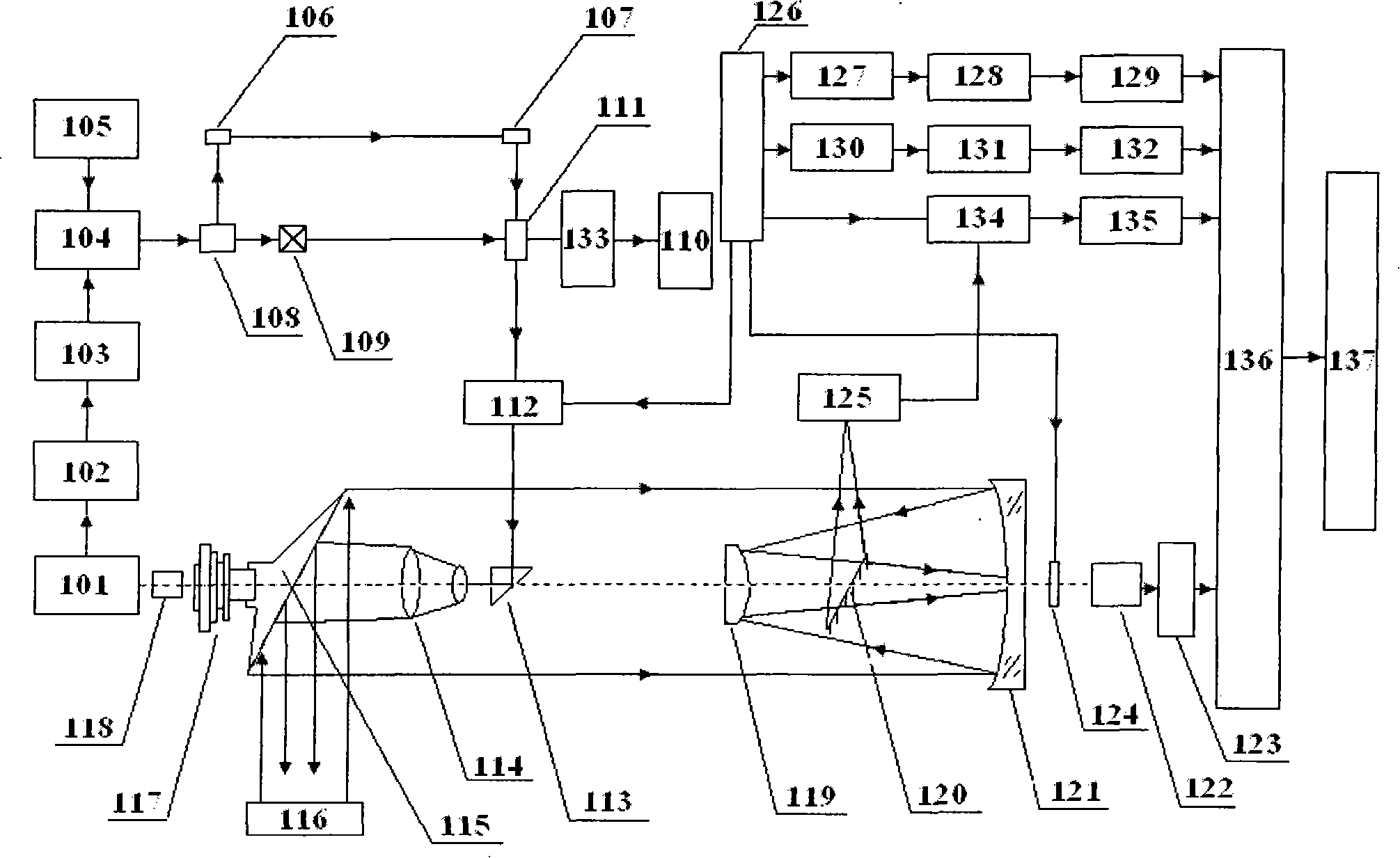
[0016] The synchronous signal generator 101 sends a synchronous timing signal, through the laser emission pulse distributor 102 and the synchronous controller 103, controls the laser 104 with the cooling system 105 to emit a laser pulse with a wavelength of λ according to the synchronous timing signal. The laser pulse is divided into two polarized beams of equal energy propagating along the original beam direction and the direction perpendicular to the original beam direction respectively after passing through the cube polarized beam splitter 108, wherein the polarized beam along the original beam direction is converted into a wavelength by a frequency multiplier 109 It is a laser pulse of λ / 2, and the laser pulse is passed through a laser with a transmittance of 2% to λ / 2, a reflectivity of 98%, a light completely transparent to λ, and placed at an angle of 45° to the λ / 2 optical path. Partial transmission reflector 111, the laser pulse with energy of 2% is received by unit ph...


PUM


Abstract

The invention discloses a three dimensional polarization image laser radar remote sensor. The invention comprises a light path system, a device for the generation of polarization light and the reception of dispersion light, the generation of three dimensional data and a processing method for three dimensional data. The invention is characterized in that the light path system is the same optical system which is composed by a range finder and a device for the generation, emission and detection of the polarization light. The device for the generation, emission and detection of the polarization light comprises a laser instrument, a beam splitter, a double frequency crystal, a plurality of lenses, a code disc, a scan motor, a scanning mirror, a telescope, a polarizer, a wave plate, an echo ranging reception device, a color separation filter, a CCD and a computer. The generation device and the method for target three dimensional surface data comprises a distance measurement device and the method for distance measurement data generation, location data generation and remote sensor attitude data generation. The processing method for polarization image data and three dimensional surface data comprises the processing method for laser distance measurement data, location data and attitude data. The invention can obtain the three dimensional image of the detected target with polarization information.

Description

【Technical field】 [0001] The present invention is a three-dimensional polarization imaging lidar remote sensor, which mainly uses laser polarization imaging measurement technology, laser ranging technology, GPS positioning measurement technology, attitude measurement technology and data integration and processing technology to combine into an organic whole to realize three-dimensional polarization Imaging lidar remote sensor. 【Background technique】 [0002] At present, there are a variety of lidar remote sensing technologies, such as time-of-flight coding based on laser pulses, laser echo intensity coding, and laser echo waveform coding, which are applied to atmospheric remote sensing, hydrological remote sensing, surface feature research, and trace gas detection. Single-wavelength laser radar remote sensing technology. In recent years, research on polarization imaging laser radar remote sensing technology has been carried out internationally to expand traditional laser rada...

Claims


Application Information

Patent Timeline
IPC IPC(8): G01S17/89
Inventor 江月松李小路何云涛
Owner BEIHANG UNIV
Learn More