Fast forest fire detecting system by laser ranging positioning

A technology of laser distance measurement and forest fire, which is applied in radio wave measurement system, positioning, fire alarm, etc., to achieve the effect of high installation cost, simple use, and prevention of information transmission failure

Inactive Publication Date: 2009-10-07
SHANGHAI INST OF TECHNICAL PHYSICS - CHINESE ACAD OF SCI
View PDF0 Cites 17 Cited by
  • Summary
  • Abstract
  • Description
  • Claims
  • Application Information

AI Technical Summary

Problems solved by technology

[0004] With the development of laser and electronic technology, laser range finders have been widely used, but tradi

Method used


Image

  • Fast forest fire detecting system by laser ranging positioning
  • Fast forest fire detecting system by laser ranging positioning

Examples


Embodiment Construction

[0039] Provide an embodiment of the present invention below in conjunction with accompanying drawing.

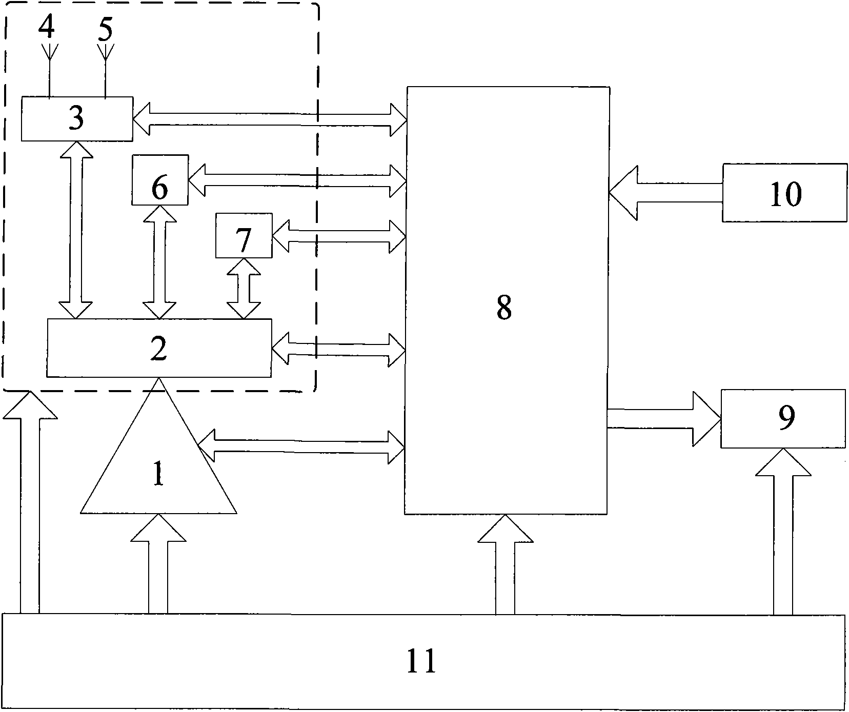
[0040] refer to figure 1 , In the implementation example, the LRB20000B laser rangefinder of NEWCON Company is used, which integrates a digital compass and a magnetic inclinometer, RS232 output, a range of 100-20000m, a distance measurement accuracy of + / -3.5m, and an azimuth measurement accuracy of + / -1 degrees, tilt angle measurement accuracy + / -0.4 degrees, weight 2.5kg. The GPS / Beidou dual-mode positioning communication module selects the Beidou / GPS dual-mode all-in-one machine of Nanjing Compass Company, which can simultaneously receive the signals of Beidou first-generation satellites and GPS satellites for positioning, and integrates the short message communication function of Beidou first-generation, RS232 communication interface . The processor adopts LPC2300 series 32-bit ARM7 chip, the processor clock is up to 72MHz, and the chip integrates up to 512KB of Flash...


PUM


Abstract

The invention discloses a fast forest fire detecting system by laser ranging positioning, composed of a laser ranging positioning unit and a command information platform. The invention mainly discloses a laser ranging positioning unit integrating a laser ranging module, a digital compass, a dip circle and a GPS/Beidou double-module positioning communication module, and adopts short message communicating function of a Beidou first-generation satellite to send fire condition information. Advantages are as follows: compared with the traditional mapping tools, the laser ranging positioning unit more quickly measure three-dimensional coordinate of an ignition point distantly and saves precious time at the beginning of finding forest fire; the method of positioning by Beidou double-module positioning has higher positioning precision; Beidou first-generation communication link is safer, more reliable and stable, compared with wired communication network or other wireless communication ways; the command information platform monitoring system base on 3D-GIS database can accurately and directly display specific position of the fire and provide effective instruction for organizing to extinguish fire.

Description

Technical field: [0001] The invention belongs to the technical field of geographic location measurement, and specifically refers to a system and method for quickly detecting forest fires by laser ranging and positioning. It is used to measure the three-dimensional coordinates of forest fire locations, and transmit the fire location information in real time through Beidou first-generation satellites to the command information platform, so as to realize rapid positioning and alarm when a fire is found. Background technique: [0002] Forest is one of the important resources for human beings to survive. However, due to man-made or natural factors, forest fires occur every year, severely damaging the ecological environment and national economy. Since 1950, an average of 13,067 forest fires have occurred in my country every year, and the affected forest area is 653,019 hectares. According to the size of forest fires, forest fires can be divided into forest fires (the affected for...

Claims


Application Information

Patent Timeline
IPC IPC(8): G01S17/08G01S7/48G01C1/00G01S5/02G08B17/00G08B25/00
Inventor 刘济帆张雷王建宇
Owner SHANGHAI INST OF TECHNICAL PHYSICS - CHINESE ACAD OF SCI
Why Eureka
Try Eureka