A Method for Realizing Remote Sensing Scene Simulation of Undulating Terrain

A scene simulation and terrain technology, applied in the field of remote sensing imaging simulation, can solve the problems of low simulation results, complex and changeable surface conditions, and simulation results errors, and achieve the effects of improving simulation accuracy, overcoming simulation errors, and high-precision simulation.

Inactive Publication Date: 2011-12-14
BEIHANG UNIV
View PDF0 Cites 0 Cited by
  • Summary
  • Abstract
  • Description
  • Claims
  • Application Information

AI Technical Summary

Problems solved by technology

[0004] There are many factors involved in converting the irradiance received on the horizontal ground to the undulating terrain, and the existing technologies adopt a simplified method: one is to consider only the influence of low-order items and linearize the complex nonlinear calculation process; the other is to ignore some factors , simplify terrain information extraction
The irradiance received by the undulating ground is a complex nonlinear calculation process, and linearization will bring errors to the simulation results
Ignoring some influencing factors and simplifying the extraction of topographical information leads to low accuracy of simulation results. At the same time, the surface conditions are complex and changeable. Usually, factors that have a small impact and can be ignored, in some cases, become irrelevant, resulting in simulation results that are different from those of The radiance actually received by the entrance pupil of the sensor has a large discrepancy

Method used


Image

  • A Method for Realizing Remote Sensing Scene Simulation of Undulating Terrain
  • A Method for Realizing Remote Sensing Scene Simulation of Undulating Terrain
  • A Method for Realizing Remote Sensing Scene Simulation of Undulating Terrain

Examples


Embodiment Construction

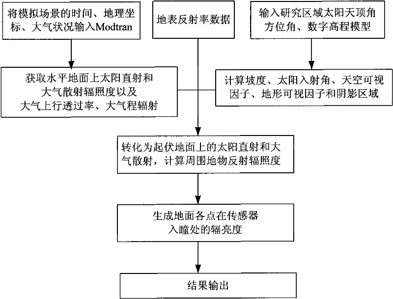
[0037] Taking the remote sensing scene simulation process in the Qulong area of ​​Tibet as an example, as follows: figure 1 Shown, the concrete implementation method of the present invention is as follows:

[0038] (1) Input the simulated scene time, geographic coordinates, and atmospheric conditions into Modtran to obtain direct solar and atmospheric diffuse irradiance on the horizontal ground, atmospheric uplink transmittance, and atmospheric pass radiation.

[0039] A digital elevation model with a ground resolution of 30m and surface albedo data in the Qulong area of ​​Tibet is used. The simulation scene time is set at 10:6:56 am on April 3, 2002, the atmospheric condition is mid-latitude summer in the US standard atmosphere, and the geographical coordinates of the regional center are 29.98°N, 36.37°E. Run Modtran multiple times to obtain the direct solar irradiance received by the horizontal ground, atmospheric diffuse irradiance, atmospheric uplink transmittance, and at...


PUM


Abstract

A method for realizing remote sensing scene simulation of undulating terrain, (1) Input the time, geographic coordinates, and atmospheric conditions of the simulated scene into the medium spectral resolution atmospheric transmittance model Modtran, and obtain direct solar and atmospheric irradiance and atmospheric irradiance on the horizontal ground Uplink transmittance, atmospheric radiation; (2) input solar zenith angle, azimuth angle and digital elevation model, and calculate slope, aspect, solar incidence angle, sky visibility factor, terrain visibility factor and shadow area; (3 ) Calculate the direct solar irradiance and Atmospheric scattering irradiance, calculate the reflection irradiance of surrounding objects, these three parts constitute the total irradiance received by the surface; (4) use the surface albedo data, atmospheric uplink transmittance and atmospheric radiation to generate the ground each The radiance data of a point at the entrance pupil of the sensor.

Description

Technical field [0001] The invention relates to a method for realizing remote sensing scene simulation of undulating terrain, especially a method for generating sensor pupil radiance data under undulating terrain, which has important value in surface irradiance calculation and remote sensing imaging simulation, and belongs to remote sensing imaging simulation technology field. Background technique [0002] The generation of sensor entrance pupil radiance data is the key technology of remote sensing scene simulation. In the case of a flat and uniform surface, the illumination received by the ground includes two parts: direct sunlight and atmospheric scattered light. These two parts enter the sensor after being reflected by the ground and transmitted by the atmosphere. At the same time, the atmospheric path radiation also enters the sensor. In practice, the terrain fluctuates, and the atmospheric radiation is not affected by the terrain fluctuations; however, the direct sunl...

Claims


Application Information

Patent Timeline
Patent Type & Authority Patents(China)
IPC IPC(8): G06T17/00G06T17/05G01S17/88
Inventor 赵慧洁王亚超贾国瑞江澄李娜
Owner BEIHANG UNIV
Why Eureka
Try Eureka