Safe pointing and safe distance real-time monitoring system

A technology of safe distance and real-time monitoring, applied in radio wave measurement system, surveying and navigation, utilization of re-radiation, etc., can solve the problem of inability to ensure effective measurement of measured parameters, timely grasp, inability to ensure effective control, increase the speed of manpower excavation, etc. problems, to achieve the effect of saving manpower, ensuring accuracy and timeliness, and reducing installation workload

Inactive Publication Date: 2010-12-15
BEIJING LONGDE SHIDAI TECH SERVICE
View PDF6 Cites 11 Cited by
  • Summary
  • Abstract
  • Description
  • Claims
  • Application Information

AI Technical Summary

Problems solved by technology

[0004] With the improvement of the mechanization level of coal mine excavation engineering in recent years, the excavation speed has been greatly accelerated. Although the corresponding measuring instruments have been introduced in the process of laser pointing and laser ranging, the construction speed has been improved to a certain extent, but the manual work in this process The amount is still very large

Method used


Image

  • Safe pointing and safe distance real-time monitoring system
  • Safe pointing and safe distance real-time monitoring system
  • Safe pointing and safe distance real-time monitoring system

Examples


Embodiment Construction

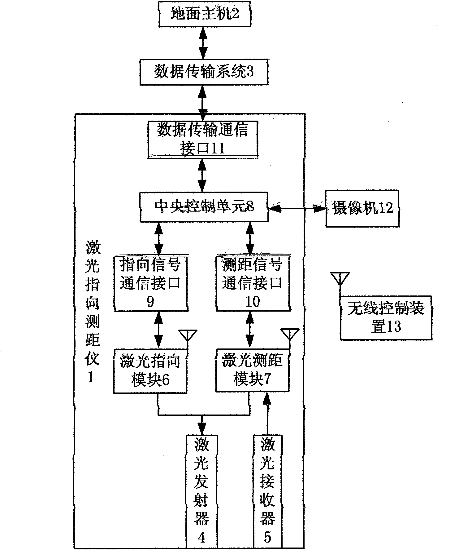
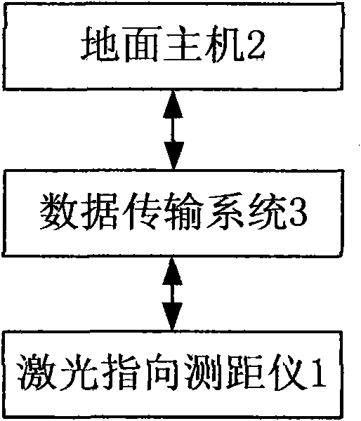
[0025] figure 1 Shown is the structural block diagram of safety pointing and safety distance real-time monitoring system of the present invention, and this system comprises laser pointing rangefinder 1, ground host 2 and the data transmission that is used for the communication between described laser pointing rangefinder and ground host System 3.

[0026] Such as figure 2 As shown, the laser pointing rangefinder can include a laser transmitter 4, a laser receiver 5, a laser pointing module 6 for controlling the laser transmitter to emit a pointing laser, and a laser pointing module 6 for controlling the laser transmitter to emit a distance measuring Laser is used to control the laser rangefinder module 7 of the laser receiver to receive reflected laser light, the central control unit 8 for controlling the work of the laser pointing module and the laser rangefinder module and performing data processing and for each module The power supply module for power supply and the cent...


PUM


Abstract

The invention relates to a safe pointing and safe distance real-time monitoring system which comprises a laser pointing distance measuring instrument, a ground host computer and a data transmission system, wherein the data transmission system is used for the communication between the laser pointing distance measuring instrument and the ground host computer. The laser pointing distance measuring instrument comprises a laser transmitter, a laser receiver, a laser pointing module, a laser distance measuring module, a central control unit, a communication module, a time control module and a power supply module, wherein the power supply module is used for supplying power for all the parts. The system is also provided with a video camera and a wireless control device. The invention can realize the automatic pointing in a tunneling direction and the automatic real-time monitoring of a tunneling distance, not only can save the manpower, but also can improve the production efficiency, and can realize the combined monitoring of data and images, the wireless control of a working spot and the remote control working of ground managers.

Description

technical field [0001] The invention relates to a system for pointing and ranging in tunnel and mine excavation engineering, in particular to an automatic control system capable of realizing safe pointing and safe distance monitoring. Background technique [0002] In coal mine excavation engineering, the excavation direction and excavation distance of the roadway are two important technical parameters related to engineering safety and engineering progress. For example, if the direction of the excavation is wrong, it will affect the progress of the project at least, and at the most, it will easily lead to false penetration of the multi-headed excavation of the roadway; if the excavation distance is not well controlled, it will easily cause dangers such as entering water areas, old empty areas, and gas outburst coal seams. The area puts the entire mine and personnel in a dangerous situation, and the inaccurate control of the water exploration position may cause floods, causing...

Claims


Application Information

Patent Timeline
IPC IPC(8): E21D9/00G01C15/00G01S17/08
Inventor 毛允德武立文
Owner BEIJING LONGDE SHIDAI TECH SERVICE
Why Eureka
Try Eureka