Method for predicting traffic flow extracted by improved C-V model-based remote sensing image road network

A technology of traffic flow and prediction method, which is applied in the field of traffic flow prediction based on the road network extraction of remote sensing map based on the improved C-V model, which can solve the problem of insufficient image segmentation speed, efficiency, accuracy, loss of color image color information, and difficulty in segmentation accuracy Guarantee and other issues to achieve the effect of speeding up the road network extraction process, realizing automatic acquisition, and reducing the amount of data processing

Inactive Publication Date: 2011-02-23
ZHEJIANG UNIV
View PDF3 Cites 18 Cited by
  • Summary
  • Abstract
  • Description
  • Claims
  • Application Information

AI Technical Summary

Problems solved by technology

However, the traditional level set C-V model has the following deficiencies: First, it needs to correct the initial curve in iterations, that is, re-initialize the signed distance function, which increases the amount of calculation, reduces the segmentation speed, and is difficult to guarantee the segmentation accuracy; The second is that the division of the region only considers the grayscale characteristics of the RGB space of the image, which

Method used


Image

  • Method for predicting traffic flow extracted by improved C-V model-based remote sensing image road network
  • Method for predicting traffic flow extracted by improved C-V model-based remote sensing image road network
  • Method for predicting traffic flow extracted by improved C-V model-based remote sensing image road network

Examples


Embodiment Construction

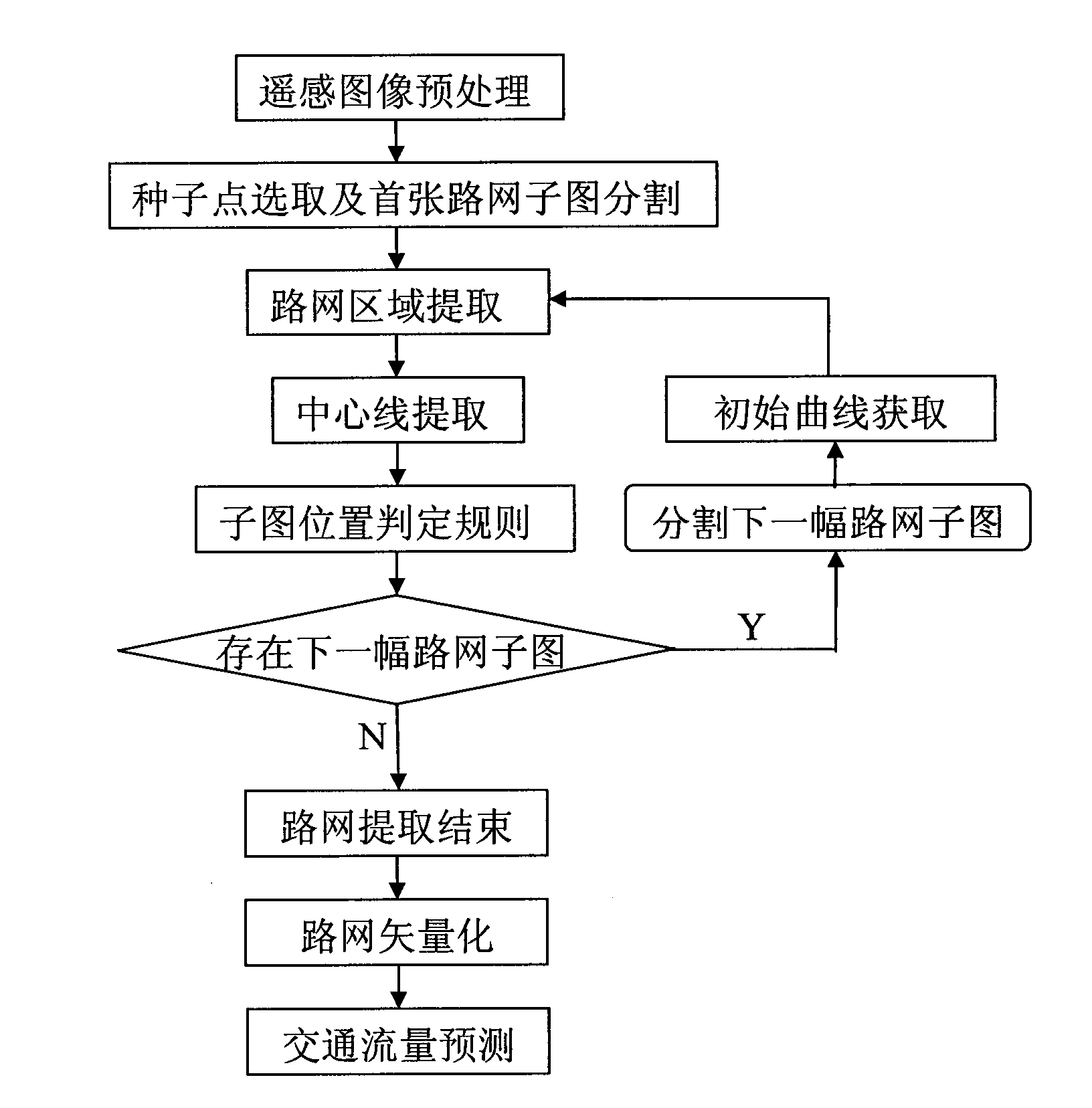
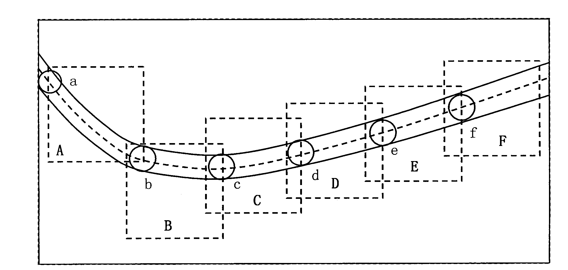
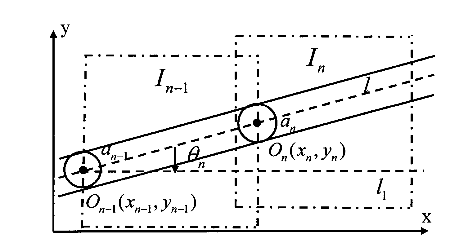
[0051] The present invention will be further described in detail below in conjunction with the drawings and specific embodiments.

[0052] The following takes the remote sensing image map (provided by QuickBird company, accuracy 0.61m) in Zhongshan City, Guangdong Province as an example to specifically illustrate the steps of the traffic flow prediction method of the present invention, and evaluate the road network extraction results with the integrity and correctness indicators.

[0053] In order to quantitatively evaluate the road network extraction algorithm, it is necessary to compare the road network area result (Estimate) extracted from the remote sensing image with the road network area result (GT) obtained from actual mapping, and introduce completeness (c) and correctness (p) Two indicators are evaluated. Equation (2) gives the definition of completeness (c) and correctness (p) respectively

[0054] c = | GT ∩ Estimate | | GT | X 100 % ...


PUM


Abstract

The invention discloses a method for predicting traffic flow extracted by an improved C-V model-based remote sensing image road network, which comprises the following steps of: (1) preprocessing an original remote sensing image; (2) selecting a seed point and segmenting a first road network sub-image; (3) extracting a road network area by an improved C-V model-based level set method; (4) extracting a road network central line by a morphological thinning method; (5) segmenting a next road network sub-image by using a sub-image position decision rule and automatically acquiring a road network initial curve in the road network sub-images by a threshold segmentation and morphological method; (6) vectorizing a road network; and (7) predicting the traffic flow. By integrating technology such as remote sensing, geographic information system (GIS), image identification, traffic planning and the like, an urban road network can be more accurately, efficiently and cheaply updated in real time, the traffic flow prediction cost is lower, the traffic flow prediction accuracy is higher and the traffic flow prediction period is shorter, so that decision makers can be effectively assisted in making traffic planning decisions.

Description

Technical field [0001] The present invention relates to the three major fields of high-resolution satellite remote sensing image processing and information extraction application, geographic information system, and traffic planning, and specifically relates to the use of image recognition technology to achieve road network extraction, traffic prediction technology to achieve traffic flow prediction, and geographic information system Realize thematic map production such as map management and flow. Background technique [0002] With the rapid development of my country's social economy, the process of urbanization continues to accelerate, the urban population and the number of motor vehicles continue to increase, and the contradiction between transportation demand and urban road conditions and capabilities has become increasingly prominent. At present, traffic congestion in many cities in my country and the resulting social problems such as traffic accidents and traffic environmenta...

Claims


Application Information

Patent Timeline
IPC IPC(8): G06K9/54G08G1/065
Inventor 储海兵侯迪波唐晓芬黄平捷张光新
Owner ZHEJIANG UNIV
Why Eureka
Try Eureka