Eureka AIR delivers breakthrough ideas for toughest innovation challenges, trusted by R&D personnel around the world.

Method and system for evaluating dam-break risk of dammed lake based on negotiable and cooperative work flow

A technology for risk assessment and collaborative work, applied in instruments, data processing applications, computing, etc., can solve problems such as low degree of informatization, poor visualization, and low evaluation efficiency, and achieve high execution efficiency, simple methods, and improved work. The effect of efficiency

Inactive Publication Date: 2011-04-27
SOUTHWEST JIAOTONG UNIV
View PDF0 Cites 4 Cited by
  • Summary
  • Abstract
  • Description
  • Claims
  • Application Information

AI Technical Summary

Problems solved by technology

[0003] 1) There is a lack of a clear and unified barrier lake outburst risk assessment process, and it is difficult to meet the accuracy and depth required for barrier lake outburst risk assessment in complex situations. Moreover, most of the existing work is done manually, and the degree of informatization is not high, and the assessment efficiency is low. Low, it may lead to errors in severe cases
[0004] 2) Lack of shared collaboration, it is difficult to effectively support multi-user collaboration
Collapse risk assessment requires multi-person, multi-field, multi-department collaboration and knowledge sharing to effectively solve problems. However, the existing decentralized combat mode is difficult to ensure effective knowledge sharing and collaboration to quickly solve complex geographic problems
[0005] 3) The degree of visualization is poor, resulting in low cognitive efficiency, and the time-consuming spatial analysis of complex relationships makes it difficult to quickly support cognition and data mining, and affects the accuracy of results
[0006] 4) The spatio-temporal analysis function is weak, and it is difficult to reflect the dynamic change process
Existing spatial analysis functions only include traditional functions such as roaming, distance measurement, area measurement, volume measurement, fixed-point query or simple GIS thematic map overlay, but the spatiotemporal analysis of the flood evolution process and its changing trend is relatively weak
However, the existing methods of simulation and prediction analysis of the geological process of barrier lake outburst are lacking, and most of them focus on the statistical analysis of historical data and empirical judgment, or use a single method for risk analysis, and there are few studies on the combination of quantitative and qualitative risk assessment.

Method used


Image

  • Method and system for evaluating dam-break risk of dammed lake based on negotiable and cooperative work flow
  • Method and system for evaluating dam-break risk of dammed lake based on negotiable and cooperative work flow
  • Method and system for evaluating dam-break risk of dammed lake based on negotiable and cooperative work flow

Examples


Embodiment Construction

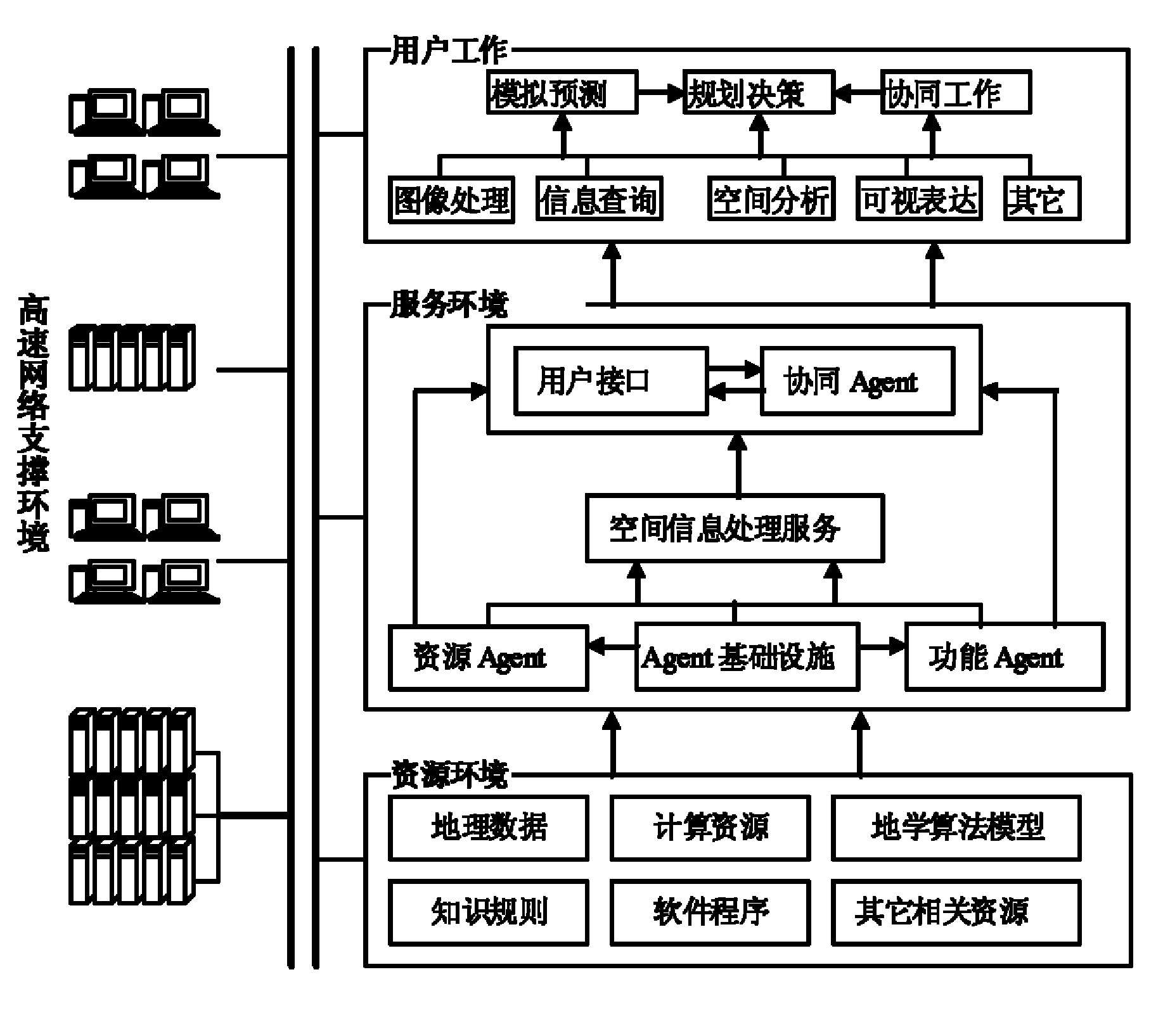
[0015] Service framework architecture design such as figure 1 As shown, a distributed framework structure based on a four-layer system is adopted, including network support layer, resource layer, service layer, and user layer. Among them, the network support layer is the software and hardware technical support environment built by the spatial information service system, and is the physical carrier and premise of the system realization; the resource layer realizes the integration and sharing of various spatial data, computing resources, geoscience algorithm models, software programs, etc. The basis for the establishment of the spatial information system; the service layer is responsible for the scheduling and management of the entire system, maintains the smooth and efficient operation of the system, maintains the collaboration of each node, and provides users with a unified interface and collaborative management services. It is the core part of the entire framework. Service-ce...


PUM


Abstract

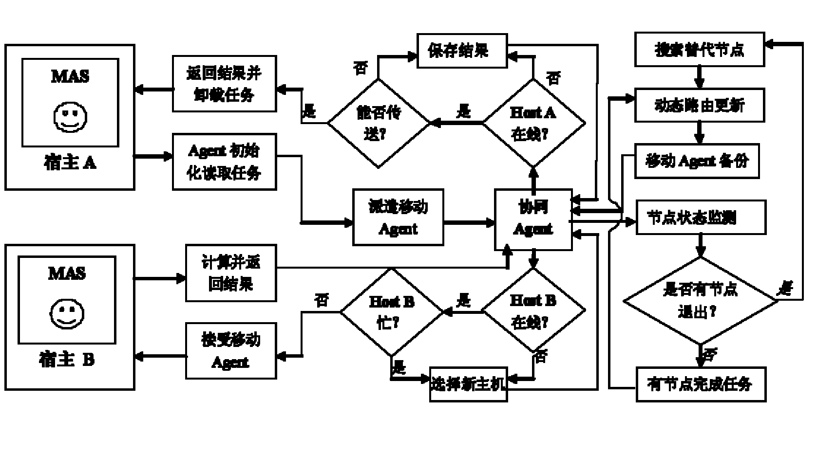
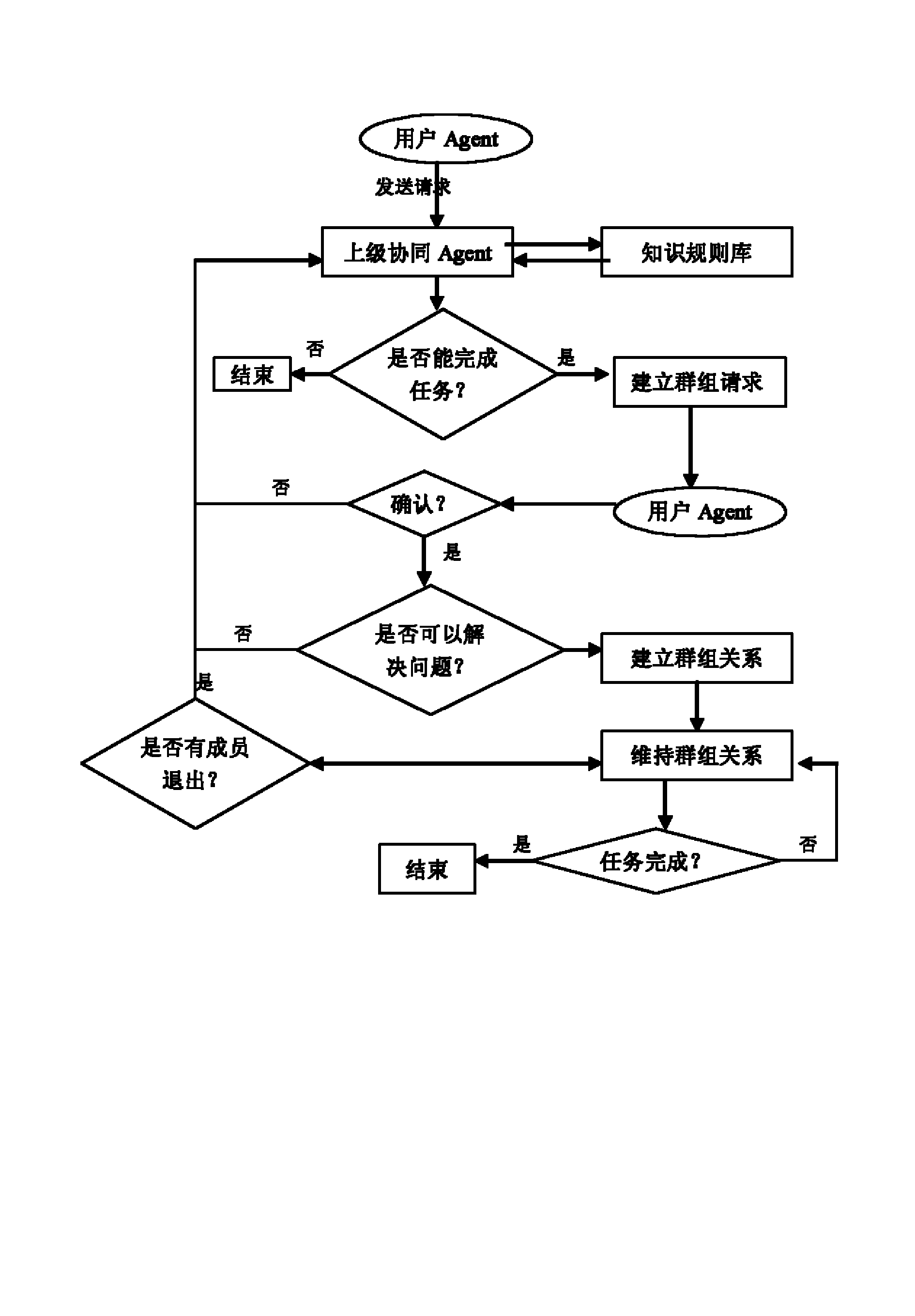
The invention discloses a method and system for evaluating the dam-break risk of a dammed lake based on a negotiable and cooperative work flow, which are used for the negotiable and cooperative evaluation of the dam-break simulation and influence analysis of the dammed lake. The system is characterized in that a distributed frame based on a four-layer system is adopted. The system consists of three parts: a moving Agent, an AgentHost and a cooperative Agent. In the invention, the centralized decision and treatment of disaster negotiation information are accomplished by providing cooperative virtual work environment of multiple point in different places, command and decision makers and related personnel at all levels in different regions can cooperatively communicate to share and exchange disaster information and take part in discussion about the dam-break simulation and the influence analysis of the dammed lake together, and the cooperative analysis and the evaluation of the dam-break risk of the dammed lake are achieved. The invention has the advantages of simple method and high execution efficiency, is suitable for multiple users distributed in different places to carry out negotiable and cooperative evaluation, and can effectively improve the work efficiency of the dam-break risk evaluation of the dammed lake.

Description

technical field [0001] The invention belongs to the research fields of geographic collaboration technology, geographic information system, geoscience visualization and virtual geographic environment. Background technique [0002] Due to the complexity of the barrier lake problem, many uncertain factors are involved, and the collapse event has the characteristics of sudden occurrence, rapid expansion, decentralized processing part, and urgency of response requirements. Existing evaluation methods have some drawbacks: [0003] 1) There is a lack of a clear and unified barrier lake outburst risk assessment process, and it is difficult to meet the accuracy and depth required for barrier lake outburst risk assessment in complex situations. Moreover, most of the existing work is done manually, and the degree of informatization is not high, and the assessment efficiency is low. Low, it may lead to errors in severe cases. [0004] 2) Lack of sharing and collaboration, it is diffic...

Claims


Application Information

Patent Timeline
IPC IPC(8): G06Q10/00G06Q50/00
Inventor 朱军胡亚胡良喜马嵩李毅吴忠俊周洁萍
Owner SOUTHWEST JIAOTONG UNIV
Why Eureka
Eureka Blog
Learn More