Global positioning system (GPS) and machine vision-based integrated navigation and positioning system and method

A GPS positioning and machine vision technology, applied in the field of navigation and positioning, can solve the problems of unsuitable real-time operations in the field, poor real-time processing performance of algorithms, and high dimension of texture eigenvalues, so as to facilitate operations such as data dumping and data query. Program-friendly, jump-improved effect

Inactive Publication Date: 2011-11-23
CHINA AGRI UNIV
View PDF4 Cites 67 Cited by
  • Summary
  • Abstract
  • Description
  • Claims
  • Application Information

AI Technical Summary

Problems solved by technology

However, due to the relatively high dimensionality of texture feature values, a relatively large amount of calculation is requir...

Method used


Image

  • Global positioning system (GPS) and machine vision-based integrated navigation and positioning system and method
  • Global positioning system (GPS) and machine vision-based integrated navigation and positioning system and method
  • Global positioning system (GPS) and machine vision-based integrated navigation and positioning system and method

Examples


Embodiment Construction

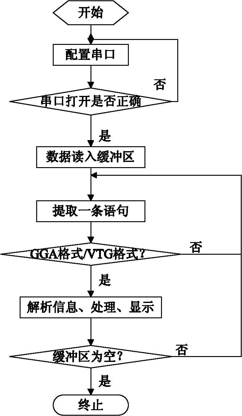
[0042] The integrated navigation and positioning system and method based on GPS and machine vision proposed by the present invention are described in detail below in conjunction with the accompanying drawings and embodiments.

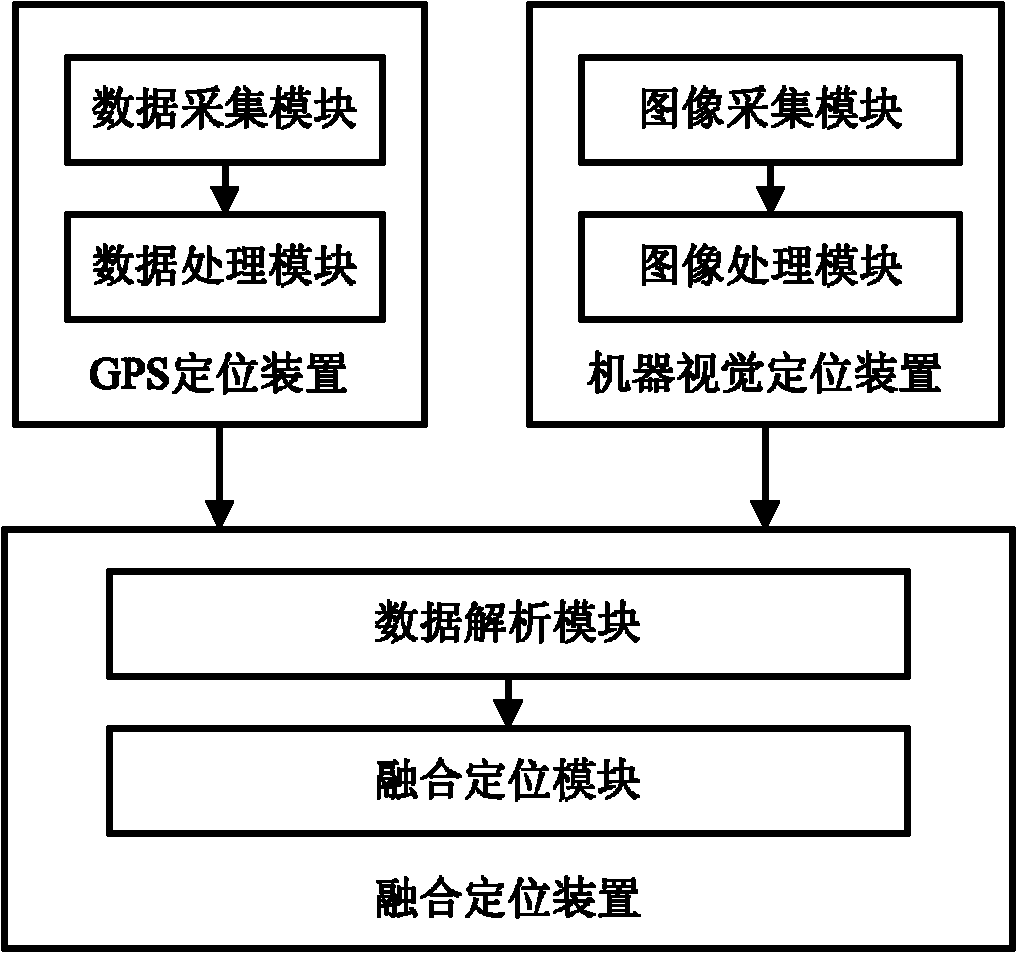
[0043] The boundary between harvested and unharvested crops in the farmland is sometimes not a straight line. Using GPS alone for navigation has certain errors in determining the navigation reference line; machine vision can extract the characteristic information of the current crop row in real time when performing such operations, which improves the Positioning accuracy, but when machine vision is used alone, sometimes missed detection occurs during image processing, so the present invention combines GPS and camera sensors for navigation.

[0044] Such as figure 1 As shown, the integrated navigation and positioning system based on GPS and machine vision according to an embodiment of the present invention includes:

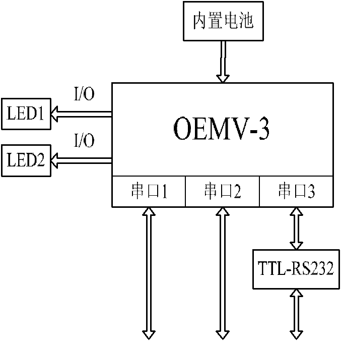
[0045]The GPS positioning device pe...


PUM


Abstract

The invention discloses a global positioning system (GPS) and machine vision-based integrated navigation and positioning system and a method. The system comprises a GPS positioning device which is utilized for carrying out GPS positioning process on a navigated vehicle, acquiring position coordinates, course angles and driving speed of the navigated vehicle and transmitting the acquired information to a fusion positioning device, a machine vision positioning device which is utilized for collecting images of farmland on a navigation path, carrying out image processing on the collected images, extracting the navigation path to obtain position coordinates of known points on the navigation path, and transmitting the position coordinates to the fusion positioning device, and the fusion positioning device which is utilized for carrying out spatial adjustment and temporal adjustment processes on information from the GPS positioning device and the machine vision positioning device and carrying out filtering processing to obtain final positioning information. The method and the system provided by the invention have the advantages of high positioning accuracy, simple operations and good applicability for real-time operation in field.

Description

technical field [0001] The invention relates to the technical field of navigation and positioning, in particular to a combined navigation and positioning system and method based on GPS and machine vision. Background technique [0002] Precision agriculture includes positioning prescription farming and automatic collection of agricultural information. Positioning prescription farming requires that agricultural machinery can walk in the field according to a pre-planned path, accurately reach the destination and complete the established tasks. Precise navigation is one of the key technologies to realize autonomous walking of agricultural machinery, and its positioning accuracy directly affects the quality of automatic path tracking of agricultural machinery. Therefore, improving the accuracy of navigation and positioning is the primary issue to improve the quality of agricultural machinery path tracking. [0003] Global Positioning System (Global Positioning System, GPS) navig...

Claims


Application Information

Patent Timeline
IPC IPC(8): G01C21/26G01S19/39
Inventor 张漫陈艳刘兆祥籍颖马文强吴琼刘刚
Owner CHINA AGRI UNIV
Why Eureka
Try Eureka