Three-dimensional roof reconstruction method based on LiDAR data and ortho images

An orthophoto and data technology, applied in the field of 3D roof reconstruction based on LiDAR data and orthophoto, can solve the problems of modeling accuracy dependence, limited accuracy, difficulty in matching feature selection, etc., to achieve completeness and positioning accuracy High, correctness and integrity are high, the effect of preserving edge information

Inactive Publication Date: 2012-06-27
NANJING UNIV
View PDF0 Cites 45 Cited by
  • Summary
  • Abstract
  • Description
  • Claims
  • Application Information

AI Technical Summary

Problems solved by technology

Image-based automatic reconstruction is currently the most economical and efficient modeling method for urban buildings, but this method has certain problems: (1) Image data contains a lot of shadows and noise, and the related processing of noise is not very mature; ( 2) The selection of image pair matching features is difficult; (3) Reconstruction of 3D models from images using photogrammetry is a comprehensive and complex problem, and complete automatic extraction is not realistic
However, since the LiDAR point spacing is about one meter and the accuracy is limited, the contour obtained by the initial patch segmentation cannot be an accurate contour. To solve this problem, the regularization method is often used at present, but there are certain problems in the regularization method: ( 1) The construction of the initial patch may not be completely accurate, and the appearance of local concave-convex polygons may cause redundant polygons or loss of local features in the regularized result; (2) The regularization of a single patch, the topology of each patch The consideration of the relationship is lacking, and such regularization can easily lead to the offset of the contour line
This method can correct the edge of the building very well, but the accuracy of the modeling depends largely on the accuracy of the image segmentation, and it fails to take full advantage of the data advantages of LiDAR points

Method used


Image

  • Three-dimensional roof reconstruction method based on LiDAR data and ortho images
  • Three-dimensional roof reconstruction method based on LiDAR data and ortho images
  • Three-dimensional roof reconstruction method based on LiDAR data and ortho images

Examples


Embodiment

[0051] to attach Figure 4 Shown are LiDAR data and orthophotos of two experimental areas as examples. Orthophoto data resolution is 5cm, LiDAR data represents different elevations with different gray values, the average point spacing is 1m, the elevation accuracy is 15cm, and the plane accuracy is about 30cm. The experimental area contains multiple buildings with different roof structures, orientations, and complexity.

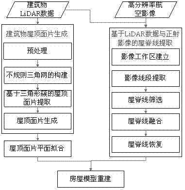
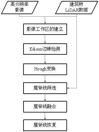
[0052] Refer to the three steps described in the technical solution to process LiDAR data and orthophotos. The specific process steps are as follows:

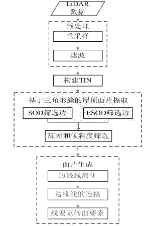
[0053] Step 1: LiDAR point roof patch segmentation based on triangle clusters

[0054] (1) Preprocessing the LiDAR data, including resampling and filtering.

[0055] ① Resampling

[0056] Commonly used resampling methods include nearest neighbor method, bilinear interpolation method and cubic convolution method, but these three methods are not suitable for LiDAR data. Resampling by the nearest neighbor ...


PUM


Abstract

The invention belongs to the field of image processing methods, and discloses a three-dimensional roof reconstruction method based on LiDAR data and ortho images. The method comprises the following steps of: (1) LiDAR point roof facets segmentation based on a triangular cluster; (2) roof ridge extraction based on LiDAR data nad ortho images; (3) three-dimensional roof model reconstruction. In the method, for meeting the requirement on accurate reconstruction of the three-dimensional roof model, the LiDAR data and the high-resolution images are integrated, the complementary advantages of the elevation characteristic of the LiDAR data and the high-resolution characteristic of the images are comprehensively used, 'roof facets segmentation, ridge extracton and three-dimensional roof model reconstruction' is taken as a principal line, a LiDAR point roof facets segmentation algorithm based on the triangular cluster and a roof ridge extraction algorithm based on the LiDAR data and the ortho images are realized, and a new method for three-dimensional roof model reconstruction is formed. Tests show that the method of the invention has high automation degree, higher accuracy and integrity and high location precision in modeling, and meets the needs of actual application.

Description

technical field [0001] The method belongs to the technical field of image processing methods, and in particular relates to a high-precision and automatic 3D roof reconstruction method based on the combination of LiDAR data and orthophoto images. Background technique [0002] 3D architectural model is an important part of digital city, widely used in surveying and mapping remote sensing, virtual reality, urban planning, scientific research and other fields. Constructing 3D architectural models through manual digitization and 3D manual modeling is inefficient and costly, and it is difficult to meet the needs of large-scale, real-time architectural models. With the development of photogrammetry technology, image processing technology, computer vision technology, geographic information technology and other disciplines, various building model construction methods are emerging. These methods can be mainly divided into automatic reconstruction methods based on images, automatic rec...

Claims


Application Information

Patent Timeline
Patent Type & Authority Applications(China)
IPC IPC(8): G06T17/10
Inventor 程亮李满春刘永学童礼华张雯陈焱明蔡文婷李真杨康潘航邹伟
Owner NANJING UNIV
Why Eureka
Try Eureka