Extreme-low-altitude laser radar digital terrain mapping system and extreme-low-altitude laser radar digital terrain mapping method of small-sized unmanned helicopter

An unmanned helicopter and lidar technology, applied in radio wave measurement systems, measurement devices, and re-radiation of electromagnetic waves, etc., can solve the problems of large equipment, changing flight routes, and heavy weight.

Active Publication Date: 2013-02-13
SOUTH CHINA UNIV OF TECH
View PDF4 Cites 25 Cited by
  • Summary
  • Abstract
  • Description
  • Claims
  • Application Information

AI Technical Summary

Problems solved by technology

At present, most of the airborne lidar systems in operation are large-scale airborne systems, which generally work at high altitudes. The equipment is large in size and heavy in weight, and is easily affected by airspace control and weather.
Th

Method used


Image

  • Extreme-low-altitude laser radar digital terrain mapping system and extreme-low-altitude laser radar digital terrain mapping method of small-sized unmanned helicopter
  • Extreme-low-altitude laser radar digital terrain mapping system and extreme-low-altitude laser radar digital terrain mapping method of small-sized unmanned helicopter
  • Extreme-low-altitude laser radar digital terrain mapping system and extreme-low-altitude laser radar digital terrain mapping method of small-sized unmanned helicopter

Examples


Embodiment

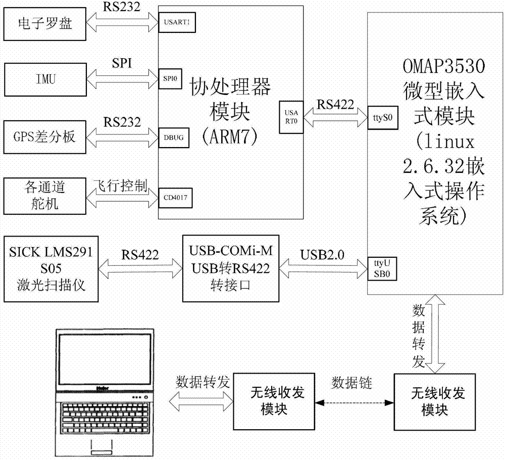
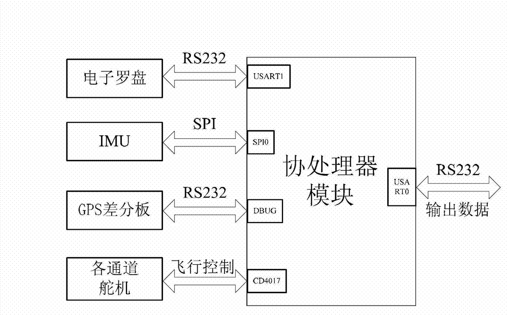
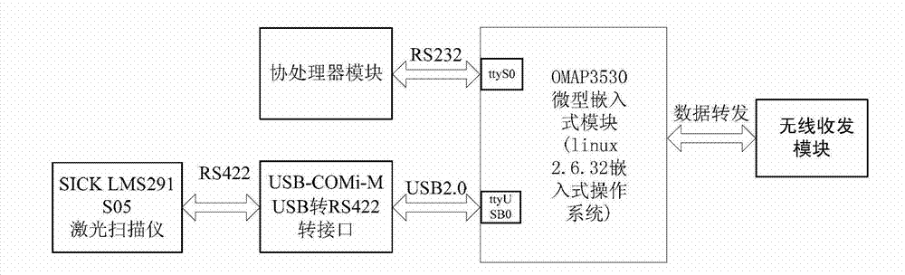
[0049] Such as figure 1 As shown, the overall architecture of the ultra-low-altitude airborne lidar digital terrain mapping system based on a small unmanned helicopter in this embodiment includes two parts: the ground station system and the airborne system. In order to build a practical light and small system, on the basis of fully guaranteeing the normal working time and accuracy of the system, select the sensor device with light weight, small size and low power consumption. The ground station system consists of two parts: portable computer server and wireless communication equipment. The airborne system includes laser range finder and data conversion module, battery and power supply system, GPS differential board and base station data wireless receiving module, sensor data acquisition system, main controller and wireless communication module.

[0050] The airborne system is mainly responsible for the correct collection of sensor data, synchronous processing of sensor data a...


PUM


Abstract

The invention discloses an extreme-low-altitude laser radar digital terrain mapping system and an extreme-low-altitude laser radar digital terrain mapping method of a small-sized unmanned helicopter. The system is formed by an airborne system and a ground station system, wherein the airborne system is used for accurately collecting data of each sensor, carrying out synchronization processing on the data of the sensors and navigation control of the unmanned helicopter, and can realize data interaction with data of the ground station system through wireless receiving and dispatching equipment; the ground station system is used for receiving and processing data from an airborne laser radar hardware system or checking and processing a data file in an offline manner; the airborne system is formed by a coprocessor and a main processor; and the coprocessor is used for collecting gesture data and position data of the system or realizing the navigation control of the airborne system. According to the extreme-low-altitude laser radar digital terrain mapping system, a mode of matching the coprocessor with the main processor is utilized so that the requirements of the instantaneity and the stability of the navigation control of the small-sized unmanned helicopter are guaranteed, the system is flexible and the function of the airborne system is conveniently expanded; and the system has the advantages of low power consumption, low cost, high integration, high efficiency and the like.

Description

technical field [0001] The invention relates to the technical field of terrain surveying and mapping, in particular to an ultra-low-altitude digital terrain surveying and mapping system and method for a small unmanned helicopter that can realize full-automatic, non-contact and dynamic real-time. Background technique [0002] Airborne lidar technology is an emerging measurement technology that integrates high-precision dynamic DGPS technology, laser ranging technology, high-precision carrier attitude measurement technology and computer technology. The range information obtained by the laser rangefinder combined with the attitude information obtained by the attitude measurement module and the position information obtained by high-precision differential GPS can be solved to obtain accurate three-dimensional coordinates of objects and high-resolution digital terrain models. It provides a new type of remote sensing technology method for people to continuously and automatically ac...

Claims


Application Information

Patent Timeline
IPC IPC(8): G01S17/89
Inventor 裴海龙吴文升
Owner SOUTH CHINA UNIV OF TECH
Why Eureka
Try Eureka