
Indoor simultaneous locating and environment modeling method for unmanned aerial vehicle

A technology of unmanned aerial vehicle and indoor environment, which is applied in the field of robot indoor positioning and three-dimensional environment modeling, which can solve the problems of slight vibration, error, large error in motion calculation, etc., and achieve the effect of saving time, good controllability and strong flexibility

Inactive Publication Date: 2014-07-16
BEIHANG UNIV
View PDF4 Cites 56 Cited by
  • Summary
  • Abstract
  • Description
  • Claims
  • Application Information

AI Technical Summary

Problems solved by technology

[0007] 1) Limited load: As an aircraft, it needs to provide uninterrupted lift to maintain its own balance, so the load is limited, and it is difficult to carry a variety of heavy sensors like ground robots
The acquisition of external environmental information is bound to have certain limitations.
[0008] 2) Limited computing power: The limited load determines that the unmanned aerial vehicle intelligently carries a lightweight embedded computer system, and the SLAM algorithm and online search strategy based on the unmanned aerial vehicle have high time complexity, while ensuring real-time The computing power of unmanned aerial vehicles is limited, so special optimization or redesign of related algorithms is necessary
[0009] 3) Action changes quickly: UAVs move very fast, and any delay may be amplified by this characteristic, resulting in greater errors. Therefore, each module of the system must ensure a certain degree of real-time performance
[0010] 4) Frequent vibrations: Unmanned aerial vehicles cannot stand still like ground robots, and will vibrate slightly in the air, which brings great difficulties to the planning work
[0011] 5) Three-dimensional space: Unmanned aerial vehicles operate in three-dimensional space. Some previous online search strategies for ground robots often face two-dimensional space, and three-dimensional space will increase the complexity of the state space of the agent.
[0013] 7) Relative position estimation: In order to realize the indoor search strategy of UAVs, accurate indoor positioning is required. The odometry method based on ground robots can directly obtain relative position estimates for positioning, but the inertial measurement unit on UAVs is light. Quantitative, the movement calculation error is relatively large, and it cannot be used directly
[0014] From the above, it can be seen that there are still great challenges and research prospects for indoor exploration and modeling on UAVs, which is of great scientific significance.

Method used


Image

  • Indoor simultaneous locating and environment modeling method for unmanned aerial vehicle
  • Indoor simultaneous locating and environment modeling method for unmanned aerial vehicle
  • Indoor simultaneous locating and environment modeling method for unmanned aerial vehicle

Examples


Embodiment Construction

[0034] The technical solution of the present invention will be further described in detail below in conjunction with the accompanying drawings.

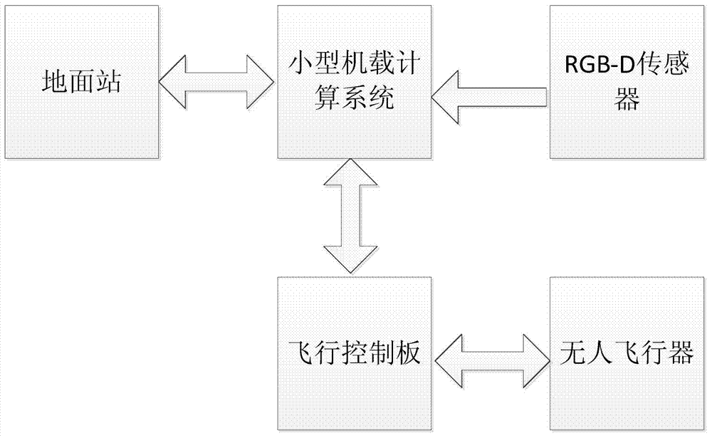
[0035] First, we pass figure 1 Carry out overall construction to the system hardware involved in the present invention. In the process of platform construction, the principle of minimum load should be followed to ensure that the unmanned aerial vehicle can obtain a relatively stable and flexible flight attitude in the indoor space, so that we can carry out the next data collection and calculation work.

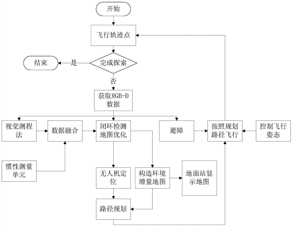
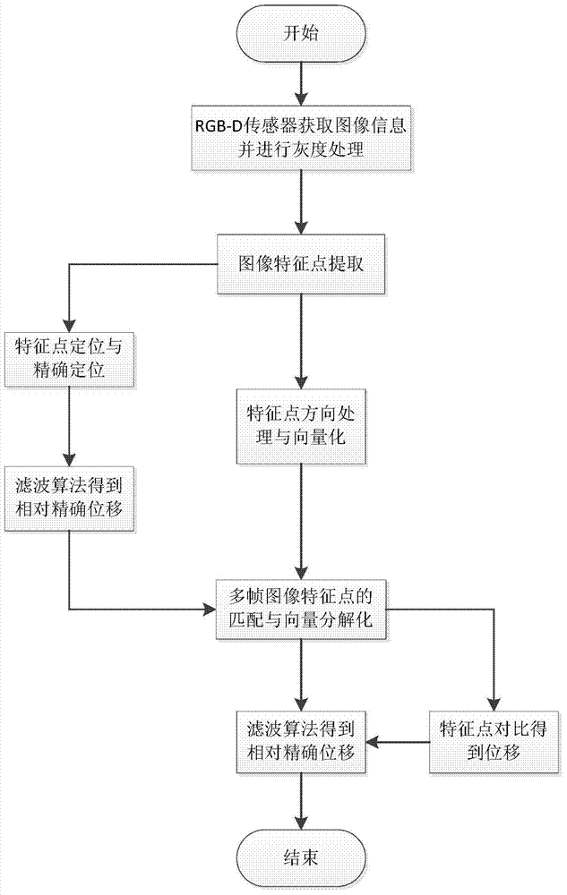
[0036] next use figure 2 The system software framework shown builds the UAV software system, uses the RGB-D sensor mounted on it to collect external data, and uses the visual odometry method to calculate and filter the route trajectory and displacement of the UAV flying indoors , so as to obtain relatively more accurate flight data of the aircraft. Furthermore, we use the data transmission function of the unmanned aerial vehicle ...


PUM


Abstract

The invention discloses an indoor simultaneous locating and environment modeling method for an unmanned aerial vehicle. According to the method, flying tracks of the unmanned aerial vehicle can be located, and an indoor three-dimensional environmental model can be drawn fast. An operation platform and an operation method of the unmanned aerial vehicle are constructed, an RGB-D sensor carried by the unmanned aerial vehicle is utilized for collecting data, a visual odometry is adopted for estimating the indoor flying tracks and positions of the unmanned aerial vehicle, and an extended kalman filtering algorithm is adopted for obtaining the more accurate flying tracks and the positions of the aerial vehicle. Furthermore, the data transmission functions of the unmanned aerial vehicle and a ground communication device are utilized for feeding information collected by the sensor on the aerial vehicle back to ground operating personnel in real time, and a three-dimensional data display method of a computer is utilized for calculating and processing the collected data and carrying out indoor three-dimensional environment modeling and displaying.

Description

technical field [0001] The invention belongs to the field of artificial intelligence and computer vision, and in particular relates to indoor positioning of a robot and a three-dimensional environment modeling method. Background technique [0002] With the continuous development of intelligent robot research, it has gradually become possible to use robots instead of humans to explore and model the environment. The key issues that need to be addressed are indoor localization and environment modeling methods for robots. [0003] At present, most of the robot platforms studied and experimented by researchers are ground robots, such as smart cars, humanoid robots and other functional robots. These researches have achieved certain results, covering many fields such as artificial intelligence and image recognition. However, for some specific environments, it is difficult to complete the task of exploring the environment only by ground robots. The environment in which the robot l...

Claims


Application Information

Patent Timeline
IPC IPC(8): G05D1/10G05B13/04
Inventor 丁嵘陈震王顺利朱骋朱润凯
Owner BEIHANG UNIV
Learn More