GIS (Geographic Information System) platform-based urban water system construction planning method

A water system and planning technology, applied in special data processing applications, instruments, climate change adaptation, etc., can solve problems such as being too specialized, lack of research and integration of related tools, and difficult to combine related analysis of water system planning work. Intuitive effect of analysis results

Active Publication Date: 2014-07-30
TIANJIN UNIV CITY PLANNING & DESIGN INST
View PDF3 Cites 36 Cited by
  • Summary
  • Abstract
  • Description
  • Claims
  • Application Information

AI Technical Summary

Problems solved by technology

[0002] At present, GIS spatial analysis technology has been partially applied in the field of urban water system planning and management. Using some tools in the spatial analysis tool (Spatial Analyst tool) under the ArcGIS platform can provide relatively shallow surface hydrological analysis technology support, which is only limited at this stage. Due to single functions such as watershed division management and surface runoff analysis, there is a lack of in-depth research and relevant tool integration at the level of water

Method used


Image

  • GIS (Geographic Information System) platform-based urban water system construction planning method
  • GIS (Geographic Information System) platform-based urban water system construction planning method
  • GIS (Geographic Information System) platform-based urban water system construction planning method

Examples


Embodiment

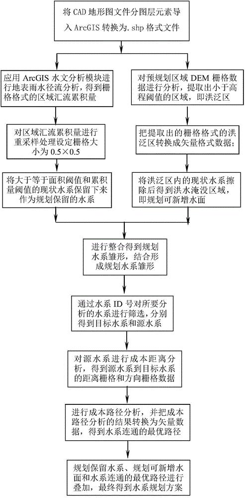
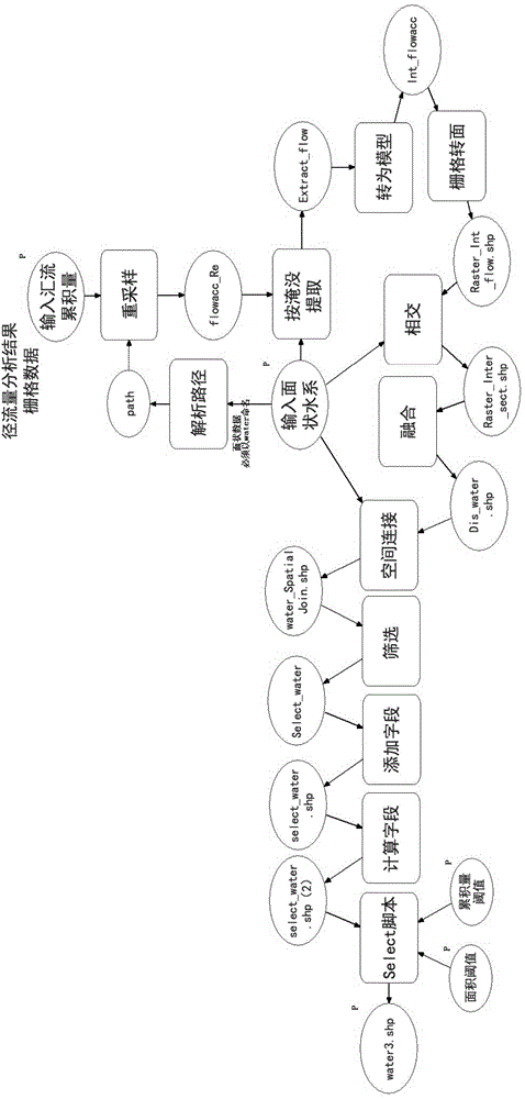
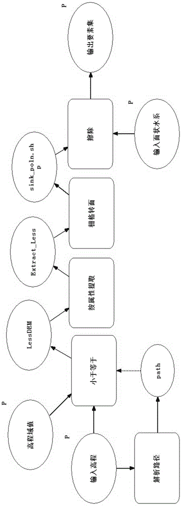
[0074] (1) Extract the contour line and elevation point elements in the regional CAD topographic map by layer, and use ArcGIS10.0 to convert them into shape format files; extract the limiting factor elements in the regional CAD topographic map by layer, including roads, Vegetation, built-up land and elements such as high-voltage corridors and water sources (two reservoirs) were converted into shape format files using ArcGIS10.0.

[0075] (2) Use the 3D Analyst tool in ArcGIS10.0 software to create a TIN (Irregular Triangular Network), and finally convert and generate an elevation data file (DEM) in a raster format.

[0076] (3) Close the current water system curve in the regional CAD topographic map, import it into ArcGIS to form a surface water system file in shape format, combine the current vegetation, human activities, etc., use the Euclidean distance analysis tool to perform buffer analysis on the three, and then follow Scoring criteria from 1 to 10 (1 represents little h...


PUM


Abstract

The invention discloses a GIS (Geographic Information System) platform-based urban water system construction planning method, which is integrated with a spatial analysis tool under the ArcGIS platform to form a complete set of analysis method suitable for water system planning. The GIS platform-based urban water system construction planning method mainly comprises the following three parts: (1) screening and analysis tool for existing water systems: according to the distribution and runoff of existing water systems, the water systems which reach certain area and accumulated runoff are screened out; (2) flood inundation analysis tool: extraction and analysis are carried out, and possible flooded areas are calculated; iteration is carried out with the screened existing water systems, and flooded areas outside the scopes of the existing water systems are calculated; (3) water system connectivity analysis tool: according to cost data, optimal route analysis is carried out on the connectivity of a plurality of pairs of areal water systems in a map layer. The integration of the three parts effectively solves the problem on how to sort existing water systems in urban planning work, construct new water areas and connect water systems, and finally, a complete set of analysis tool which is highly efficient and suitable for water system planning is formed.

Description

technical field [0001] The invention relates to a method for constructing and planning an urban water system, in particular to a method for constructing and planning an urban water system based on a GIS platform. Background technique [0002] At present, GIS spatial analysis technology has been partially applied in the field of urban water system planning and management. Using some tools in the spatial analysis tool (Spatial Analyst tool) under the ArcGIS platform can provide relatively shallow surface hydrological analysis technology support, which is only limited at this stage. Due to single functions such as watershed division management and surface runoff analysis, there is a lack of in-depth research and relevant tool integration at the level of water system planning and design in the field of urban planning. [0003] Many water resources allocation models for hydrological analysis have been developed based on the ArcGIS platform at home and abroad, but most of them are...

Claims


Application Information

Patent Timeline
IPC IPC(8): G06F17/50
CPCY02A10/40
Inventor 王卫红洪再生潘睿智雷璇杜津
Owner TIANJIN UNIV CITY PLANNING & DESIGN INST
Why Eureka
Try Eureka