Soil water content measuring method based on ultra wideband radar

A technology of ultra-wideband radar and soil water content, applied in the field of soil water content measurement based on ultra-wideband radar

Active Publication Date: 2014-09-24
UNIV OF ELECTRONICS SCI & TECH OF CHINA
View PDF2 Cites 22 Cited by
  • Summary
  • Abstract
  • Description
  • Claims
  • Application Information

AI Technical Summary

Problems solved by technology

[0008] Aiming at the current method of measuring soil moisture (water content) parameters, the present invention provides a method for establishing the corresponding relationship between soil moisture and ultra-wideband radar signal parameters, and obtaining the target soil moisture according to the corresponding relationship. After the present invention realizes networking Large-scale real-time soil monitoring can be carried out to promote the development of precision agriculture in China

Method used


Image

  • Soil water content measuring method based on ultra wideband radar
  • Soil water content measuring method based on ultra wideband radar
  • Soil water content measuring method based on ultra wideband radar

Examples


Embodiment 1

[0038] What the present invention provides is a kind of soil water content measurement method based on ultra-wideband radar, mainly adopts following method:

[0039] 1) Delineate the soil test area, uniformly set no less than 10 sampling points in the test area, and use the existing precise measuring instruments for measuring individual soil parameters to collect the soil humidity parameters respectively;

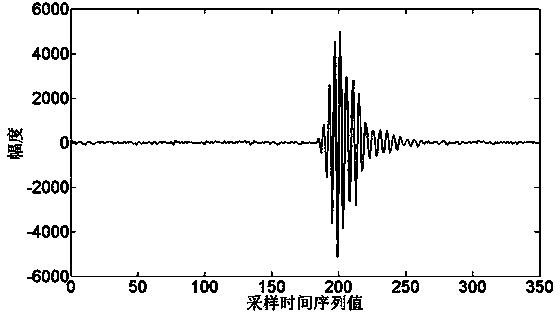
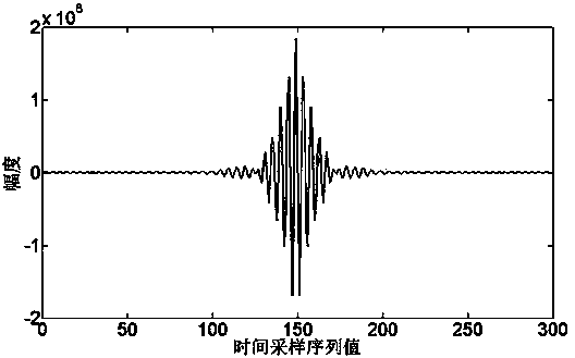
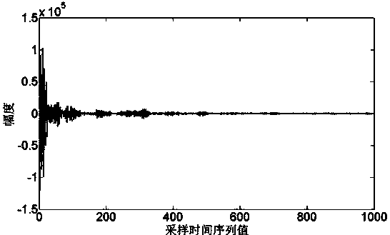
[0040] 2) Use the UWB radar sensor to collect the time-domain signals of the soil echo at each sampling point in the test area;

[0041] 3) For the echo signal collected at the sampling point, the time-domain method of wireless multi-path channel impact estimation is used to extract the multi-path channel, and the parameter estimation algorithm is used to estimate the parameter distribution model of the multi-path channel such as amplitude and time delay, and a mathematical statistical model is obtained parameters, select the best parameter estimation results, determine the...

Embodiment 2

[0045] A method for measuring soil moisture based on ultra-wideband radar, comprising the following:

[0046] 1. Test equipment

[0047]The ultra-wideband radar used in this method is Time Domain’s PulseON 410 single base station radar to collect data. The main components include: two ultra-wideband Broadspec annular dipole transceiver antennas, a radar module (MRM), radar self-configured power supply, computer and others Auxiliary accessories. The radar module generates an ultra-wideband signal with a frequency of 3.1GHz to 5.3GHz, a center frequency of 4.3GHz, and a bandwidth of 2GHz. The late ultra-wideband radar echo data processing uses MATLAB software.

[0048] 2. Test steps

[0049] (1) For the measurement of large-scale soil moisture content, first select the time delay point, and divide the test area into 10 small blocks on average. In each small block, use a soil moisture meter to measure the humidity of the soil surface, and use an ultra-wideband radar to collect...


PUM


Abstract

The invention provides a soil water content measuring method based on an ultra wideband radar, and belongs to the field of soil water content measuring. The soil water content measuring method based on the ultra wideband radar is provided for solving the problems that a traditional soil water content measuring method is poor in real-time performance, and the area of soil measured in a one-off mode is small. The soil water content measuring method based on the ultra wideband radar mainly includes the steps that the ultra wideband radar is adopted for collecting radar data to estimate an ultra wideband multi-path channel of the soil; parameters, such as the range and the delay spread, of the multi-path channel are analyzed, and statistical properties of the multi-path channel are analyzed; the relationship between water content and the statistical properties of the multi-path channel is set up; according to the corresponding relationship, the water content of the target soil is measured. According to the soil water content measuring method based on the ultra wideband radar, the soil water content can be accurately monitored in real time without destruction; the soil water content measuring method based on the ultra wideband radar is suitable for farmland, and particularly the soil can be monitored in real time in a large scale after networking is achieved.

Description

technical field [0001] The invention relates to a method for measuring soil water content parameters, in particular to a method for measuring soil water content based on ultra-wideband radar. Background technique [0002] Soil is the basis for implementing precision agriculture. With the rapid development of China's national economy, people discharge more and more pollutants into the soil, and soil pollution is becoming more and more serious. Soil information has the characteristics of large data volume, multi-dimensional distribution, large spatial distribution differences, and strong time-varying characteristics. In traditional agriculture, people have limited ways to obtain soil information, mainly through manual measurement. The acquisition process requires a lot of manpower and time, which cannot meet the needs of precision agriculture for timely information acquisition and multi-dimensional data, and will have a certain impact on the environment. Therefore, there is ...

Claims


Application Information

Patent Timeline
Patent Type & Authority Applications(China)
IPC IPC(8): G01S13/88G01N22/04
CPCG01N22/04G01S13/88
Inventor 梁菁刘淼胡耀月朱方启霍扬扬毛诚晨刘怀远
Owner UNIV OF ELECTRONICS SCI & TECH OF CHINA
Why Eureka
Try Eureka