Tree species classification method based on LiDAR (Light Detection and Ranging) false-vertical waveform model

A pseudo-vertical waveform and tree species classification technology, applied in the re-radiation of electromagnetic waves, radio wave measurement systems, and utilization of re-radiation, etc., can solve the problem of low classification accuracy, reduce labor and time consumption, and ensure space integrity and time. Consistency, the effect of reducing processing costs

Active Publication Date: 2014-11-19
NANJING FORESTRY UNIV
View PDF1 Cites 24 Cited by
  • Summary
  • Abstract
  • Description
  • Claims
  • Application Information

AI Technical Summary

Problems solved by technology

However, the above methods are only suitable for the classification of forests with a single tree species (such as pure forest) or relati

Method used


Image

  • Tree species classification method based on LiDAR (Light Detection and Ranging) false-vertical waveform model
  • Tree species classification method based on LiDAR (Light Detection and Ranging) false-vertical waveform model
  • Tree species classification method based on LiDAR (Light Detection and Ranging) false-vertical waveform model

Examples


Embodiment 1

[0045] A kind of tree species classification method based on LiDAR pseudo-vertical waveform model, comprises the following steps:

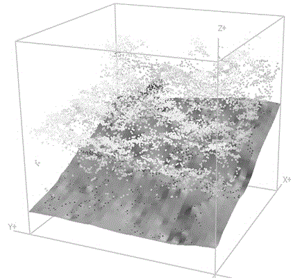
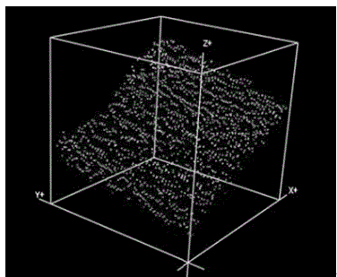
[0046] 1) Use the airborne small-spot full-waveform LiDAR sensor (such as Riegl LMS-Q680i in Austria) for data acquisition. The commonly used remote sensing platforms are: Yun-5 / 12 and other aircraft. The sensor records the complete waveform information returned by each laser pulse, and the sampling interval is 1ns.

[0047] 2) LiDAR waveform data preprocessing

[0048] a) Estimation of noise level, data smoothing and calculation of inflection point: first convert the original data to the frequency domain, and then use the low value part with higher frequency as the judgment standard of noise level. Then use the Gaussian filter for smoothing, because the Gaussian filter can effectively smooth the data while maintaining the trend of the original curve to the greatest extent; judge the pulse intensity of the nearest 4 points around a certain point...

Embodiment 2

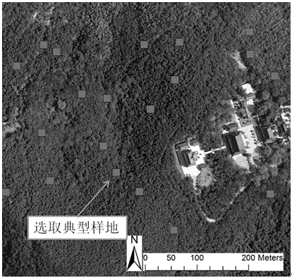
[0069] According to the method of embodiment 1, the classification of tree species in a forest area aimed at a northern subtropical natural secondary mixed forest as the main forest type is illustrated as an example. The forest area is 20-261m above sea level and covers an area of ​​about 1000 hectares. The main tree species are the needle-leaved masson pine (Pinus massoniana) and fir (Cunninghamia lanceolata), and the broad-leaved oak (Quercus acutissima) and sweetgum (Liquidambar formosana). In the forest area, 20 square plots (30×30m) were arranged according to the composition of tree species, forest age and site conditions ( figure 1 ), each tree species was manually identified in each sample plot, and forest parameters such as diameter at breast height, tree height and crown width were measured; the center of the sample plot was positioned by differential GPS, and the relative position of each tree (that is, the horizontal distance from the center of the sample plot) dis...


PUM


Abstract

The invention discloses a tree species classification method based on a LiDAR (Light Detection and Ranging) false-vertical waveform model. The method comprises a step 1 of collecting data using an airborne small-light spot full-waveform LiDAR sensor, in order to obtain complete waveform information, wherein the sampling interval is 1ns; a step 2 of preprocessing LiDAR waveform data; a step 3 of establishing a false vertical wave through waveform structural decomposition and comprehensive waveform recombination; a step 4 of carrying out single tree segmentation and information integration; a step 5 of gathering point cloud attributes within in a single tree range and calculating a comprehensive waveform characteristic parameter; and a step 6 of carrying tree species classification with a support vector machine classifier. With the tree species classification method, acquired LiDAR energy signals can be enhanced; on the basis of single tree segmentation, comprehensive waveform characteristic variables are extracted from multiple dimensions, and thus classification accuracy of tree species in the subtropical forest is obtained and improved by a single data source; spatial and temporal variation of main tree species of a forest type can be well embodied; through experimental verification results, the method provided by the invention is improved by 10% in terms of overall precision compared with other LiDAR-employing tree species classification methods; and the Kappa coefficient is improved by 0.1.

Description

technical field [0001] The invention belongs to the technical field of tree species classification methods, in particular to a tree species classification method based on a LiDAR pseudo-vertical waveform model. Background technique [0002] How to quickly, quantitatively and accurately automate the extraction and identification of the main tree species in the forest is one of the difficulties in forestry remote sensing research. It has important practical significance in the management of forest resources. Conventional forest type or tree species survey methods mainly rely on a combination of field surveys and large-scale aerial photo interpretation, and their accuracy is often not high. At the same time, due to the influence of the phenomenon of "same object with different spectrum" and "same spectrum with different object", the traditional optical remote sensing method is often not effective in identifying forest types or tree species groups, and it is difficult to apply ...

Claims


Application Information

Patent Timeline
IPC IPC(8): G01S7/48G01S17/88
CPCG01S7/4802G01S17/88
Inventor 曹林许子乾代劲松汪贵斌
Owner NANJING FORESTRY UNIV
Why Eureka
Try Eureka