
Mobile platform outdoor positioning method based on multi-sensor fusion

A multi-sensor fusion, mobile platform technology, applied in satellite radio beacon positioning systems, instruments, measuring devices, etc. Accurate positioning requirements and other issues, to achieve the effect of easy promotion, high positioning accuracy and low cost

Inactive Publication Date: 2015-11-11
XI AN JIAOTONG UNIV
View PDF4 Cites 14 Cited by
  • Summary
  • Abstract
  • Description
  • Claims
  • Application Information

AI Technical Summary

Problems solved by technology

However, the environmental layout of the former is relatively complicated, and the most important thing is that infrared sensing and ultrasonic detection are easily interfered by the complex outdoor environment, and it is difficult to meet the high-precision positioning requirements; the latter mainly uses the strength of electromagnetic signals to calculate the relationship between nodes on the mobile platform and other The distance between the reference nodes is used to calculate the position of the mobile platform based on the geometric relationship. It is very difficult to arrange the reference nodes outdoors, the cost is high, and it is easily interfered by other electromagnetic signals, and the accuracy is low
[0004] Zhejiang University proposed a multi-target outdoor positioning system and positioning method based on video acquisition. Although it has a certain positioning accuracy, the positioning system can only locate the living body with a pulse, and cannot meet the high-precision positioning requirements of the mobile platform.
Harbin Institute of Technology proposed a WiFi outdoor positioning method to establish / update the micro-assisted signal coverage map. Compared with the traditional WiFi outdoor positioning method, although the speed of WiFi outdoor positioning has been improved, in view of some inherent defects of WiFi positioning mentioned above , so that this method can only be applied to occasions where the outdoor environment is relatively simple and the requirements for positioning accuracy are not very high.

Method used


Image

  • Mobile platform outdoor positioning method based on multi-sensor fusion
  • Mobile platform outdoor positioning method based on multi-sensor fusion

Examples


Embodiment 1

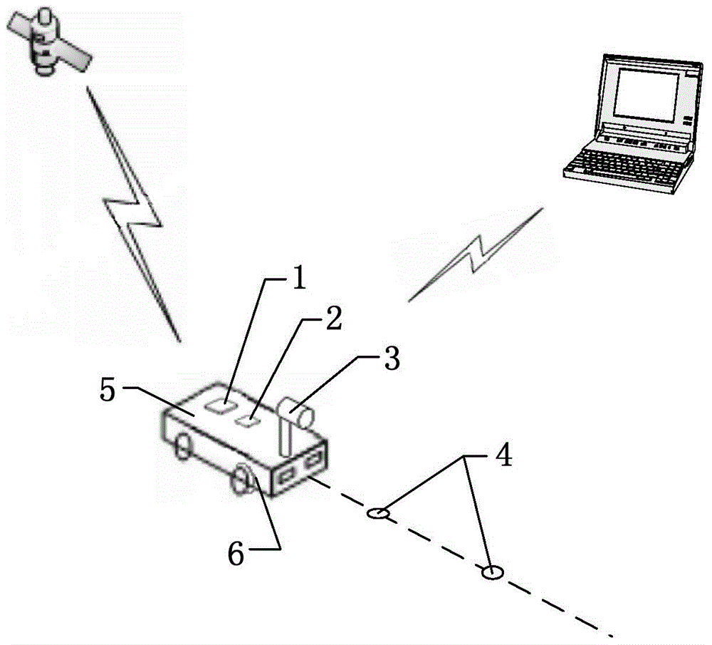
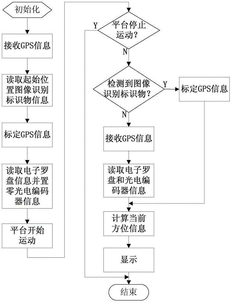
[0034] Embodiment 1: The following takes the outdoor intelligent inspection robot of a digital community as an example to specifically illustrate the outdoor high-precision positioning method of a mobile platform based on multi-sensor fusion in the present invention. The intelligent inspection robot is mainly a robot that replaces the security guard and automatically completes the security inspection in the digital intelligent community. In this embodiment, the positioning system uses the power source carried by the inspection robot itself to switch power to each module through the power module. The outdoor high-precision positioning of mobile platforms based on multi-sensor fusion can be achieved through the following five steps:

[0035] (1) Arrangement of image recognition markers: evenly place markers on the inspection path of the intelligent inspection robot (the corners can be properly placed densely according to the situation), and store the position information of the ...


PUM


Abstract

The invention discloses a mobile platform outdoor positioning method based on multi-sensor fusion, and realizes high-precision position and direction measurement of a mobile platform. The positioning method is suitable for any occasion outdoors where an image identification marker can be placed on the ground and the mobile platform can freely moves. A system includes a power module, a controller module, a display module, a GPS wide-range positioning module, a partial high-precision positioning module formed by a camera and an inertia positioning module comprising an electronic compass and a photoelectric encoder. The method includes five steps, i.e., arrangement of the image identification marker, GPS information acquisition, image identification marker information acquisition through collection by the camera, electronic compass and photoelectric encoder information acquisition, and position and direction calculation and display. A multi-sensor fusion outdoor positioning technology provided by the invention can obtain global and partial position and direction information, and is low in cost, high in precision, good in real-time performance, wide in range of application and strong in expandability.

Description

technical field [0001] The invention relates to the field of outdoor positioning of mobile platforms, in particular to an outdoor high-precision positioning method for mobile platforms based on multi-sensor fusion. Background technique [0002] With the development of electronic technology, control technology, sensor measurement technology, signal processing technology, and computer technology, positioning technology has also achieved rapid development and has been widely used. [0003] At present, the indoor and outdoor direction information is mainly obtained through the electronic compass, and has relatively high accuracy; the indoor position information is mainly obtained from the local position information, and the existing technology is quite mature; the outdoor position information acquisition is currently the most widely used GPS positioning and navigation system, although the technology is relatively mature, but the accuracy of civilian use is not ideal, it is diffi...

Claims


Application Information

Patent Timeline
Patent Type & Authority Applications(China)
IPC IPC(8): G01S19/45G01S19/47G01C21/16G01C11/00
CPCG01S19/45G01C11/00G01C21/165G01S19/47
Inventor 王孙安程元皓霍帅于德弘张斌权
Owner XI AN JIAOTONG UNIV
Features
  • Generate Ideas
  • Intellectual Property
  • Life Sciences
  • Materials
  • Tech Scout
  • Unparalleled Data Quality
  • Higher Quality Content
  • 60% Fewer Hallucinations
Learn More