Parallel mode grid image slicing method

An image and raster technology, applied in the field of raster image slicing in parallel mode, can solve problems such as time-consuming, limited degree of parallelism, and limited parallel capacity

Active Publication Date: 2016-05-04
NAT UNIV OF DEFENSE TECH
View PDF2 Cites 13 Cited by
  • Summary
  • Abstract
  • Description
  • Claims
  • Application Information

AI Technical Summary

Problems solved by technology

[0004] At present, there are three main ideas for raster image parallel slicing methods: one is CPU (Central Processing Unit, central processing unit) + GPU (Graphic Processing Unit, graphics processing unit), which utilizes the computing power of GPU for parallel acceleration. Limited to the capabilities of GPU hardware, the degree of parallelism is limited, and it will increase the cost of the system architecture; the other is to use a distributed cluster system to divide the slicing task into multiple subtasks, and each subtask is performed on multiple distributed nodes simultaneously. This method can be more convenient to parallelize the original serial method, but when the data scale is relatively large, the distributed storage of data in the early stage and the merging of results in the later stage are time-consuming; the other is based on multi-threaded parallel technology , each thread di

Method used


Image

  • Parallel mode grid image slicing method
  • Parallel mode grid image slicing method
  • Parallel mode grid image slicing method

Examples


Embodiment Construction

[0040] In order to make the principles, implementation steps, and advantages of the present invention clearer, the present invention will be further described below in conjunction with the accompanying drawings and related examples.

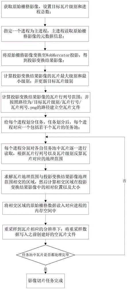
[0041] figure 1 It is a schematic diagram of the overall flow of the present invention. First, set the main process, the target tile level level, the total number of processes n, and the tile output root directory, and then the main process reads metadata information such as the original grid image projection coordinates, length and width, and the main process Use the GDALAutoCreateWarpedVRT function of the GDAL (GeospatialDataAbstractionLibrary, geospatial data abstraction library) class library to project the original raster image into the WebMercator projection coordinate system. The projection transformation result image is saved in a vrt format file, and all subsequent slicing operations are based on the projection The transformation result ...


PUM


Abstract

The present invention belongs to the field of the geographic space information processing technology, and relates to a parallel mode grid image slicing method. The method provided by the invention comprises the following steps: the step 1: obtaining an original grid image, and setting a target tile grade and the total number of processes; the step 2: reading meta-data information of the original grid image; the step 3: converting the original grid image to WebMercator projection; the step 4: calculating the max grade and the mix grade of the tiles of the projection conversion result image; the step 5: calculating the range of the tile rank numbers of the projection conversion result image, and establishing an empty tile file; and the step 6: dividing tasks for each process through adoption of a wheel method; the step 7: reading tiles in each task pool one by one through each process, inversely calculating the geographical range with respect to the tiles, calculating the relative position and the size of an intersecting region in the projection conversion result image, and reading the original grid data of the intersecting region into a memory space; and the step 8: writing resampling data in built empty tile file after resampling the original grid data of the intersecting region.

Description

technical field [0001] The invention belongs to the technical field of geospatial information processing, and relates to a raster image slicing method in parallel mode. technical background [0002] With the rapid development of satellite sensor technology and UAV aerial photography technology, the spatial and temporal resolution of remote sensing images has been greatly improved, and the data volume of a single remote sensing image file has also increased dramatically. The current mainstream GIS software and Internet map applications widely use the release strategy of map slices (Tile, also known as tiles) in WebGIS (Network Geographic Information System) solutions. Cut into tiles of the same size, and load small data tiles to achieve efficient image display under the condition of limited network bandwidth. However, the current commercial GIS software has a high cost of generating and publishing map slices, and the operation is more complicated. Taking the well-known ArcGI...

Claims


Application Information

Patent Timeline
IPC IPC(8): G06T1/20G06T7/00G06F17/30
CPCG06F16/957G06T1/20G06T2207/20021
Inventor 刘世永李军吴秋云熊伟陈荦钟志农吴烨
Owner NAT UNIV OF DEFENSE TECH
Why Eureka
Try Eureka