Optical remote sensing satellite point target observation task dynamic imaging posture modeling method

A technology of optical remote sensing and satellite points, applied in photogrammetry/video metrology, measuring devices, surveying and mapping and navigation, etc., can solve problems such as difficult to achieve effective combination of mission planning and satellite attitude control, no description conversion, no involvement, etc.

Active Publication Date: 2017-05-31
SPACE STAR TECH CO LTD
View PDF8 Cites 22 Cited by
  • Summary
  • Abstract
  • Description
  • Claims
  • Application Information

AI Technical Summary

Problems solved by technology

[0010] (1) Patent "A Method for Realizing an Agile Satellite On-Orbit Mobile Imaging Task", ZL201210253812.8, Aerospace Dongfanghong Satellite Co., Ltd., proposed a satellite mobile imaging command annotation and on-board computer control method, which can be used in motion Attitude control of imaging satellites, but this result has no basis for how to convert observation task requirements into satellite control instructions and on-board computer control;
[0011] (2) Patent "A attitude adjustment method for dynamic imaging of agile satellites", ZL201310028956.8, Aerospace Dongfanghong Satellite Co., Ltd., proposed a large-width imaging method in the process of attitude adjustment using agile satellite dynamic imaging , but this result is not suitable for point target observation task planning and attitude control;
[0012] (3) Patent application "A New Imaging Method for Agile Satellite Maneuvering", 201410163903.1, Aerospace Dongfanghong Satellite Co., Ltd., proposed a method for calculating the attitude angle of agile satellite maneuvering imaging process based on the geographic location of known ground feature imaging feature points , but it does not explain how to obtain the geographic location of feature points in ground object imaging, nor does it explain the relationship between the requirements of the observation task and the determination of the location of feature points in ground feature imaging;
[0013] (4) Patent application "A Trajectory Planning Method for Attitude Maneuvering", 201410515853.9, Bei

Method used


Image

  • Optical remote sensing satellite point target observation task dynamic imaging posture modeling method
  • Optical remote sensing satellite point target observation task dynamic imaging posture modeling method
  • Optical remote sensing satellite point target observation task dynamic imaging posture modeling method

Examples


Embodiment 1

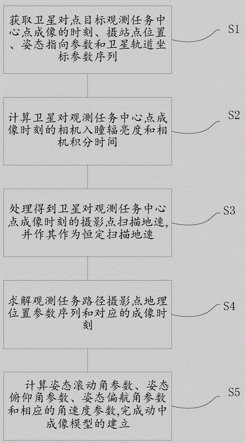
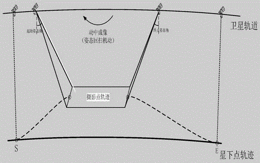
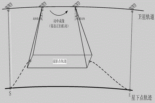
[0044] figure 1 It is the overall flowchart of the present invention; figure 2 Schematic diagram of the attitude active retrace point target imaging mode for imaging in motion; image 3 Schematic diagram of the attitude active forward scanning point target imaging mode for imaging in motion. refer to figure 1 , figure 2 and image 3 As can be seen, the present invention discloses a method for modeling the imaging attitude in motion of an optical remote sensing satellite point target observation task, comprising steps:

[0045] S1: Obtain the time when the center point of the satellite's point target observation task is imaged, the position of the shooting site, the attitude pointing parameter and the satellite orbit coordinate parameter sequence;

[0046] S2: Calculate the camera entrance pupil radiance and camera integration time at the moment when the satellite images the center point of the observation task;

[0047] S3: Based on the integration time of the camera, ...

Embodiment 2

[0133] Figure 4 is a schematic diagram of the imaging attitude model in motion in the present invention, and the parameters Figure 4 It can be seen that the present invention also provides an imaging attitude model in motion using any disclosed optical remote sensing satellite point target observation task imaging attitude modeling method in the present invention, including:

[0134] The basic parameter acquisition module 1 is used to obtain the time when the center point of the satellite's point target observation task is imaged, the position of the camera site, the attitude pointing parameter and the satellite orbit coordinate parameter sequence;

[0135] Camera-related parameter calculation module 2, used to calculate the camera entrance pupil radiance and camera integration time at the moment when the satellite images the center point of the observation task;

[0136] The scanning ground speed module 3 is used to process the associated parameters based on the camera int...


PUM


Abstract

The invention discloses an optical remote sensing satellite point target observation task dynamic imaging posture modeling method, which comprises the steps of obtaining the point target observation task center point imagining time of a satellite, camera station point position, posture pointing parameters and satellite orbit coordinate parameter sequences; calculating the camera pupil entrance radiant brightness and the camera integral time of the satellite on the observation task center point imagining time; on the basis of the camera integral time, processing the relevant parameters to obtain the camera station point scanning ground velocity of the satellite on the observation task center point imagining time, and using the scanning ground velocity as the constant scanning ground velocity; on the basis of the constant scanning ground velocity, solving the observation task path camera station point geographic position parameter sequence and the corresponding imaging time; calculating the posture rolling angle parameter, the posture pitch angle parameter, the posture yaw angle parameter and the corresponding angular speed parameter of each imaging time of the observation task, and completing the dynamic imaging posture model building on the basis. The effective combination of task planning and satellite posture control can be realized to a certain degree.

Description

technical field [0001] The invention belongs to the field of satellite imaging task analysis and attitude control, in particular to an imaging attitude modeling method in motion for an optical remote sensing satellite point target observation task. Background technique [0002] High-agility attitude maneuvering capability is one of the important development directions of optical remote sensing satellites. Traditional agile optical remote-sensing satellites (hereinafter referred to as agile satellites) use agile attitude maneuvers to quickly adjust the attitude pointing before imaging to point the optical axis of the satellite camera to the observation target. After imaging, agile attitude maneuvers are also used to quickly reset the attitude or point to the next observation target. However, during the imaging process, traditional agile satellites do not perform attitude maneuvers, but still use traditional passive push-broom imaging. [0003] Optical remote sensing satellite...

Claims


Application Information

Patent Timeline
IPC IPC(8): G01C11/00
CPCG01C11/00
Inventor 张晓田志新赵卫王剑曹京乔亦实韩倩严冬贺誉肖倩李婷李贞
Owner SPACE STAR TECH CO LTD
Why Eureka
Try Eureka