High-voltage cable electromagnetic-fingerprint distribution based unmanned-aerial-vehicle navigation system and method

A navigation system and unmanned aerial vehicle technology, applied in the field of unmanned aerial vehicle navigation system based on the distribution of electromagnetic fingerprints of high-voltage lines, can solve problems such as satellite navigation system errors, achieve the effects of improving efficiency, stabilizing electromagnetic field strength, and reducing the amount of calculation

Inactive Publication Date: 2018-01-19
SHANGHAI UNIV OF ENG SCI
View PDF10 Cites 18 Cited by
  • Summary
  • Abstract
  • Description
  • Claims
  • Application Information

AI Technical Summary

Problems solved by technology

Its positioning method mainly adopts the time-ranging navigation positioning method, that is, the user receives the propagation time of the signal sent by 4 satellites that are not on the same plane (in order to ensure the uniqueness of the result, the 4 satellites cannot be on the same plane), and then complet

Method used


Image

  • High-voltage cable electromagnetic-fingerprint distribution based unmanned-aerial-vehicle navigation system and method
  • High-voltage cable electromagnetic-fingerprint distribution based unmanned-aerial-vehicle navigation system and method

Examples


Embodiment

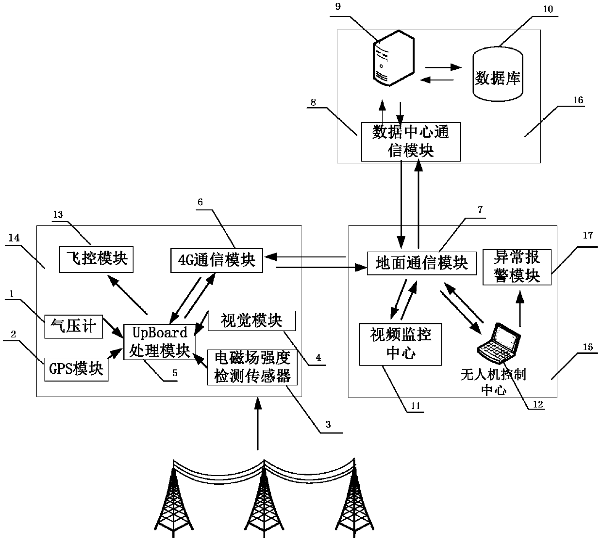
[0035] Electromagnetic positioning is a positioning method that uses the spatial distribution information of electromagnetic fields to obtain the position and attitude of the target. It has the characteristics of no shooting damage, no line of sight obstacles, and simple and convenient operation. According to Maxwell's electromagnetic field theory, there is a certain intensity of electromagnetic field around the high-voltage transmission line, and the electric field and magnetic field around the transmission line are distributed according to certain laws and have certain stability. The electromagnetic field detection sensor on the UAV can detect the strength and direction of the electromagnetic field at the current location, and the altitude information and latitude and longitude coordinate information of the current location can be detected by the GPS module and the barometer on the UAV. Through regular collection The electromagnetic field information of different points in th...


PUM


Abstract

The invention relates to a high-voltage cable electromagnetic-fingerprint distribution based unmanned-aerial-vehicle navigation system which comprises an unmanned-aerial-vehicle flight subsystem (14),a data processing subsystem (16) and a ground control subsystem (15). The unmanned-aerial-vehicle flight subsystem (14) transmits high-voltage cable electromagnetic field strength data to the data processing subsystem (16), the data processing subsystem (16) has data matched in a fingerprint database to acquire unmanned-aerial-vehicle real-time position coordinates, and the ground control subsystem (15) navigates an unmanned aerial vehicle according to the real-time position coordinates, wherein the fingerprint database contains corresponding information of high-voltage cable electromagneticfield strength and the position coordinates. Compared with the prior art, the high-voltage cable electromagnetic-fingerprint distribution based unmanned-aerial-vehicle navigation system has the advantages that the unmanned aerial vehicle is positioned and navigated by the aid of the electromagnetic field strength fingerprint information around a high-voltage cable, which is complementary to a traditional satellite navigation mode, and position stability of the unmanned aerial vehicle under high-voltage inspection environment is improved.

Description

technical field [0001] The present invention relates to a drone navigation system, in particular to a drone navigation system and method based on high-voltage line electromagnetic fingerprint distribution. Background technique [0002] At present, the total length of my country's transmission lines exceeds 1.15 million kilometers, ranking first in the world in scale, but my country's power line inspection methods and technologies are still lagging behind. Traditional power inspections mainly rely on manual inspections and manual input into computers, which is inefficient. For example, when performing a 100km power line inspection task, 20 inspectors need to work continuously for one day to complete it, not including encounters. to complex terrain such as mountains and rivers. When it is necessary to climb to the high-voltage line for inspection in sudden and emergency situations, in order to ensure the personal safety of the inspectors, the line power failure inspection wil...

Claims


Application Information

Patent Timeline
IPC IPC(8): G05D1/10G05D1/08
Inventor 毛万葵吴飞钟亚洲曹琨章裕润骆立志陈珊珊陈计伟
Owner SHANGHAI UNIV OF ENG SCI
Why Eureka
Try Eureka