A method for automatic extraction of forest canopy closure by UAV digital elevation model

A technology of digital elevation model and forest canopy density, applied in 3D modeling, image data processing, image enhancement, etc., can solve problems such as low efficiency and poor precision, and achieve wide application, improved precision and accuracy, and application prospects broad effect

Active Publication Date: 2019-03-15
NANJING FORESTRY UNIV
View PDF2 Cites 0 Cited by
  • Summary
  • Abstract
  • Description
  • Claims
  • Application Information

AI Technical Summary

Problems solved by technology

[0003] The traditional methods for extracting canopy density of forest resources include visual inspection, canopy projection, line transect, sample point, and photograph. Since the development of remote sensing technology, researchers have tried to obtain the value of forest canopy density through remote sensing image data. At present, most of the image data based on this research are DOM (Digital Orthophoto) and DSM (Digital Surface Model), which requires professionals to assist a large number of in-house processing operations to complete, and at the same time, the accuracy is poor and the efficiency is low.

Method used


Image

  • A method for automatic extraction of forest canopy closure by UAV digital elevation model
  • A method for automatic extraction of forest canopy closure by UAV digital elevation model
  • A method for automatic extraction of forest canopy closure by UAV digital elevation model

Examples


Embodiment 1

[0028] A method for automatically extracting forest canopy density through a UAV digital elevation model, the steps are as follows:

[0029] 1) Taking Dongtai Forest Farm in Jiangsu Province as an object, obtain the remote sensing image data set of the implementation area (September 15, 2017) through UAV remote sensing equipment (such as DJI multi-rotor UAV), and use the flight control system (such as : Pix4DCapture) for route setting: flight altitude 120m, flight speed 1.6m / s, camera angle 90°, course / side overlap 90%,;

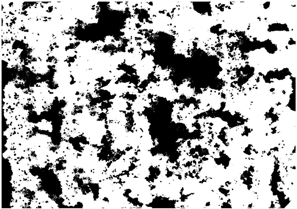
[0030] 2) Filter and process the acquired remote sensing image data sets, eliminate data with low imaging quality and poor exposure effect in the image data, and use data modeling software (for example: Agisoft Photoscan) to carry out image mosaic modeling, including: pictures Optimize alignment, space fitting, dense point cloud generation, grid generation and other operation processes, and finally generate DEM data, such as figure 1 shown. Due to the occl...


PUM


Abstract

The invention discloses a method for automatically extracting forest canopy density through an unmanned aerial vehicle digital elevation model, and takes Dongtai Forest Farm of Jiangsu Province as the implementation object of the method. Firstly, the image data of Dongtai Forest Farm was acquired by UAV, and the image data was spliced ​​through digital modeling to extract the DEM data; then, the remote sensing image processing software was used to extract the pixel value interval of the non-canopy area in the target DEM data, And carry out mask processing, and finally obtain the proportion of the masked section and the non-masked section through statistical analysis, so as to obtain the accurate value of the forest canopy density. Compared with other canopy closure measurement algorithms, the accuracy and precision of this method have been greatly improved, especially the work efficiency has been greatly improved.

Description

technical field [0001] The invention belongs to the technical fields of forestry investigation, resource dynamic monitoring, biodiversity and the like, and relates to a method for automatically extracting forest canopy density through an unmanned aerial vehicle digital elevation model (UAV-DEM). Background technique [0002] Forest is an important material resource for the survival and development of human beings, and it plays a vital role in the balance of terrestrial ecosystems. Forest resource survey is an important task in the process of forest management and development. Implementing forest resource survey work can effectively understand Growth and decline of forest resources. In forest resources investigation, canopy density is a very important index parameter, which is of great significance to the assessment of the current situation of forest resources. [0003] The traditional methods for extracting canopy density of forest resources include visual inspection, canop...

Claims


Application Information

Patent Timeline
Patent Type & Authority Patents(China)
IPC IPC(8): G06T17/05G06T5/50G06T3/40
CPCG06T3/4038G06T5/50G06T17/05G06T2207/10028G06T2207/10032G06T2207/30188
Inventor 徐雁南马骏代婷婷
Owner NANJING FORESTRY UNIV
Why Eureka
Try Eureka