Satellite image system error correction method based on RPC model

A system error and satellite image technology, applied in the field of remote sensing image processing, can solve problems such as poor timeliness, high cost, and low frequency, and achieve simple, high timeliness, and low cost effects

Active Publication Date: 2019-03-22
CHINA CENT FOR RESOURCES SATELLITE DATA & APPL
View PDF6 Cites 5 Cited by
  • Summary
  • Abstract
  • Description
  • Claims
  • Application Information

AI Technical Summary

Problems solved by technology

In the processing of satellite images, the on-orbit geometric calibration method is usually used to correct them. However, due to the drift of the satellite system error parameters, the geometric accuracy of satellite images will decrease within a period of time.
However, due to the limited number of geometric calibration fields available in my country, and the timeliness of obtaining cloud-fr...

Method used


Image

  • Satellite image system error correction method based on RPC model
  • Satellite image system error correction method based on RPC model
  • Satellite image system error correction method based on RPC model

Examples


Embodiment

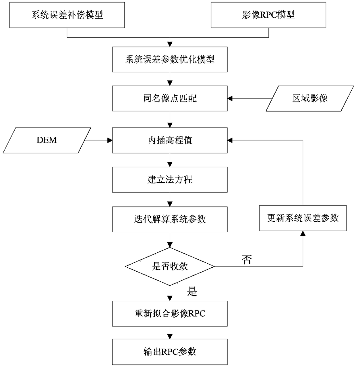
[0052] The specific implementation of the present invention will be described in detail below in conjunction with the accompanying drawings and examples. see figure 1 , the process of the embodiment can be divided into four steps, and the specific method, formula and process implemented in each step are as follows:

[0053] 1. For the load that needs to correct the systematic error, select images that cover the same area within a certain time range (within one month) and have a certain overlap in the direction of the vertical track (the overlap is about 50%);

[0054] 2. Automatic matching of points with the same name and measurement of control points. For overlapping images, a matching algorithm based on the SIFT operator is used to densely match a certain number of points with the same name in a narrow area in the direction of the vertical rail, and a certain number of control points are measured in the survey area. Measure the position of the control point.
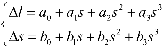
[0055] 3. S...


PUM


Abstract

The invention discloses a satellite image system error correction method based on a RPC model. An improvement model of system errors is pushed to a generalized rational polynomial model from a rigorous geometric imaging model, and then improvement of the image system errors is pushed to a satellite image product stage from pre-processing resolving. According to the satellite image system error correction method based on the RPC model, by adding a generalized error compensation model to a RPC model image space to build an optimization model of the system errors, and then using mutual constraintconditions between overlapping region images and absolute constraint conditions of control points within a period of time, error parameters are resolved.

Description

technical field [0001] The invention relates to a satellite image system error correction method based on an RPC model, which belongs to the field of remote sensing image processing. Background technique [0002] The correction of system error is an important link in the geometric processing of satellite images, and it is an effective means to improve the direct geometric positioning accuracy of images and improve the relative geometric distortion between images. In the processing of satellite images, the on-orbit geometric calibration method is usually used to correct them. However, due to the drift of the systematic error parameters of satellites, the geometric accuracy of satellite images will decrease within a period of time. However, due to the limited number of geometric calibration fields available in my country, and the timeliness of obtaining cloud-free images in the calibration field area is very low, the frequency of actual on-orbit calibration of satellites is us...

Claims


Application Information

Patent Timeline
IPC IPC(8): G01C11/04
CPCG01C11/04
Inventor 王冰冰龙小祥李庆鹏崔林喻文勇徐生豪
Owner CHINA CENT FOR RESOURCES SATELLITE DATA & APPL
Why Eureka
Try Eureka