Near-surface air temperature estimation method under cloud conditions
A near-ground and conditional technology, applied in the field of atmospheric remote sensing, can solve the problems of low spatial resolution of microwave channels, weak microwave wavelength radiation signals, and difficult to optimize the estimation accuracy, and achieve the effect of high estimation accuracy and simple and easy method
- Summary
- Abstract
- Description
- Claims
- Application Information
AI Technical Summary
Problems solved by technology
Method used
Image
Examples
Embodiment 1
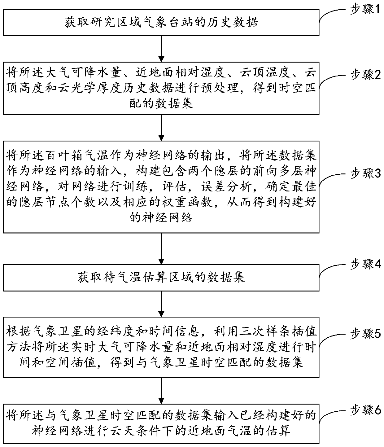
[0033] (1) Obtain the historical data of meteorological stations in the study area;
[0034] The historical data include: air temperature in the shutter box, atmospheric precipitable water, relative humidity near the ground, and cloud top temperature, cloud top height and cloud optical thickness measured under cloudy conditions;
[0035] Specifically, the shutter temperature of the meteorological stations in the study area, the historical data of atmospheric precipitable water and near-surface relative humidity based on the Global Forecast System (GFS), and the corresponding meteorological satellite data of the area were obtained. The meteorological satellite data are included in the available Detected under cloud conditions: cloud top temperature, cloud top height and cloud optical thickness;
[0036] (2) preprocessing the historical data of atmospheric precipitable water, near-surface relative humidity, cloud top temperature, cloud top height and cloud optical thickness, to ...
Embodiment 2
[0046] On the basis of Embodiment 1, this embodiment also adds observation pixel latitude and longitude, elevation, and Julian day as input factors of the neural network, thereby improving the accuracy of surface air temperature estimation in this application. The method is as follows:
[0047] (1) Obtain the shutter temperature of the meteorological stations in the study area, the historical data of atmospheric precipitable water and near-surface relative humidity based on the Global Forecast System (GFS), and obtain the corresponding meteorological satellite data in the area. The meteorological satellite data are included in the available Measured under cloud conditions: cloud top temperature, cloud top height and cloud optical thickness;
[0048] (2) According to the latitude and longitude and time information of meteorological stations, use the cubic spline interpolation method to carry out time and space interpolation processing to the cloud top temperature, cloud top hei...
PUM
 Abstract
Description
Claims
Application Information
 - R&D
- Intellectual Property
- Life Sciences
- Materials
- Tech Scout
- Unparalleled Data Quality
- Higher Quality Content
- 60% Fewer Hallucinations
Browse by: Latest US Patents, China's latest patents, Technical Efficacy Thesaurus, Application Domain, Technology Topic, Popular Technical Reports.
© 2025 PatSnap. All rights reserved.Legal|Privacy policy|Modern Slavery Act Transparency Statement|Sitemap|About US| Contact US: help@patsnap.com


