
A new self-calibrating integrated UAV-borne hyperspectral remote sensing system

A hyperspectral remote sensing and self-calibration technology, applied in the field of hyperspectral optical remote sensing detection, can solve problems such as image deformation, low data acquisition efficiency, low system energy utilization efficiency, and poor stability of UAV platforms, and achieve high miniaturization and light weight. Quantitative requirements, reduced hyperspectral observation costs, and excellent information acquisition capabilities

Active Publication Date: 2020-12-25
OCEAN UNIV OF CHINA
View PDF4 Cites 0 Cited by
  • Summary
  • Abstract
  • Description
  • Claims
  • Application Information

AI Technical Summary

Problems solved by technology

However, the number of effective pixels in the width direction is 696, and the field of view is less than 30°. Due to the need for hovering and sweeping, the operating efficiency is relatively low
And the volume, weight are large, and the cost is high
[0003] To sum up, the problems existing in the existing technology are: due to the limited carrying capacity of the existing widely used small UAV platforms, the field of view of the spectrometer is small, and the load system has higher requirements for miniaturization and light weight. Poor acquisition ability and low time resolution cannot meet the urgent application requirements of large field of view spectrometers
In addition, due to the high requirements for spectral resolution and spatial resolution, the corresponding constraints of data acquisition efficiency and low system energy utilization efficiency are imposed. For the load system, it is urgent to solve the problem of compact structure, large field of view and high system transmission. Comprehensive performance improvement under the technical constraints of three aspects of efficiency
Due to the poor stability of the UAV platform, limited by factors such as cost, size and weight, it is difficult to carry an expensive high-precision POS system (navigation, positioning and orientation system). Image distortion caused by vibration is inevitable
Severe deformation of the image affects the interpretation accuracy, increases the difficulty of interpretation, and greatly limits the application range of the image
It is also the primary problem currently hindering the large-scale development of UAV-borne hyperspectral

Method used


Image

  • A new self-calibrating integrated UAV-borne hyperspectral remote sensing system
  • A new self-calibrating integrated UAV-borne hyperspectral remote sensing system
  • A new self-calibrating integrated UAV-borne hyperspectral remote sensing system

Examples


Embodiment 1

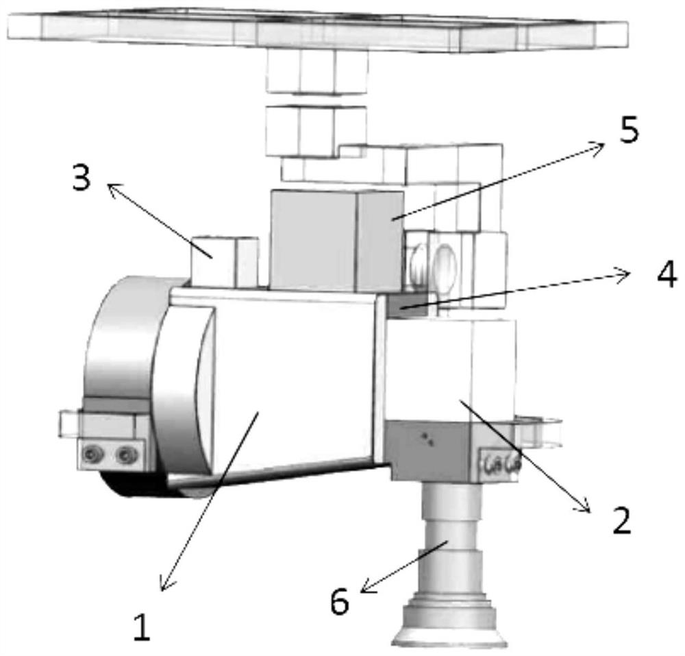
[0038] A new type of self-calibration integrated UAV-borne hyperspectral remote sensing system, including: telecentric telescopic imaging system 6, control and processing module 4, data recording and transmission module 5.

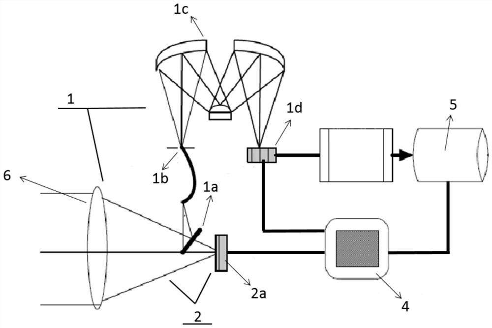
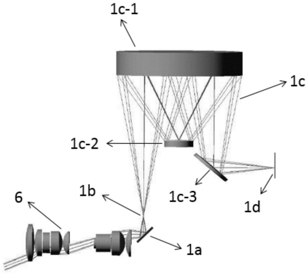
[0039] One side of the telecentric telescopic imaging system 6 is provided with an area array camera 2a, and a knife-edge reflector 1a is obliquely provided between the telecentric telescopic imaging system and the area array camera, such as figure 2 As shown, one side of the knife-edge reflector 1a is provided with an incident slit 1b, a spectral imaging system 1c, and a spectrometer detector 1d; array pushbroom imaging channel 1, as figure 2 , image 3 As shown; the telecentric telescopic imaging system images the ground object radiation in subregions on the focal plane of the area array camera and the incident slit of the spectral imaging system; The images and sub-wavelength images are imaged on the spectrometer detector, and the hyperspectral imag...


PUM


Abstract

The invention relates to a novel self-correcting integrated unmanned aerial vehicle-mounted hyperspectral remote sensing system, and belongs to the technical field of hyperspectral optical remote sensing detection. The system comprises a telecentric telescopic imaging system, a control and processing module and a data recording and transmission module, the telecentric telescopic imaging system, aknife edge reflector, an entrance slit, a spectral imaging system and a spectrometer detector form a linear array push-broom imaging channel. The telecentric telescopic imaging system and the area-array camera form a panchromatic area array channel, the linear array push-broom imaging channel and the panchromatic area array channel share one telecentric telescopic imaging system, and incident light of a scene is divided into two paths through the knife edge reflector. The same optical path and synchronous acquisition of the hyperspectral image and the high-frequency area array image are realized through the compact same optical path integrated load design, the spatial information correction of the hyperspectral image is realized, and the practicability is high.

Description

technical field [0001] The invention relates to a novel self-calibrating integrated UAV-borne hyperspectral remote sensing system, which belongs to the technical field of hyperspectral optical remote sensing detection. Background technique [0002] In recent years, UAV technology has developed rapidly, and various small UAV remote sensing systems have emerged in an endless stream. The high maneuverability and flexibility of the UAV platform make it have great development prospects in the field of remote sensing, effectively making up for the application needs of space-time multi-scale remote sensing, and expanding the application range of more small-scale feature remote sensing. It provides unprecedented development opportunities for the research and development, application and promotion of new technologies in the field of remote sensing. Hyperspectral remote sensing technology is also equipped with the express car of UAV. At present, it has also formed a spectrum imaging ...

Claims


Application Information

Patent Timeline
Patent Type & Authority Patents(China)
IPC IPC(8): G01J3/28G01J3/02G01J3/06
CPCG01J3/0205G01J3/06G01J3/2823
Inventor 薛庆生孙茜王福鹏杨柏田中天栾晓宁牟冰康颖
Owner OCEAN UNIV OF CHINA
Learn More