Autonomous positioning method of outdoor unmanned aerial vehicle

An autonomous positioning and drone technology, applied in the field of unmanned aerial vehicles, can solve problems such as loss of control, positioning failure, and falling of drones

Pending Publication Date: 2020-04-28
HARBIN UNIV OF SCI & TECH
View PDF7 Cites 6 Cited by
  • Summary
  • Abstract
  • Description
  • Claims
  • Application Information

AI Technical Summary

Problems solved by technology

[0002] With the rapid development of technologies such as artificial intelligence and pattern recognition, UAVs have gradually expanded their application fields and research scope, such as post-disaster search and rescue, aerial photography, crop monitoring, and military operations. The positioning technology of mobile robots can be divided into two categories: Category: Absolute positioning technology and relative positioning technology: The implementation of absolute positioning technology is mainly the Global Positioning System (Global Position System, GPS), etc. GPS positioning has many advantages such as: the positioning method is relatively mature and easy to integrate, and the outdoor signal is better In the case of high positioning accuracy, but it has one of the most important disadvantages: relying on external signals, positioning will fail when the GPS signal is blocked, interfered or missing, and the drone will lose control or even fall; while the relative positioning technology is It uses the sensor carried by the robot itself to calculate the initial position of the robot and the position and motion state at each moment to achieve positioning. unknown, it is necessary to study the autonomous positioning of drones

Method used


Image

  • Autonomous positioning method of outdoor unmanned aerial vehicle
  • Autonomous positioning method of outdoor unmanned aerial vehicle
  • Autonomous positioning method of outdoor unmanned aerial vehicle

Examples


Embodiment Construction

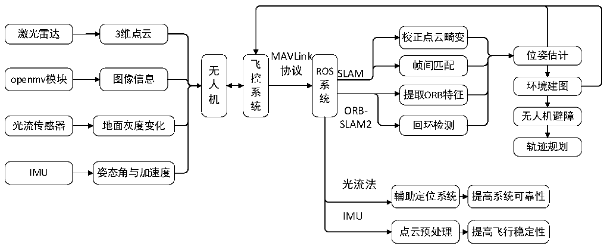
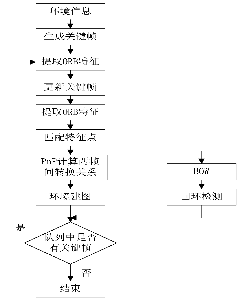
[0015] This embodiment is dedicated to providing a system for autonomous positioning of outdoor UAVs based on fusion of 2D lidar and depth cameras. The fusion of 2D lidar and depth cameras uses laser SLAM algorithms and ORB-SLAM algorithms to convert sensor The position information of the human-machine and the environmental map are analyzed and synthesized for the purpose of correcting point cloud distortion and optimizing the mapping information, so as to complete the decision-making and pose estimation required for the autonomous positioning of the UAV.

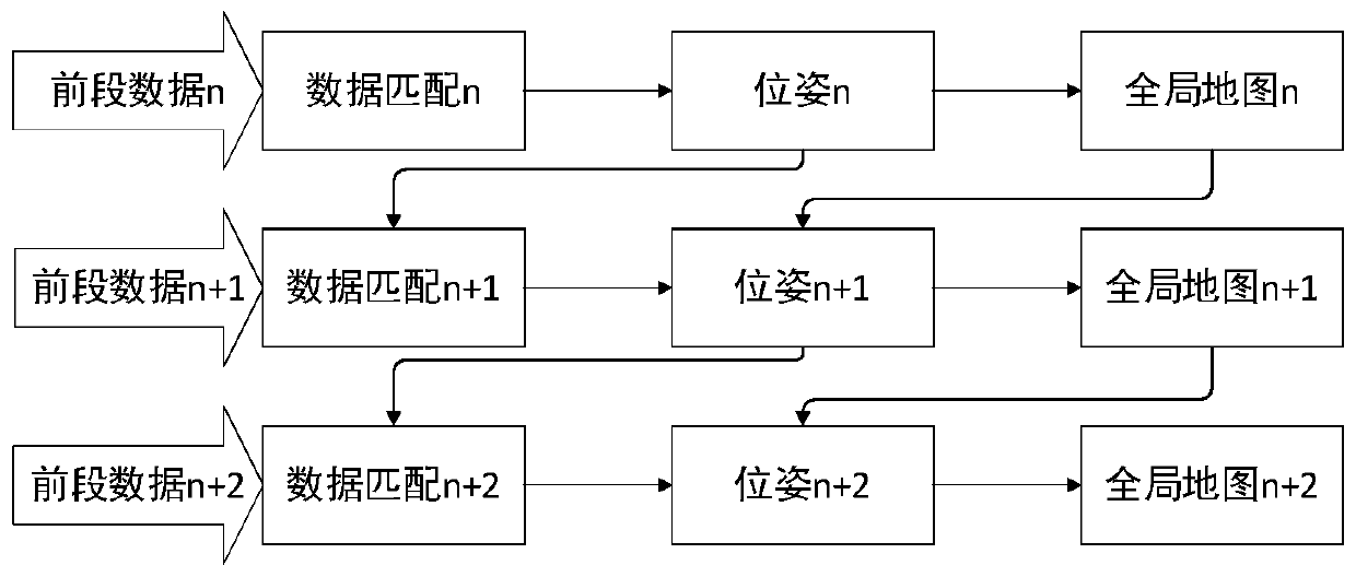
[0016] Through the multi-level data fusion and data optimization processing of the 2D lidar and depth camera point cloud, the precise pose information and dense map information of the drone are finally obtained. In this process, the SLAM algorithm is fully used for data processing. Calculate and obtain separated observation information, save and export useful information.

[0017] figure 1 The structural block diagram of t...


PUM


Abstract

The invention provides an autonomous positioning method of an outdoor unmanned aerial vehicle. The method comprises an unmanned aerial vehicle, a 2D laser radar used for generating environment point cloud information to complete autonomous positioning and mapping, a binocular depth camera used for collecting image information and sparse point cloud information to improve positioning precision andmapping precision, an inertial measurement unit used for measuring and calculating pose information of the unmanned aerial vehicle to improve flight stability, an optical flow sensor used for detecting ground gray information to complete unmanned aerial vehicle auxiliary positioning and improve the system reliability, a flight control system used for controlling the unmanned aerial vehicle to move, and a ground station used for providing a man-machine interaction function. The invention provides the outdoor unmanned aerial vehicle autonomous positioning method which is high in positioning precision, visual in mapping effect, high in system reliability and good in flight performance.

Description

technical field [0001] The present invention relates to the technical field of unmanned aerial vehicles, and more specifically relates to a system and method for precise positioning of outdoor unmanned aerial vehicles based on fusion of 2D laser radar and depth camera. Background technique [0002] With the rapid development of technologies such as artificial intelligence and pattern recognition, UAVs have gradually expanded their application fields and research scope, such as post-disaster search and rescue, aerial photography, crop monitoring, and military operations. The positioning technology of mobile robots can be divided into two categories: Category: Absolute positioning technology and relative positioning technology: The implementation of absolute positioning technology is mainly the Global Positioning System (Global Position System, GPS), etc. GPS positioning has many advantages such as: the positioning method is relatively mature and easy to integrate, and the outd...

Claims


Application Information

Patent Timeline
Patent Type & Authority Applications(China)
IPC IPC(8): G05D1/10
CPCG05D1/101
Inventor 马静邢佳雪徐军
Owner HARBIN UNIV OF SCI & TECH
Why Eureka
Try Eureka