Semantic high-precision map construction and positioning method based on point-line feature fusion laser

A feature fusion and map construction technology, applied in structured data retrieval, geographic information database, electromagnetic wave re-radiation, etc., can solve the problems of high dependence on 3D high-precision maps, mismatching and unsuccessful high-precision maps, etc.

Pending Publication Date: 2020-09-11
DONGFENG AUTOMOBILE COMPANY
View PDF5 Cites 29 Cited by
  • Summary
  • Abstract
  • Description
  • Claims
  • Application Information

AI Technical Summary

Problems solved by technology

Compared with traditional GPS-based positioning, high-precision map-based matching positioning is not affected by GPS signals, and can still operate in tunnels, elevated environments, etc.; however, laser matching-based positioning methods rely heavily on 3D high-precision maps. Therefore, when the scene changes, the high-precision map is prone to mis-matching or unsuccessful matching, and the map needs to be updated continuously, resulting in high operating costs.

Method used


Image

  • Semantic high-precision map construction and positioning method based on point-line feature fusion laser
  • Semantic high-precision map construction and positioning method based on point-line feature fusion laser
  • Semantic high-precision map construction and positioning method based on point-line feature fusion laser

Examples


Embodiment 1

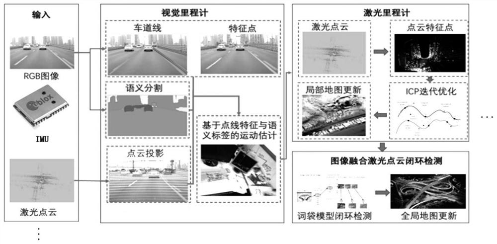
[0072] This embodiment provides a method for constructing a semantic high-precision map.

[0073] like figure 1 As shown, the basic process of this method is: input of image, point cloud, gps, IMU and other data → visual odometry → laser odometry → global map update, where visual odometry includes semantic segmentation, lane line detection, and feature point extraction → Obtain point, line features, semantic information → motion estimation (moving target elimination, pose estimation), laser odometer includes pose optimization (ICP iterative optimization, local map update). In this embodiment, improvements are mainly aimed at moving target elimination, pose estimation and optimization steps. Specifically include:

[0074] 1. Moving target removal

[0075] 1) Use the semantic segmentation network (such as FCN, Segnet, RefineNet, PSPNet, Deeplab v1&v2&v3, etc.) to perform semantic segmentation on the visual images collected by the camera, and use Hough, brief, etc. for feature...

Embodiment 2

[0103] This embodiment is mainly aimed at the positioning of dynamic scenes such as port areas and underground parking lots.

[0104] First, analyze the problems existing in conventional methods in the positioning of port areas and underground parking lots.

[0105] The port has the following characteristics: 1) The gantry crane in the unloading and loading area of ​​the port is mobile, and its position may change at any time, so laser matching and positioning based on a fixed map cannot be applied; 2) The GPS signal under the gantry crane is weak, and the lateral positioning accuracy is difficult to guarantee The accuracy of unloading and loading is required, so GPS positioning cannot be used; 3) The position of the container in the unloading area will change with time, so the traditional visual matching or laser matching cannot be successful, and the map needs to be updated continuously, which improves the operational efficiency Complexity.

[0106] The underground parking ...

Embodiment 3

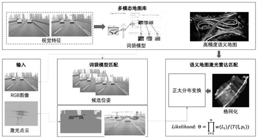
[0123] This embodiment provides a lane lateral positioning method based on the semantic high-precision map library constructed in Embodiment 1 and integrating low-precision GPS for closed scenes such as high speeds.

[0124] This method takes advantage of the characteristics of high efficiency, robustness and strong structure of lane line extraction, and applies it to the lateral positioning of unmanned vehicles on high-speed sections. Its core technical process is as follows: Figure 4 shown.

[0125] This method first extracts the lane line from the input visual image, and performs grayscale binarization processing to obtain the lane line binary image; then performs distance transformation on the binary image to obtain a distance map; at the same time, according to the GPS given The positioning information is obtained from the map library to obtain the vector high-precision lane line map of the current position, and the distance transformation is also performed on the lane l...


PUM


Abstract

The invention discloses a semantic high-precision map construction method based on dot-line feature fusion laser, which comprises the following steps: 1) performing semantic segmentation and feature extraction on a visual image acquired by a camera to obtain a visual image containing semantic categories and dot-line features, and then obtaining a foreground and a background of a moving target; 2)projecting the laser three-dimensional point cloud acquired by the laser radar onto a visual image plane, fitting to obtain a depth map, and endowing the laser three-dimensional point cloud with semantic categories and dot line features; 3) performing super-pixel segmentation on the moving target, calculating the distance between super-pixel blocks, constructing a graph model, performing image segmentation, and accurately extracting the boundary of the moving target; and 4) removing the visual feature points and the laser three-dimensional points belonging to the moving target to construct a static high-precision semantic three-dimensional map. The invention further discloses athe positioning method of the semantic high-precision map constructed by adopting the method, and the mapping is more accurate and reliable by accurately removing the moving target.

Description

technical field [0001] The invention relates to a semantic high-precision map, in particular to a semantic high-precision map construction and positioning method based on point-line feature fusion laser. Background technique [0002] High-precision positioning is the basis for realizing the automatic driving of unmanned vehicles, and provides a basic guarantee for path planning and motion control of unmanned vehicles. To achieve high-precision positioning of unmanned vehicles, high-precision maps are an indispensable part. [0003] High-precision maps usually contain high-precision point cloud maps and semantic information such as lane lines, signal lights, and roadsides. Semantic elements such as lane lines, curbs, traffic signs, and signal lights of traditional high-precision 3D maps are manually edited and added on the constructed 3D point cloud map, which requires a lot of manpower and material resources. At the same time, because the surrounding environment is always ...

Claims


Application Information

Patent Timeline
Patent Type & Authority Applications(China)
IPC IPC(8): G06K9/00G06K9/34G06F16/29G01S17/89G01S17/86
CPCG06F16/29G01S17/89G01S17/86G06V40/20G06V20/588G06V20/584G06V10/267
Inventor 郭启翔付智俊吴明瞭尹思维谢斌何薇成少波曾天灵张正祺胡博伦
Owner DONGFENG AUTOMOBILE COMPANY
Why Eureka
Try Eureka