Multi-semantic security map construction, use and scheduling method for AGV navigation scheduling

A map construction and multi-semantic technology, applied to road network navigators, image analysis, and re-radiation, can solve problems such as path tracking failure, positioning drift cannot be effectively detected, and steering wheel damage, etc., to achieve the goal of accelerating data computing efficiency Effect

Active Publication Date: 2021-02-02
济南蓝图士智能技术有限公司
View PDF4 Cites 2 Cited by
  • Summary
  • Abstract
  • Description
  • Claims
  • Application Information

AI Technical Summary

Problems solved by technology

Due to the working principle of these safety products, AGV can only respond to the dangers that have occurred, and is often powerless to unknown or imminent dangers
For an AGV in a heavy-duty working state, even if it detects danger and responds, there will still be many potential dangers caused by braking and other actions, such as rollover, damage to the steering wheel, collision, etc.
It is often impossible to effectively detect and solve problems such as route tracking failure, stall, misoperation, and positioning drift caused by dispatching and navigation functions.
Traditional AGV maps only contain simple functional attributes such as guidance path, speed, direction, and station, and safety attribute elements are often ignored. Therefore, traditional solutions are limited to simple speed limits and route deviation limits, which are far from meeting the requirements of the industry. The requirements of AGV safety functions seriously limit the promotion and application of AGV

Method used


Image

  • Multi-semantic security map construction, use and scheduling method for AGV navigation scheduling
  • Multi-semantic security map construction, use and scheduling method for AGV navigation scheduling
  • Multi-semantic security map construction, use and scheduling method for AGV navigation scheduling

Examples


Embodiment 1

[0073] Such as figure 1 Shown, AGV navigation dispatching described in the present invention uses the multi-semantic safety map construction method, comprises the following steps:

[0074] S1. Use vehicle-mounted auxiliary drawing data software to collect key points of the path;

[0075] S2. Use map software to process the data collected in step S1, remove irregular noise data, and perform down-sampling at positions with higher data density;

[0076] S3. Using the geometric attributes of the route points and map elements to fit the route to form a continuous driving route;

[0077] S4. Establishing the structural relationship between the lane boundary and the driving path;

[0078] S5. According to the requirements of the scene, use map elements to perform multi-semantic area segmentation on the lane;

[0079] S6. Set different constraint information according to different regional semantics and establish a structural relationship with the lane to constrain the operating st...

Embodiment 2

[0087] On the basis of Embodiment 1, this embodiment provides a method for using the map constructed by the above-mentioned multi-semantic safe map construction method for AGV navigation scheduling, specifically:

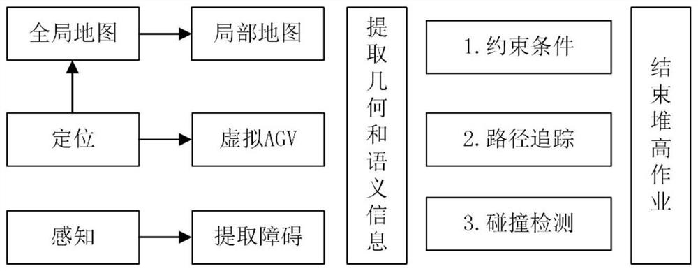
[0088] T1, AGV map module loads and extracts map data;

[0089] T2. The map module interpolates the key nodes of the driving path according to the constraints to form a smooth lane guideline 3;

[0090] T3. Use the bounding box to process the map area elements;

[0091] T4. Use kd-tree to establish the structural organization relationship between each map element;

[0092] T5. The positioning module releases the positioning information of the laser radar in real time, and informs other modules of the system of the position and heading information of the AGV;

[0093] T6. The AGV map module periodically releases the local map 15 data within a certain radius of the AGV's environment according to the positioning information released by the positioning module, so as to ...

Embodiment 3

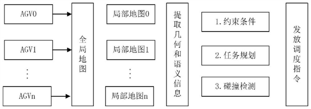
[0124] On the basis of Embodiment 2, a method for scheduling AGVs is provided, including the following steps:

[0125] D1. According to the lane information and constraint information of the map, the server uses the planning algorithm (using the existing algorithm, such as the improved Dijkstra, A * 、D * Algorithm) to plan the optimal task path for each AGV and send scheduling instructions;

[0126] D2. The map module of the server publishes the local map information of each AGV in real time according to the status and perception information of each AGV;

[0127] D3. The server detects the local map information of each AGV. When some AGVs are relatively close, the status information and geometric contour information of other AGVs will appear in the local map perspective of the current AGV. For the AGVs in the current local map 15 Collision detection is carried out between them, avoiding global detection, and improving detection efficiency and safety.


PUM


Abstract

The invention relates to the technical field of navigation scheduling and safety of intelligent AGVs, and in particular to a multi-semantic security map construction, use and scheduling method for AGVnavigation scheduling. The multi-semantic security map construction method for AGV navigation scheduling comprises the following steps: S1, collecting path key points; S2, processing the data acquired in the step S1; S3, fitting the path by utilizing the geometric attributes of the path points and map elements; S4, establishing a structural relationship between a lane boundary and a driving path;S5, carrying out multi-semantic region segmentation on the lane by utilizing map elements according to scene requirements; S6, setting different constraint information according to different regionalsemantics and establishing a structural relationship with the lane; and S7, storing the generated map. The multi-semantic digital map serves as priori knowledge, real-time semantic verification is carried out on operation behaviors and state information of the AGV, dangerous situations are avoided, and the operation safety of the AGV is guaranteed.

Description

technical field [0001] The invention relates to the technical field of navigation scheduling and security of intelligent AGVs; in particular, it relates to a construction, use and scheduling method of a multi-semantic safety map for AGV navigation scheduling. Background technique [0002] With the development of science and technology, unmanned transportation solutions in the field of logistics technology have achieved rapid development, and have been applied in a certain range of scenarios. With industrial upgrading, unmanned factories, smart factories, digital factories, and IoT factories will be demonstrated on a large scale and become a new economic growth point for Chinese manufacturing. In key links such as warehousing logistics and production line distribution in factories, the demand for automatic guided vehicles (AGV) will increase greatly, which will promote the deep integration of AGV and smart factories. This will not only provide new opportunities for traditiona...

Claims


Application Information

Patent Timeline
Patent Type & Authority Applications(China)
IPC IPC(8): G06K9/34G06K9/46G06T7/73G06T11/20G08B19/00H04W4/021H04W4/029H04W4/42G01S17/06G01C21/32
CPCG06T11/203G01S17/06G01C21/32G06T7/73G08B19/00H04W4/021H04W4/029H04W4/42G06V10/267G06V10/44
Inventor 陈超何俊熙王梅香刘剑于筱涵朱忠成
Owner 济南蓝图士智能技术有限公司
Why Eureka
Try Eureka