Sea-land integrated three-dimensional model construction method and device, storage medium and electronic equipment

A three-dimensional model and construction method technology, which is applied in the field of marine-land integrated three-dimensional model construction method, device, storage medium and electronic equipment, can solve the problems of complex marine-land three-dimensional model process and low data collection efficiency, and achieves simple and clear technical process. , the technical process is simple, the effect of high work efficiency

Pending Publication Date: 2021-04-13
中国自然资源航空物探遥感中心
View PDF0 Cites 0 Cited by
  • Summary
  • Abstract
  • Description
  • Claims
  • Application Information

AI Technical Summary

Problems solved by technology

[0006] Aiming at the deficiencies of the prior art, the present invention provides a construction method, device, storage medium and electronic equipment for an integrated three-dimensional model of land and sea, which solves the problems of complex process and low efficiency of data collection in the existing method for constructing a three-dimensional model of land and sea integration

Method used


Image

  • Sea-land integrated three-dimensional model construction method and device, storage medium and electronic equipment

Examples


Embodiment 1

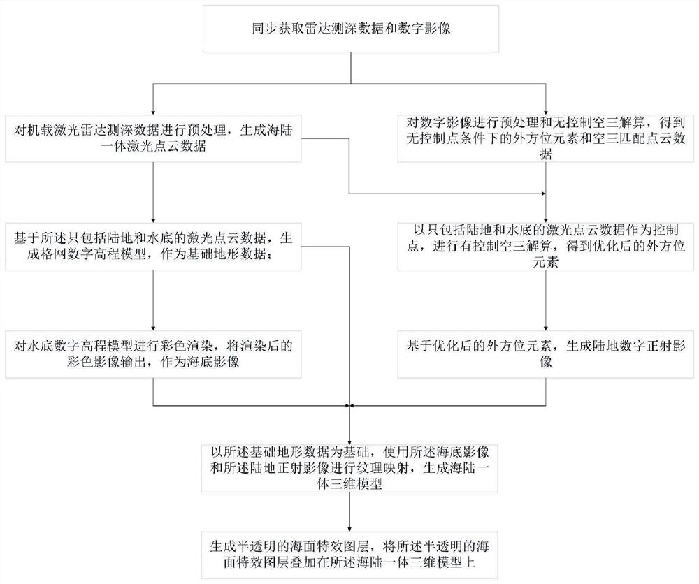
[0073] Such as figure 1 As shown, the present invention provides a method for building an integrated three-dimensional model of land and sea, the method is executed by a computer, and the method includes:

[0074] Simultaneously acquire airborne lidar bathymetric data and digital images of coastal islands and reefs;

[0075] Based on the airborne laser radar bathymetry data, basic terrain data and seabed images of an integrated three-dimensional model of land and sea are generated;

[0076] Generate land digital orthoimages based on the airborne lidar bathymetric data and digital images;

[0077] Based on the basic terrain data, the seabed image and the land orthophoto are used to perform texture mapping to generate a three-dimensional integrated model of land and sea.

[0078] The beneficial effects of this embodiment are:

[0079] 1) High work efficiency. The flight speed of the aircraft is much higher than the previous ship-borne measurement efficiency, and the airborne...

Embodiment 2

[0105] A device for constructing an integrated three-dimensional model of land and sea, the device comprising:

[0106] The data acquisition module is used to simultaneously acquire the airborne lidar bathymetric data and digital images in coastal islands and reefs;

[0107] Basic terrain data and seabed image generation module, used for generating basic terrain data and seabed image of sea and land integrated three-dimensional model based on the airborne lidar bathymetric data;

[0108] Optionally, the base terrain data and seabed image generation module generates basic terrain data and seabed images of an integrated three-dimensional model of land and sea based on the airborne lidar bathymetric data, including the following steps:

[0109] S2.1. Calculate the three-dimensional ellipsoid coordinates of the land, water surface and underwater based on the collected airborne lidar bathymetry data, aircraft positioning and attitude data and laser pointing information, and generat...

Embodiment 3

[0125] A computer-readable storage medium, which stores a computer program for building an integrated three-dimensional model of land and sea, wherein the computer program causes the computer to perform the following steps:

[0126] Simultaneously acquire airborne lidar bathymetric data and digital images of coastal islands and reefs;

[0127] Based on the airborne laser radar bathymetry data, basic terrain data and seabed images of an integrated three-dimensional model of land and sea are generated;

[0128] Generate land digital orthoimages based on the airborne lidar bathymetric data and digital images;

[0129] Based on the basic terrain data, the seabed image and the land orthophoto are used to perform texture mapping to generate a three-dimensional integrated model of land and sea.

[0130] Optionally, the basic topographic data and seabed images of the integrated three-dimensional model of land and sea are generated based on the airborne lidar bathymetric data, includi...


PUM


Abstract

The invention provides a sea-land integrated three-dimensional model construction method and device, a storage medium and electronic equipment, and relates to the technical field of sea-land integrated three-dimensional model construction. Sea-land integrated terrain and digital images are synchronously obtained through an airborne laser radar sounding technology, laser radar echoes on the land and at the water bottom can be received at the same time by adopting blue-green laser, and during data processing of software, land echoes and seabed echoes are subjected to integrated fusion processing, therefore, terrains in seamless connection with the land and the seabed can be directly generated, the land and the seabed do not need to be measured respectively, and the three-dimensional model construction efficiency is greatly improved. The sea-land integrated three-dimensional digital terrain is directly obtained by utilizing an airborne laser sounding technology, complex processing processes such as plane reference unification, vertical reference unification, data structure unification and data blank area interpolation of the land terrain and the seabed terrain are not needed, and the technical process is simple.

Description

technical field [0001] The invention relates to the technical field of building a three-dimensional model of an integrated sea and land, in particular to a method, device, storage medium and electronic equipment for building a three-dimensional model of an integrated sea and land. Background technique [0002] The integrated 3D model of land and sea first needs to obtain the digital terrain of land and sea integration, and then use remote sensing images or other images for texture mapping on the terrain data to generate a 3D digital model. [0003] In the current method, different technologies are used to collect land terrain and seabed terrain, for example, laser radar or photogrammetry is used for land terrain, and shipborne multi-beam or single-beam measurement method is used for underwater terrain, and then The land terrain and underwater terrain are integrated, and finally the image is mapped to the integrated terrain to generate a 3D model. It involves complex process...

Claims


Application Information

Patent Timeline
Patent Type & Authority Applications(China)
IPC IPC(8): G06T17/05G06T15/04G06T15/20G06T7/33
CPCG06T15/04G06T15/205G06T17/05G06T2207/10028G06T2207/10044G06T7/33
Inventor 金鼎坚吴芳李丹于坤李勇志王建超张文凯赵政张宗贵李奇冀欣阳李天祺
Owner 中国自然资源航空物探遥感中心
Why Eureka
Try Eureka