Road surface damage data space-time analysis method based on multi-source feature fusion

A damage data and feature fusion technology, applied in special data processing applications, database indexing, image data processing, etc., to achieve efficient and stable road condition detection, reliable data support, and improve detection efficiency

Active Publication Date: 2021-05-14
TONGJI UNIV
View PDF5 Cites 12 Cited by
  • Summary
  • Abstract
  • Description
  • Claims
  • Application Information

AI Technical Summary

Problems solved by technology

In addition, the current pavement state data still lacks a complete record of the influencing factors. The change of the pavement state is the result of the coupling of multiple factors such as traffic load and natural environment. A true and complete record of the change of each influencing factor is also a necessary condition for big data analysis.

Method used


Image

  • Road surface damage data space-time analysis method based on multi-source feature fusion
  • Road surface damage data space-time analysis method based on multi-source feature fusion
  • Road surface damage data space-time analysis method based on multi-source feature fusion

Examples


Embodiment

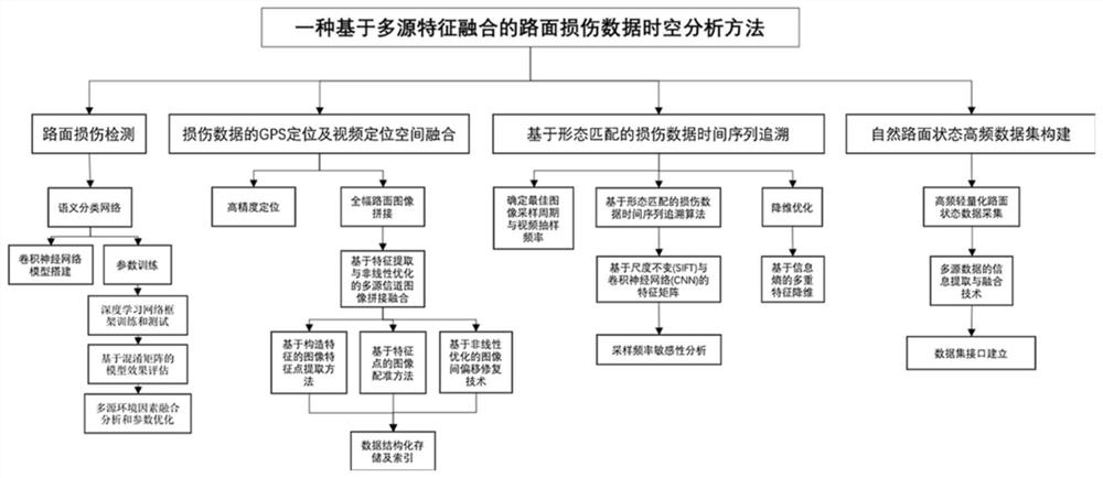
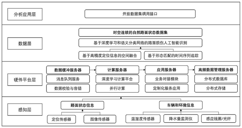
[0040] The invention relates to a spatiotemporal analysis method of pavement damage data based on multi-source feature fusion, such as figure 1 As shown in the figure, it includes a pavement damage detection step, a GPS positioning of damage data and a spatial fusion of video positioning, a time series tracing of damage data based on morphological matching, and a high-frequency data set construction step of natural road conditions. In order to realize each step, the method of the present invention is realized based on a layered framework, such as figure 2 shown, including the following:

[0041] 1) Perception layer: use positioning sensors and image sensors to obtain road status information; use temperature and humidity sensors, precipitation monitors, induction coils / optical fibers to obtain vehicle and environmental information.

[0042] 2) Hardware platform layer: use the data buffer server to aggregate data, and implement message queue service and data checksum fault tol...


PUM


Abstract

The invention relates to a road surface damage data space-time analysis method based on multi-source feature fusion, which comprises the following steps: road surface damage detection: capturing image data of local anomaly and disease of a road surface by adopting a semantic classification network, and detecting a classification result of an abnormal condition of the road surface; performing GPS positioning and video positioning space fusion of damage data, and establishing a global road surface coordinate system through a multivariate road section image splicing algorithm and by realizing multi-source image data fusion; tracing a damage data time sequence based on form matching, extracting road surface damage features under the time sequence, taking rough matching of spatial position features as a basis, and simultaneously matching high-frequency images acquired for multiple times; and constructing a natural pavement state high-frequency data set, including high-frequency lightweight pavement state data acquisition, multi-source data information extraction and fusion technology and data set interface establishment. Compared with the prior art, the invention has the advantages that the anti-interference capability is high, and the timeliness of pavement maintenance and management is improved.

Description

technical field [0001] The invention relates to the technical field of road maintenance, in particular to a spatiotemporal analysis method of pavement damage data based on multi-source feature fusion. Background technique [0002] With the passage of time and the increase of the total number of facilities, the demand for highway maintenance in my country has shown a rapid growth trend. The development of large-scale maintenance work and the improvement of related technical research are inseparable from the support of comprehensive and accurate testing data. Although the overall evolution of the pavement state is long-term, the generation or development of meso-micro damage is sudden. The low-frequency detection is not time-sensitive, and it is difficult to observe the change process completely. It is necessary to pass high-frequency and time-sensitive detection data to ensure the accuracy of the identification of the development trend of the road surface. [0003] With the...

Claims


Application Information

Patent Timeline
Patent Type & Authority Applications(China)
IPC IPC(8): G06K9/00G06K9/62G06N3/08G06T3/40G06F16/22G06F16/2458
CPCG06N3/08G06T3/4038G06F16/2228G06F16/2474G06F16/2465G06V20/00G06F18/22G06F18/2414G06F18/253G06F18/214
Inventor 杜豫川潘宁刘成龙吴荻非刘浩蒋盛川
Owner TONGJI UNIV
Why Eureka
Try Eureka