Conventional water quality monitoring system and method based on remote sensing waveband combination

A water quality monitoring system, water quality monitoring technology, applied in the direction of image detector method and image signal processing, general water supply saving, measuring device, etc., can solve the problem of model accuracy reduction, influence on fitting or training direction, narrow adaptation range, etc. problem, to achieve the effect of increasing accuracy and goodness of fit, reliability and stability, applicability and reusability

Active Publication Date: 2021-11-23
重庆星视空间科技有限公司
View PDF11 Cites 0 Cited by
  • Summary
  • Abstract
  • Description
  • Claims
  • Application Information

AI Technical Summary

Problems solved by technology

[0003] However, in the existing technology, satellite remote sensing data such as single-spectrum and multi-spectrum are mainly used to invert conventional water quality data. The existing problems are: (1) The inversion model is simple to choose, and most models consider the linear fitting method. The exponential fitting method is used, and a small part chooses the basic model of the machine learning algorithm
Using simple models for water quality fitting (even the parallelization of multiple simple models) will lead to narrow adaptation range, poor universality, and finally only one or two types of water quality inversion can be realized, and cannot adapt to special water quality (such as abnormal water quality) (2) The remote sensing band used by the inversion model is single, and most of the existing technologies choose a band with the strongest correlation or a simple combination of one or two bands. For example, the Sentinel-2 satellite has 12 bands to choose from. The utilization rate of model data is low. If the selected single band or one or two bands have a large error, for example, the selected band does not reflect the error of the acquisition section very well (while other bands that are not selected can often reflect), However, when the cloud image re-inspection step is not performed, using this band data for conventional water quality fitting will cause great interference to the model fitting, and the error term caused by this situation cannot be corrected, and the entire set of data can only be eliminated. The accuracy of the model is reduced, and the goodness of fit is deteriorated; (3) The band data input to the inversion model lacks a cloud map retest step, so that the model often uses wrong remote sensing data for fitting or training, resulting in one or more A point on an error section affects the fitting or training direction of the entire model
And only analyze the band data, whether it is in the form of a table or a database, the results without visual verification using satellite maps are unreliable. Using such band data for fitting, the results of the model output are different from the actual large, unreliable

Method used


Image

  • Conventional water quality monitoring system and method based on remote sensing waveband combination
  • Conventional water quality monitoring system and method based on remote sensing waveband combination
  • Conventional water quality monitoring system and method based on remote sensing waveband combination

Examples


Embodiment Construction

[0031] In order to make the purpose, technical solution and advantages of the present invention clearer, the present invention will be further described in detail below through specific implementation methods in conjunction with the accompanying drawings. It should be understood that the specific embodiments described here are only used to explain the present invention, not to limit the present invention.

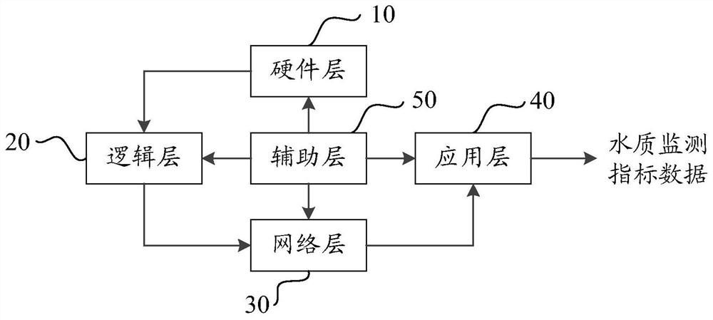
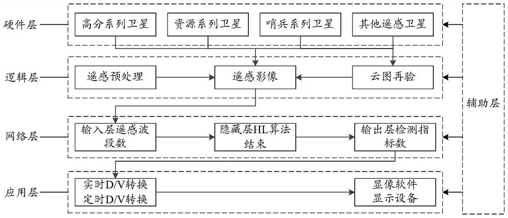
[0032] In one embodiment, such as figure 1 and figure 2As shown, a kind of conventional water quality monitoring system based on remote sensing band combination is provided, comprising: hardware layer 10, logic layer 20, network layer 30 and application layer 40; hardware layer 10 is connected with logic layer 20, and logic layer 20 is connected with network layer 30, the network layer 30 is connected with the application layer 40; the hardware layer 10 includes multiple satellites, through which the remote sensing band data is obtained and sent to the logical layer 20; t...


PUM


Abstract

The invention provides a conventional water quality monitoring system and method based on remote sensing waveband combination, and the system comprises a hardware layer, a logic layer, a network layer, and an application layer. The hardware layer is connected with the logic layer, the logic layer is connected with the network layer, and the network layer is connected with the application layer; the hardware layer comprises a plurality of satellites, and remote sensing waveband data are obtained through the satellites; remote sensing preprocessing is performed on the remote sensing wave band data through the logic layer, and cloud picture rechecking processing is performed on the filtered remote sensing wave band data by adopting a parallel thread pool to obtain remote sensing image data; the network layer calculates the remote sensing image data based on a Bayesian linear regression model to obtain ground data; and the application layer performs real-time or timed data visualization conversion on the ground data and the remote sensing image data to obtain and store water quality monitoring index data. According to the invention, the universality, accuracy, reliability and stability of the system can be ensured.

Description

technical field [0001] The invention relates to the technical field of water quality monitoring, in particular to a conventional water quality monitoring system and method based on remote sensing band combination. Background technique [0002] With the continuous development of remote sensing technology, remote sensing technology is more and more used in the field of water quality monitoring. As a regional monitoring method, remote sensing technology can overcome the shortcomings of conventional water quality monitoring methods. The calculation of water quality parameters using remote sensing data is essentially a process of calculation based on a preset inversion model. [0003] However, in the existing technology, satellite remote sensing data such as single-spectrum and multi-spectrum are mainly used to invert conventional water quality data. The existing problems are: (1) The inversion model is simple to choose, and most models consider the linear fitting method. The e...

Claims


Application Information

Patent Timeline
Patent Type & Authority Applications(China)
IPC IPC(8): G01N21/17G01N21/31G01N21/3577
CPCG01N21/17G01N21/31G01N21/3577G01N2021/1793G01N2021/1765Y02A20/152
Inventor 邓贵源邓平阳春花刘泽飞陈杰邹景强
Owner 重庆星视空间科技有限公司
Why Eureka
Try Eureka