Complex microtopography recognition and power transmission line windage yaw calculation method based on elevation image

A technology of transmission lines and calculation methods, which is applied in the field of power transmission and distribution, and can solve problems such as large wind speed deviations

Active Publication Date: 2021-12-21
STATE GRID JIANGXI ELECTRIC POWER CO LTD RES INST +2
View PDF4 Cites 0 Cited by
  • Summary
  • Abstract
  • Description
  • Claims
  • Application Information

AI Technical Summary

Problems solved by technology

The influence of topographical factors on wind speed due to complex micro-topography leads to a large deviation between the actual wind speed at the height of the transmission line and the wind speed in the flat area, resulting in a certain gap between the wind displacement of the line

Method used


Image

  • Complex microtopography recognition and power transmission line windage yaw calculation method based on elevation image
  • Complex microtopography recognition and power transmission line windage yaw calculation method based on elevation image
  • Complex microtopography recognition and power transmission line windage yaw calculation method based on elevation image

Examples


Embodiment Construction

[0043] A complex micro-terrain recognition and transmission line wind deviation calculation method based on elevation images,

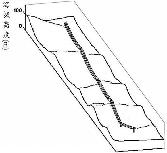
[0044] Step 1. Obtain the elevation image of the terrain of the transmission line erection site, the latitude and longitude coordinates of the tower, the model of the tower, and the local meteorological data;

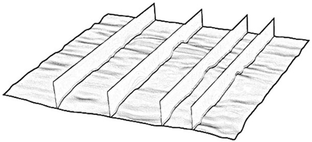
[0045] Step 2. Use the global digital elevation model ASTER GDEM V2 version software to collect the geographical data of the transmission line erection site area, and obtain the digital elevation data map after processing: use the global digital elevation model to collect, process and analyze the geographical data of the area where the transmission line is located, Export the terrain data map of the area where the transmission line is located, intercept the initial terrain image according to different altitudes, obtain RGB images corresponding to different heights, and then perform grayscale processing on the image, convert the RGB image into a ...


PUM


Abstract

The invention discloses a complex microtopography recognition and power transmission line windage yaw calculation method based on an elevation image, and the method comprises the steps: collecting the geographic data of a region where a power transmission line is located to build a three-dimensional model in consideration of the influence of the topographic factor of the region where the power transmission line is located on the wind speed; carrying out the wind field simulation on the topographic three-dimensional model through finite element analysis software, to obtain the actual wind speed of the complex microtopography; and finally, learning and training a large number of topographic three-dimensional models and wind field simulation results thereof by using a support vector machine algorithm to realize intelligent recognition and prediction of the actual wind speed of the complex microtopography, and substituting the obtained actual wind speed into a windage yaw calculation formula of the power transmission line to calculate the windage yaw angle and the windage yaw displacement of a wire under the specific mountain terrain. The method is suitable for most typical complex mountain microtopography, the actual wind speed of the height where the wire is located is intelligently recognized, and therefore the technical scheme of complex microtopography power transmission line design is optimized, and the working efficiency and the safety and reliability of the line are greatly improved.

Description

technical field [0001] The invention relates to a complex micro-topography recognition method based on an elevation image and a wind deflection calculation method of a power transmission line, which belongs to the technical field of power transmission and distribution. Background technique [0002] The increase in the voltage level of my country's power grid has made long-distance power transmission possible, and the long-distance erection of transmission lines cannot avoid mountainous areas with complex terrain. The influence of topographic factors of complex micro-topography on wind speed leads to a large deviation between the actual wind speed at the height of the transmission line and the wind speed in the flat area, resulting in a certain gap in the wind displacement of the line. Therefore, the influence of mountain topography on wind speed should be considered when constructing transmission lines, which will greatly reduce the probability of wind deflection failure of ...

Claims


Application Information

Patent Timeline
Patent Type & Authority Applications(China)
IPC IPC(8): G06F30/18G06F30/23G06F30/27G06K9/00G06K9/62G06F113/06G06F119/14
CPCG06F30/18G06F30/23G06F30/27G06F2113/06G06F2119/14G06F18/214G06F18/2411
Inventor 邹丹旦涂忱胜宋子浔饶斌斌余霜鸿胡京张宇
Owner STATE GRID JIANGXI ELECTRIC POWER CO LTD RES INST
Why Eureka
Try Eureka