
Satellite radiometric calibration method for collaborating crowd source data

A radiation calibration and data technology, applied in the field of remote sensing, can solve problems such as difficulty in obtaining absolute radiation calibration data, difficulty in data screening, and inconsistent types, and achieve the effect of improving experimental efficiency and calibration accuracy

Active Publication Date: 2022-06-07
自然资源部国土卫星遥感应用中心
View PDF5 Cites 1 Cited by
  • Summary
  • Abstract
  • Description
  • Claims
  • Application Information

AI Technical Summary

Problems solved by technology

[0004] In order to solve the above technical problems, the present invention solves the problem that the current absolute radiation calibration data is difficult to obtain, the formats and types of data from different data sources are not uniform and the data screening is difficult. Technical problems such as low experimental efficiency

Method used


Image

  • Satellite radiometric calibration method for collaborating crowd source data
  • Satellite radiometric calibration method for collaborating crowd source data
  • Satellite radiometric calibration method for collaborating crowd source data

Examples


Embodiment Construction

[0022] In order to make the objectives, technical solutions and advantages of the present invention clearer, the present invention will be described in further detail below with reference to the embodiments and accompanying drawings.

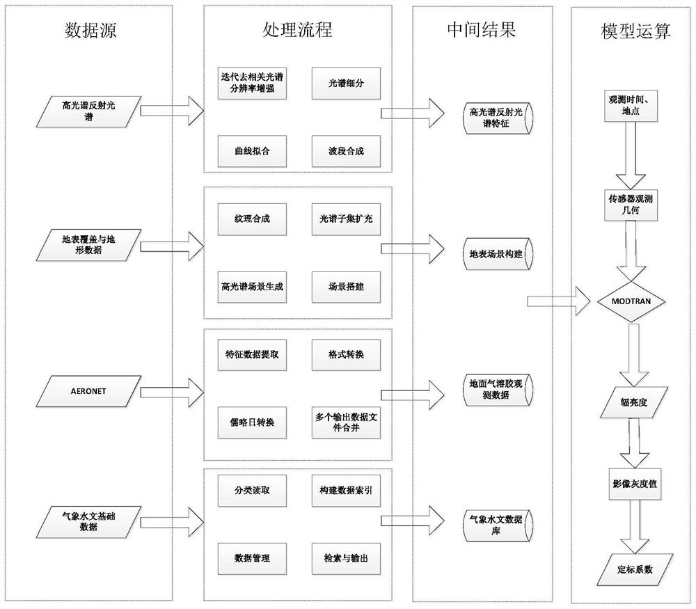
[0023] like figure 1 As shown, it is a schematic flowchart of the satellite radiation calibration method for collaborative crowd-source data, including:

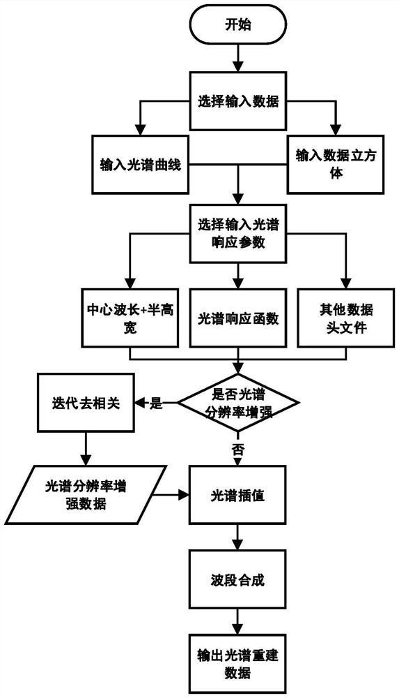
[0024] 1) Reconstruction of spectral features of hyperspectral reflectance

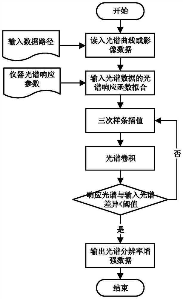
[0025] The measurement process of hyperspectral instruments has an average effect on spectral characteristics. The data measured by different hyperspectral instruments are affected differently by the spectral response of the instrument, and the spectral characteristics are different, which affects the quantitative application ability of the data. Therefore, it is necessary to perform spectral resolution enhancement and spectral feature reconstruction on the spectral curve data and hyperspectral image data obtained by...


PUM


Abstract

The invention discloses a satellite radiation calibration method for collaborating crowd source data. The satellite radiation calibration method comprises the following steps: performing spectral resolution enhancement and spectral feature reconstruction for different measurement data and hyperspectral image data; fusing the high-resolution remote sensing image, the ground feature spectrum library, the topographic data and the surface temperature multi-dimensional data to realize surface coverage and topographic data scene construction; obtaining aerosol data, analyzing and screening the data, and extracting a text format; by constructing a user data file interface, data is stored in a corresponding database according to an index format, and meteorological and hydrological data searching is achieved; simulation of the radiance of the sensor is realized by using a radiation transmission model according to spectral data, earth surface coverage and topographic data, aerosol data and meteorological and hydrological data, and linear fitting with an image gray value is carried out to obtain a calibration coefficient. According to the invention, mass source data are integrated, rapid extraction of data such as ground feature spectrum, atmosphere, earth surface coverage and terrain, hydrology and the like and batch processing of radiation transmission models are realized, and the experimental efficiency and precision of absolute radiometric calibration are improved.

Description

technical field [0001] The invention relates to the field of remote sensing technology, in particular to a satellite radiation calibration method for collaborative crowd-source data. Background technique [0002] With the increasing development of remote sensing, more and more remote sensing products are continuously applied in national key research projects such as national defense, agriculture, forestry, and land use. Radiometric calibration is a key step to realize remote sensing quantification. Absolute radiometric calibration is to convert the gray value of remote sensing images into practical radiance or atmospheric top reflectance. At present, absolute radiometric calibration is mainly divided into: laboratory radiometric calibration. Calibration, on-board calibration, site calibration, etc. The remote sensing satellite sensors need to be calibrated in the laboratory to obtain the calibration coefficient of the laboratory radiation before they are launched. It is ne...

Claims


Application Information

Patent Timeline
Patent Type & Authority Applications(China)
IPC IPC(8): G01S19/23
CPCG01S19/23Y02A90/10
Inventor 唐洪钊唐新明窦显辉谢俊峰王恒阳陈辉莫凡朱广彬
Owner 自然资源部国土卫星遥感应用中心
Learn More