Inversion method for near-land shallow sea underwater topography

An underwater terrain and inversion technology, which is applied in the field of underwater terrain inversion in coastal and shallow waters, can solve the problems of being easily affected by practical factors, time-consuming and labor-intensive, so as to improve regional applicability and reliability, and improve product quality. effect with degree of automation

Pending Publication Date: 2022-07-08
陕西九州遥感信息技术有限公司 +2
View PDF0 Cites 1 Cited by
  • Summary
  • Abstract
  • Description
  • Claims
  • Application Information

AI Technical Summary

Problems solved by technology

[0005] The present invention aims to solve the limitations of the prior art that "it is difficult to go to the beach by ship survey and difficult to go to sea by land survey", the traditional method of measuring water depth is time-consuming and labor-intensive and is easily affected by actual factors, and the traditional water depth inversion algorithm requires sea surface roughness, In order to improve the quality and automation of water depth inversion products, we provide a method for inversion of underwater terrain in coastal shallow seas in order to solve problems such as limitations of meteorological data and other data.

Method used


Image

  • Inversion method for near-land shallow sea underwater topography
  • Inversion method for near-land shallow sea underwater topography
  • Inversion method for near-land shallow sea underwater topography

Examples


Embodiment Construction

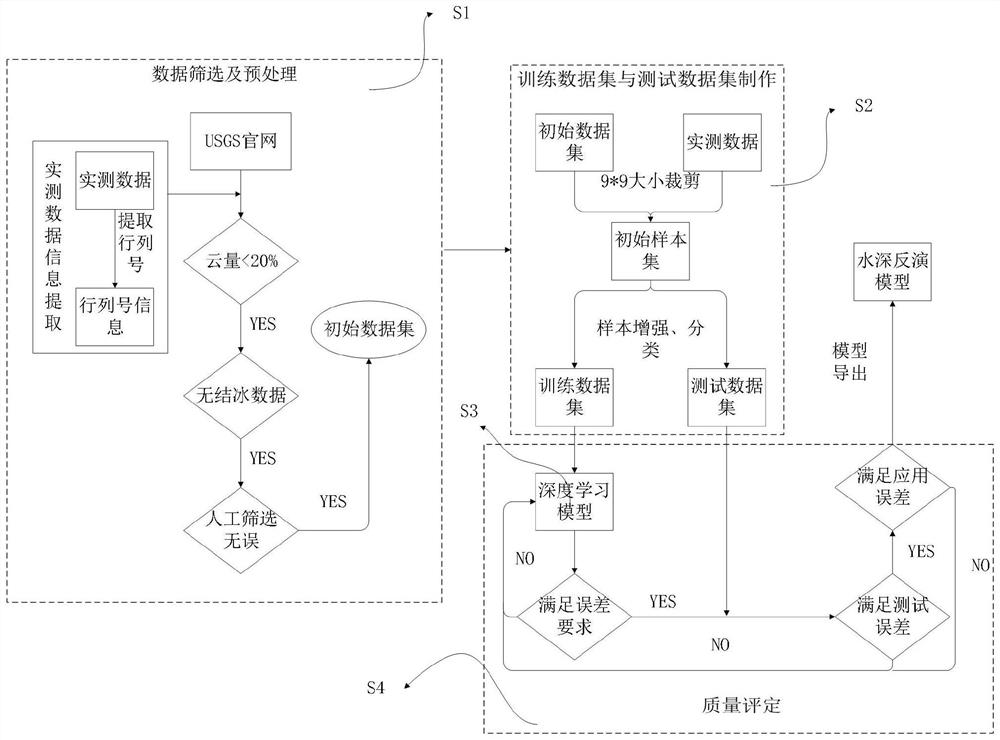
[0037] In order to more clearly understand the above objects, features and advantages of the present invention, the present invention will be further described below with reference to the accompanying drawings and embodiments. Numerous specific details are set forth in the following description to facilitate a full understanding of the present invention, however, the present invention may also be practiced in other ways than described herein, and therefore, the present invention is not limited to the specific embodiments disclosed below.

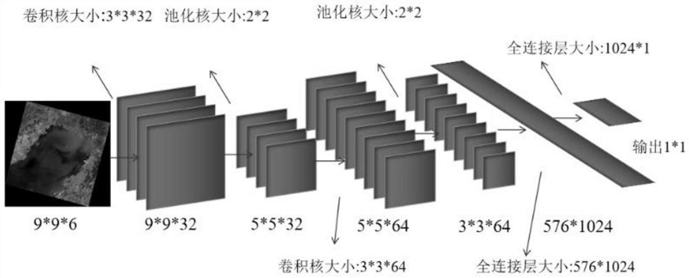
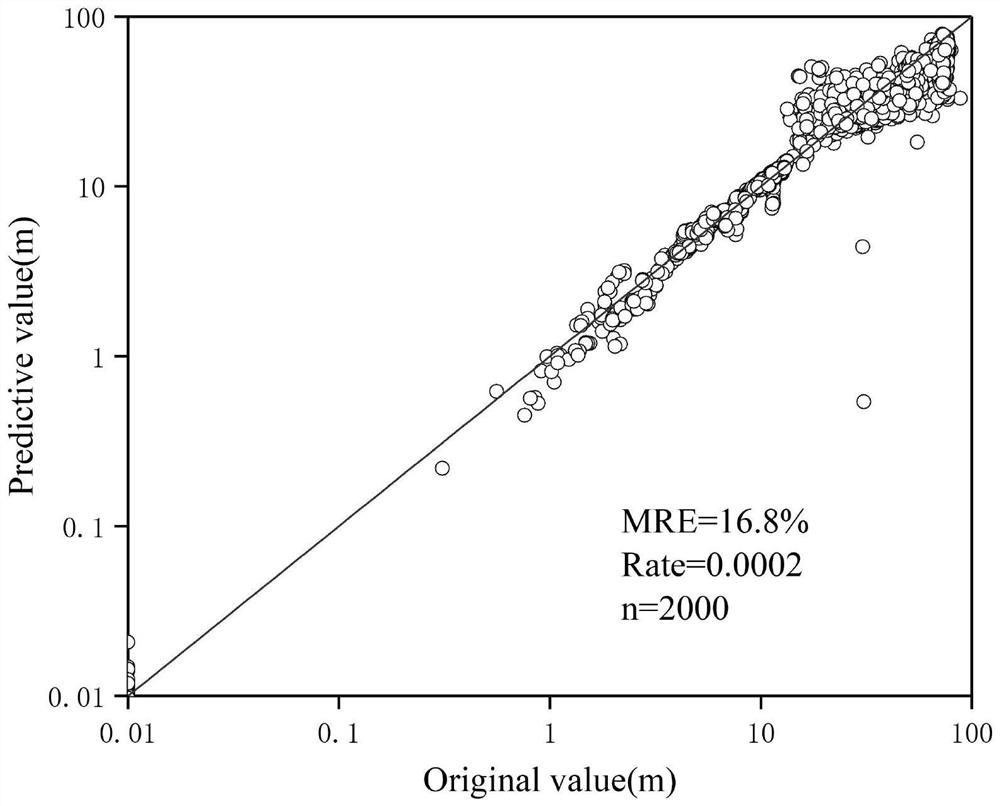
[0038] Remote sensing images contain a lot of information. In visible light remote sensing, the near-infrared band has a good absorption effect on water bodies. In microwave remote sensing, the response of seabed topography on the image can be observed intuitively. Considering the important controlling effect of underwater topography on the spatial distribution pattern of optical properties of water bodies in coastal waters and the strong or ...


PUM


Abstract

The invention discloses a near-land shallow sea underwater topography inversion method, which realizes high-precision inversion of near-land shallow sea underwater topography under the support of a remote sensing theory and a deep learning technology based on a remote sensing and deep learning mode. The inversion method comprises the steps of constructing a model on the basis of a convolutional neural network, constructing a deep learning model by screening common parts of multi-source data and making samples through a series of processing, and training the model on the basis of coastal measured data and by taking a multiband remote sensing image as an input to achieve an expected effect. Physical information contained in the remote sensing image is fully considered, the mapping relation of the N * N sample window images is established on the basis of the measured data, and the limitation that a traditional water depth measurement method is time-consuming and labor-consuming and is easily influenced by actual factors is overcome. The limitation that a traditional water depth inversion algorithm needs various data such as sea surface roughness and meteorological data as supports is overcome, and the quality and the automation degree of a water depth inversion product are improved; the method is easy to implement and can be used for dynamically monitoring and improving the quality of water depth products.

Description

technical field [0001] The invention belongs to the field of quantitative remote sensing and deep learning, and in particular relates to an underwater terrain inversion method in coastal shallow waters. Background technique [0002] The coastal sea area is greatly affected by natural and human factors. Artificial reclamation changes the marine ecology, tidal action drives the movement of bottom sediment, plate movement causes changes in the bottom topography, and the existence of trenches and ridges causes changes in sea surface morphology. Products that can fully consider these influencing factors are of great significance to scientific research. [0003] Due to the particularity of near-shore areas, basic hydrology and topographic observations have long had the problem of "difficulty in going to the beach by ship and difficult to go to sea by land survey". Among them, the traditional bathymetry method usually adopts the bathymetry instrument carried by the ship for measur...

Claims


Application Information

Patent Timeline
Patent Type & Authority Applications(China)
IPC IPC(8): G06V20/13G06V10/774G06K9/62G06V10/82G06N3/04G06N3/08
CPCG06N3/08G06N3/045G06F18/214Y02A10/40
Inventor 张磊陈军孙记红张青
Owner 陕西九州遥感信息技术有限公司
Why Eureka
Try Eureka