Methods and apparatus for providing a configurable geospatial data provisioning framework

a geospatial data and configuration technology, applied in the field of methods and apparatus for providing a configurable geospatial data provisioning framework, can solve the problems of inability to realize the potential effectiveness of information, difficulty in reducing errors, and difficulty in reducing so as to reduce errors and reduce the skill level of the end user.

Inactive Publication Date: 2007-08-23
SPADAC
View PDF9 Cites 45 Cited by
  • Summary
  • Abstract
  • Description
  • Claims
  • Application Information

AI Technical Summary

Benefits of technology

[0010] Accordingly, a typical conventional geospatial data request takes the form of a user query indicative of a particular area and type of output image or map. Such conventional requests typically employs a GIS or remote sensing specialist familiar with the relevant data sets and trained in the applicable image processing operations. Such a request may be, for example, an operation combining three dimensional elevation data with ground permeability to identify likely flood areas due to be used by a real estate developer or insurance company. Another example might illustrate a shift over time (temporal), such as an operation which detects the changes in vegetation over time for a specific area which could be used to illustrate the effect of a polluted river. However, the conventional end user requesting the data does not possess the expertise to create these datasets themselves and therefore relies on the skills of a third party. The end user therefore experiences an often lengthy lag time in fulfilling the data request, conveying the request to the GIS specialist, and waiting for the GIS specialist to process it from the raw imagery. Further, a discrepancy or misunderstanding may result in an erroneous or inaccurate result, compounding the lag time due to repeated and / or refined efforts. Accordingly, users may anticipatorily request geospatial data output on the mere potential to need such output at a future time. Such preemptory requests tend to increase the overall workload, increase response time for all requests, and result in output geospatial data sets which are likely to be “mothballed,” or passively stored, until obsolete or not relevant to the matter for which they were procured.
[0012] Therefore, because of the costs involved with processing and managing geospatial data, the raw data sets and resulting synthesized output sets are viewed as an important asset by the organizations maintaining and providing such geospatial output to the consumers of the data. Accordingly, geospatial data sets are the subject of license, maintenance, and ownership agreements of substantial value. By some accounts, as much as 2% of all Federal spending is directed toward acquisition, storage, and processing of geospatial data. Accordingly, it would be beneficial to provide a system and method for provisioning geospatial data to facilitate delivery of the output geospatial data set as a product to the end user as one method of increasing the utilization of the assets, reducing duplicity and reducing overall asset management costs.
[0014] The spatial data provisioning process consists of several integrated components. A data catalog records the attributes of specific data sources and stores this information in a relational database system indexed based on the geographical location of each asset. The catalog provides search and retrieval capabilities based on spatial, temporal and the various data attributes. The geospatial data is typically stored in its original source format—both in file format and spatial context, and is then provisioned specific to the needs of each end user. In this sense, provisioning includes certain image manipulations, or geospatial operations, to reprocess, reproject, resample, reformat and combine various datasets in rapid fashion. Centralized business logic rules, or transformation rules, apply to the creation of specific derivative data sets to automate repetitive and complex image creation requests. These business rules are linked to specific types of data or combinations of data and are accessed based on the policies of each organization. The application of these business rules to the geospatial assets reduce errors, assure consistency, reduce the required end user skill level and generally allow end users to easily integrate these assets into traditional decision support operations. In this manner, spatial data provisioning as discussed herein represents the next generation of managing and disseminating spatial data.

Problems solved by technology

With conventional geospatial data, the issues surrounding management can become particularly complex and expensive acute due to the size of the data and the computationally intensive operations typically associated with the geospatial data.
With respect to conventional geospatial data assets, such issues typically include acquisition, processing, and management of the conventional geospatial data to mitigate duplication and redundancy of data logistics, computation, and delivery of the resulting data product to a data consumer organization (internal or external).
Since purchasing, or acquisition of conventional geospatial data can be costly, it is typically justified based on a specific mission or project.
Costs may be optimized through contracting methods, however in many cases, the purchasing stakeholders do not identify other stakeholders within the organization before purchasing data.
In many cases, geospatial assets could be effectively leveraged throughout an organization at all levels of the business but due to traditional management and dissemination challenges, the potential effectiveness of the information cannot be realized.
These special processing tasks lead to additional, costs as the data is often output into formats specific only to the project specified by one group of stakeholders.
Although contracting the processing in most cases is more cost-effective than doing the work in-house, there may be cases where processing the data renders the result unusable by other organizations, thus reducing the ability to share costs and elevate the data to an enterprise use level.
Further, conventional data management for these large volumes of data can be very costly and can be prohibitive for some organizations.
Specifically with large imagery archives, building highly available and redundant archive systems add to the complexity and costs of effectively managing these assets.
Although the acquisition and processing costs for an asset may only occur once, management costs are recurring and increase over time.
The synthesizing operations typically require significant manual efforts, and require substantial time and computational resources to compute.
These operations create derivative datasets which are close to the original but differ due to errors called resampling.
Geospatial data typically involves very large data sets which are cumbersome, complex and computationally intensive to process.
However, the conventional end user requesting the data does not possess the expertise to create these datasets themselves and therefore relies on the skills of a third party.
The end user therefore experiences an often lengthy lag time in fulfilling the data request, conveying the request to the GIS specialist, and waiting for the GIS specialist to process it from the raw imagery.
Further, a discrepancy or misunderstanding may result in an erroneous or inaccurate result, compounding the lag time due to repeated and / or refined efforts.
Such preemptory requests tend to increase the overall workload, increase response time for all requests, and result in output geospatial data sets which are likely to be “mothballed,” or passively stored, until obsolete or not relevant to the matter for which they were procured.
Accordingly, conventional geospatial data provisioning may limit a user to a predefined set of operations for performing on the available geospatial data sets.
Such a predetermined set may not be entirely congruent to each user's needs, or may not generate geospatial output data sets in an optimal form.
These security constraints include the ability to define which users or group of users are permitted to execute the provisioning processes specific to each algorithm.

Method used


Image

  • Methods and apparatus for providing a configurable geospatial data provisioning framework
  • Methods and apparatus for providing a configurable geospatial data provisioning framework
  • Methods and apparatus for providing a configurable geospatial data provisioning framework

Examples


Embodiment Construction

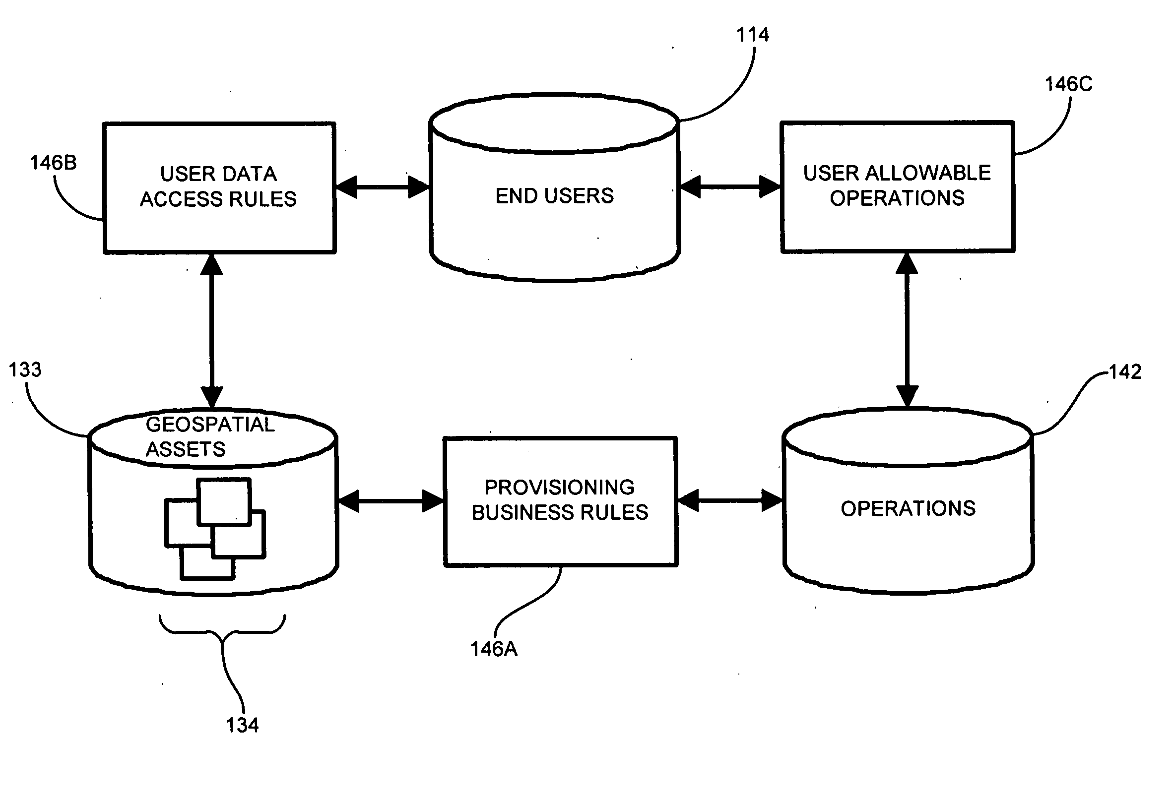
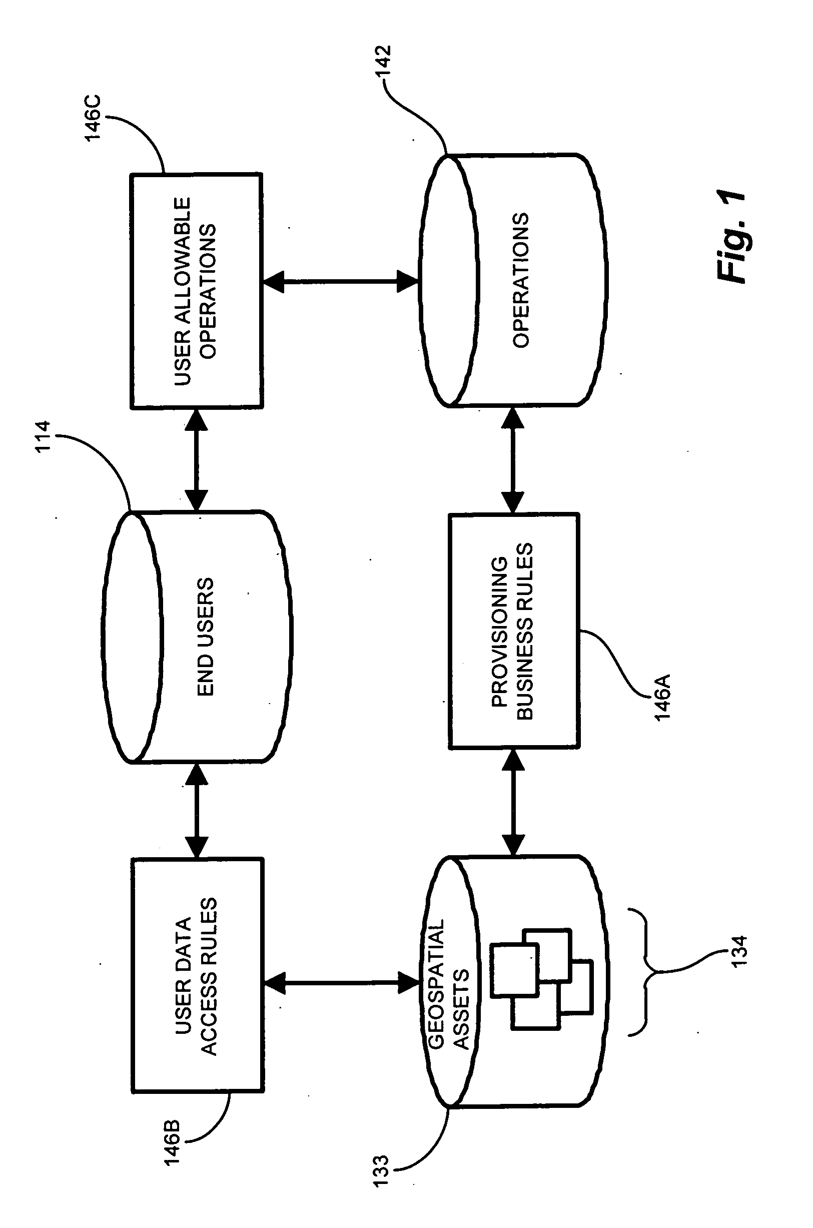
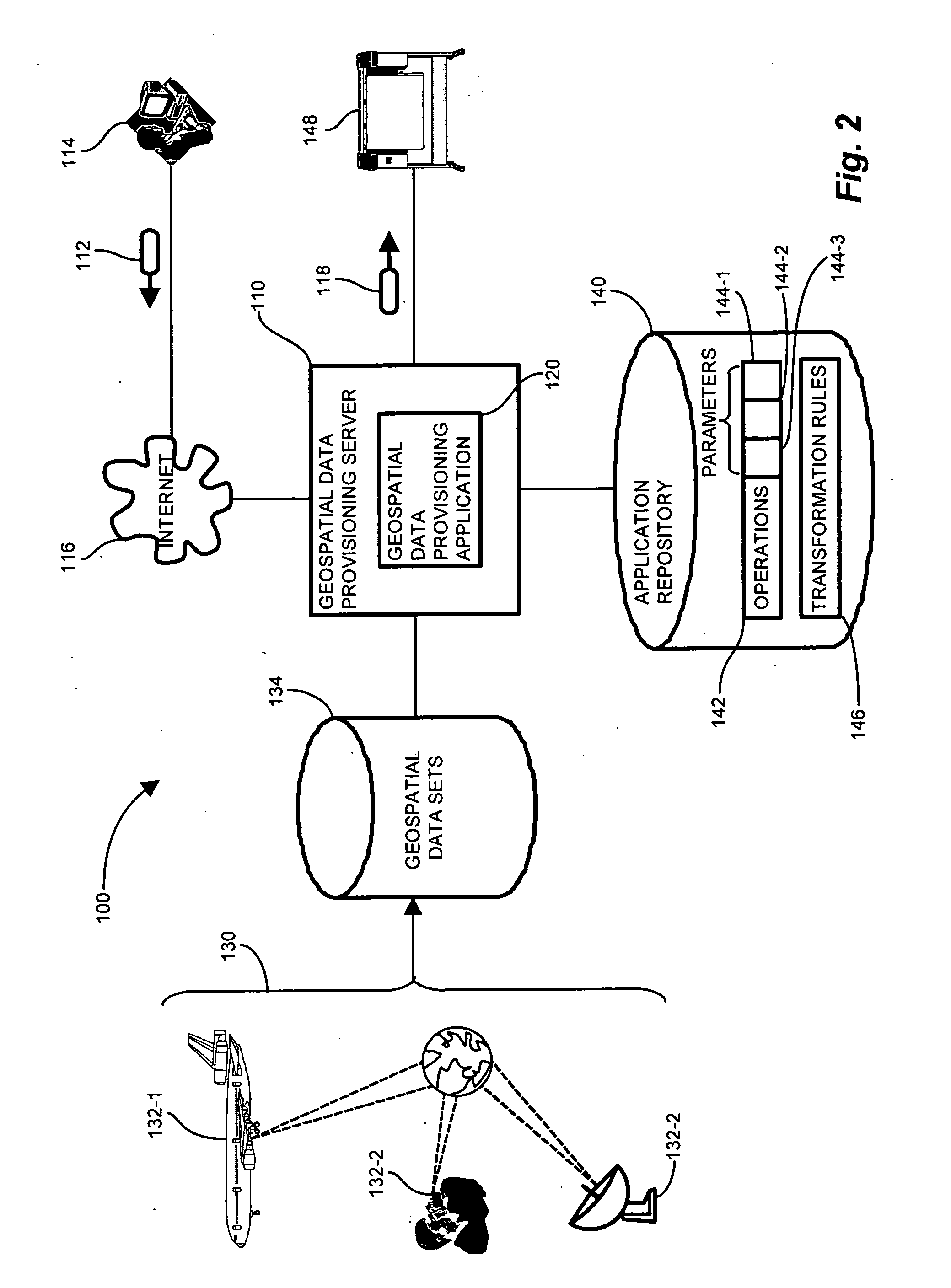
[0044] Configurations discussed further below provision geospatial data in such a manner that users may search for existing available geospatial data sets concerning an area of interest, define available geospatial operations for the geospatial data sets by selecting in a point-and-click manner, and generate the resulting geospatial output data sets by applying the selected geospatial operations to the data sets. The interactive geospatial data provisioning application provides a graphical user interface operable to present a map of geographic regions and the corresponding geospatial data sets available. The user selects the area of interest by searching, panning and zooming over the mapped regions which outline and identify portions covered by the available geospatial data sets. The geospatial data provisioning application identifies geospatial data sets within the area of interest. By analyzing the attributes available in the identified geospatial data sets, the geospatial data pr...


PUM


Abstract

An interactive geospatial data provisioning application presents a graphical user interface operable to present a map of geographic regions and corresponding geospatial data sets. The user selects the area of interest from the mapped regions corresponding to the available geospatial data sets. The application identifies geospatial data sets within the area of interest. By analyzing the attributes available in the identified geospatial data sets, the geospatial data application determines the operations applicable to the data sets. A set of transformation rules computes the operations available for a particular selection of geospatial data sets. A custom plugin generator allows a user to define and insert geospatial operations into the provisioning sequence. The application presents the available predefined and user defined operations, and the user select the geospatial data operations to apply from among the available operations. The geospatial data provisioning application applies the selected operations to the identified geospatial data sets.

Description

RELATED APPLICATIONS [0001] This application claims the benefit under 35 U.S.C. § 120 of copending patent application Ser. No. 10 / 990,205, filed Nov. 16, 2004, entitled “SYSTEM AND METHODS FOR PROVISIONING GEOSPATIAL DATA” (Atty. Docket No. SNZ04-01), incorporated herein by reference in entirety.BACKGROUND OF THE INVENTION [0002] In a typical business enterprise, the notion of data, or the collective intellectual property of employee knowledge, constitutes one of the key assets of any organization. As a key asset, data must be properly leveraged and managed according to its usage and impact to the organization. Not all data is created equally, and every organization values specific types of data more than others. Many organizations characterize their data based on its importance, which translates to the amount of money and resources spent in acquisition, management, and maintenance. Once an organization has determined the relevance of certain data assets, the organization can develo...

Claims


Application Information

Patent Timeline
Patent Type & Authority Applications(United States)
IPC IPC(8): G06F7/00
CPCG06Q10/00G06F17/30241G06F16/29
Inventor HARDY, MARKBARKER, PHILIPKOCH, MARK
Owner SPADAC
Why Eureka
Try Eureka