
Systems and methods for space-time determinations with reduced network traffic
a space-time determination and network traffic technology, applied in the field of object positioning systems, can solve the problems of no reliable solution, large inaccurate positioning data, and lack of gps signals in places
- Summary
- Abstract
- Description
- Claims
- Application Information
AI Technical Summary
Problems solved by technology
Method used
Image

Examples
example embodiment
[0045 Using Pung Messages
[0046]The following description presents a specific implementation of the computations performed and solutions generated to achieve overall system operation using pung messages according to one embodiment.
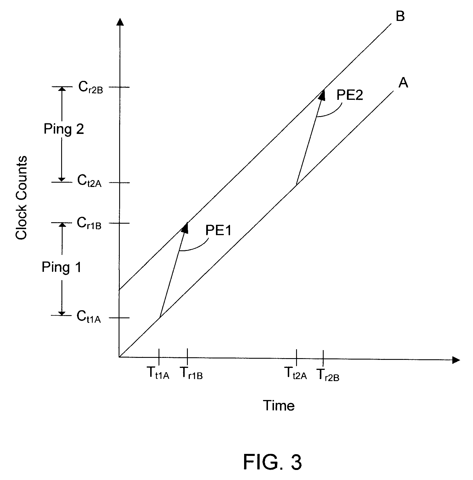
[0047]FIG. 3 is a graph showing clock counts corresponding to two time-displaced ping events transmitted from node A and received by node B under conditions in which nodes A and B are the same distance apart from each other during two ping events. With reference to FIG. 3, a vector PE1 represents a first ping event, which has a clock count value, Ping 1, expressed as
Ping 1=Cr1B−Ct1A, (1)
where Ct1A is a clock count (or count stamp) accumulated by a counter (e.g., counter 214 shown in FIG. 2) driven by a digital clock residing at node A and transmitted by node A at a time, Tt1A, and Cr1B is a clock count (or count stamp) accumulated by a counter driven by a digital clock residing at node B and associated with a time, Tr1B, at which node B receives the first...
example ads-b embodiment
[0076
[0077]As discussed above, in certain embodiments, the enhanced PhaseNet technology disclosed herein is used as a backup to other timing / location systems and methods that provide initial space-time states to the nodes. In one example aviation embodiment, the enhanced PhaseNet technology disclosed herein is used as backup for an ADS-B system to reduce vulnerability to GPS outages.
[0078]The Federal Aviation Administration's (FAA's) “NextGen” approach to navigation and air traffic control uses ADS-B and several other emerging technologies in a comprehensive approach to improve capacity, safety, security, environmental impact of aviation, and overall efficiency. While at one level this represents significant change to various components of the airspace system, it is also an evolution of known practices and technology. This includes an increased reliance on GPS, digital databases, visualization technology, and automation tools. Thus, there is a need to reduce the system's vulnerabili...
PUM
 Abstract
Description
Claims
Application Information