
Method and system for an efficient operating environment in a real-time navigation system

a real-time navigation and operating environment technology, applied in the field of navigation systems and location-based information delivery, can solve the problems of inconvenient use, high cost of automobile navigation systems, incorporation of navigational capabilities, etc., and achieve enhanced operating environment, enhanced operating environment, enhanced

Inactive Publication Date: 2003-09-02
TELENAV
View PDF28 Cites 232 Cited by
  • Summary
  • Abstract
  • Description
  • Claims
  • Application Information

AI Technical Summary

Benefits of technology

In another embodiment of the invention, an enhanced operating environment is information provided by allowing a user of a navigational system to pre-plan locations and routes using the navigational system for later retrieval by the user. In another embodiment, information is gathered for a user of a navigational system including recently traveled routes which can be retrieved by the user for improved entry of information to the navigation system.
In another embodiment, an enhanced operating environment is provided by allowing entry of information through a voice response system. In an embodiment, the performance of the voice response system is improved by limiting the voice grammars used by the system. In an embodiment, street grammars are limited by characteristics of such streets. In another embodiment, street grammars are limited by a distance from a user's home or by a distance from a user's present invention. In another embodiment, the performance of the voice response system is improved by providing a spelling of part of the voice response input.

Problems solved by technology

Such automobile navigation systems, however, are expensive and inconvenient to use.
Further, many such systems are not appropriate for navigation while the user is walking.
There are several technical obstacles that stand in the way of the incorporation of navigational capabilities in handheld devices for providing turn-by-turn real-time navigation services.
One such obstacle is the amount of geographic data needed to provide reasonably detailed navigational information.
The amount of embedded memory in such devices is limited and thus it is impractical for storage of large amounts of geographic information.
Another obstacle is that the lack of information processing power in small devices, such as those mentioned above.
While the information processing power of embedded microprocessors is generally increasing, such processors are still not suitable for processor intensive real-time navigational tasks.
An additional obstacle is the insufficient location accuracy provided by current technology.
Initial sources of inaccuracy of the GPS based systems, for example, may be imposed by the U.S. Department of Defense through Selective Availability (S / A), other sources of error are due to atmospheric and timing errors limiting the accuracy of a single GPS receiver to + / -50 meters.
However, such radio beacons are not available to consumers traveling in most inland locations.
Navigational systems are difficult to develop further because the desired accuracy depends on the particular application.
For example, if the user is driving in a downtown area with closely spaced streets, a GPS location with accuracy within + / -50 meters is not adequate to give turn-by-turn directions.
In this context GPS location information is thus considered ambiguous and inappropriate for practical navigation.
However, for a navigational system implemented using handheld devices, such as cellular telephones, it is impractical to have the handheld devices connected to external sensors, especially when the device is used while walking.

Method used


Image

  • Method and system for an efficient operating environment in a real-time navigation system
  • Method and system for an efficient operating environment in a real-time navigation system
  • Method and system for an efficient operating environment in a real-time navigation system

Examples


Embodiment Construction

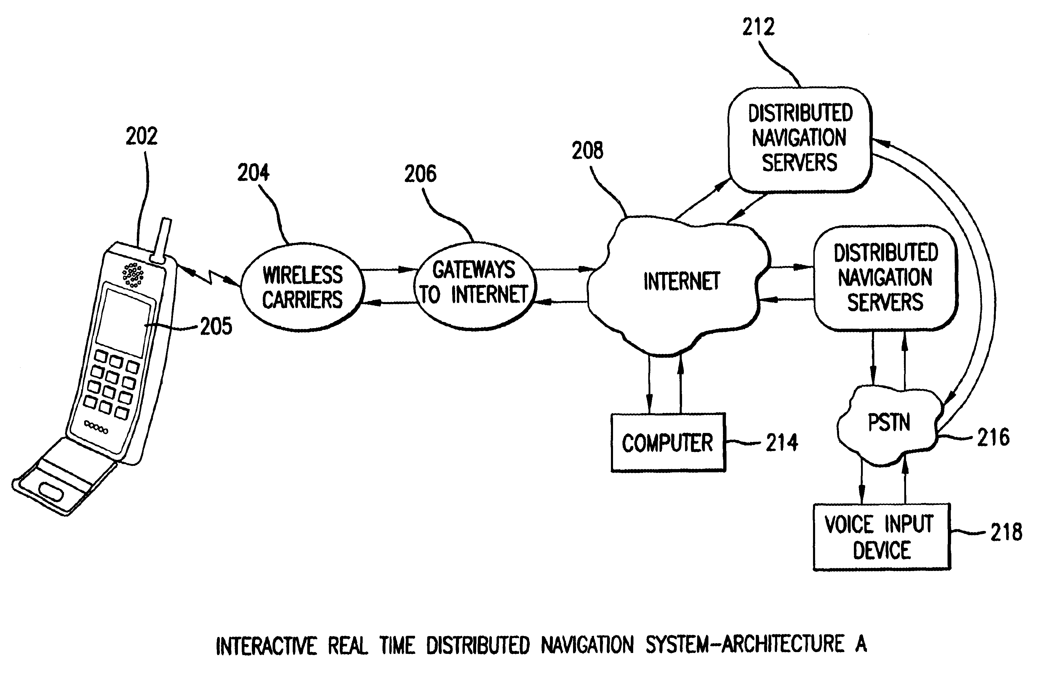
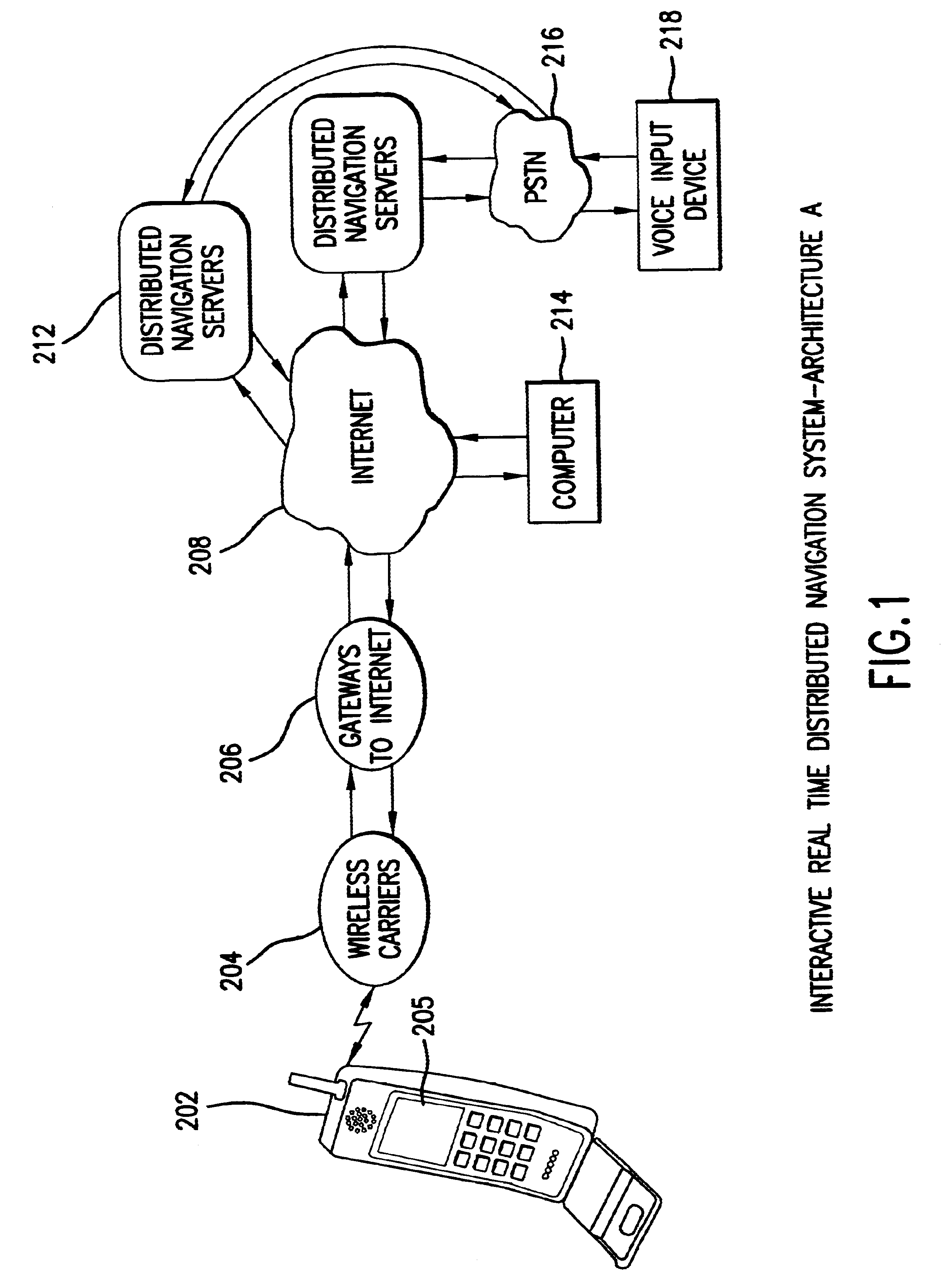
FIG. 1 shows an architecture for an interactive real-time distributed navigation system in accordance with a preferred embodiment. The various components and their interaction will now be described. It is to be understood that where like numerals are used in different figures, such like numerals refer to the same item. Wireless device 202 may take the form of a cellular telephone, satellite telephone, wireless Personal Digital Assistant (PDA), personal computer or other suitable device having wireless communications capability. Preferably, wireless device 202 is equipped with positioning capability that takes the form of, for example, global positioning systems (GPS), emergency 911 (E911) location, or others, including those that may become available in the future. Currently, various manufacturers produce wireless telephones, which are enabled with the Wireless Application Protocol to present information to the user. Manufacturers include AT&T, SPRINT PCS, GTE WIRELESS. In a specifi...


PUM


Abstract

An enhanced operating environment for an Interactive Real-Time Distributed Navigation system is disclosed. In the present invention, an enhanced operating environment is provided by improving input and output techniques in a navigation system. Disclosed are methods for reducing the number of inputs to a navigational sytstem through a wireless device. Improved input methods include methods for entering non-deterministic information to retrieve deterministic information. Also disclosed are improved output techniques including methods for pacing navigational prompts provided by a navigation system. The invention is applicable to text, graphics or audible navigation systems.

Description

I. FIELD OF THE INVENTIONThis invention relates to navigation systems and location-based information delivery. Specifically, this invention relates to a method and system for an efficient operating environment for interactive and real-time navigation.II. BACKGROUND OF THE INVENTIONMany commercial navigation systems are based on satellite-based global positioning system (GPS) devices, which have been applied in automobile navigation, see, e.g., U.S. Pat. Nos. 5,938,720; 5,928,307; 5,922,042; 5,912,635; 5,910,177; 5,904,728; 5,902,350, all incorporated herein by reference for all purposes. Such automobile navigation systems, however, are expensive and inconvenient to use. Further, many such systems are not appropriate for navigation while the user is walking. Therefore, there is a need in the art to incorporate navigation systems in personal handheld devices.There are several technical obstacles that stand in the way of the incorporation of navigational capabilities in handheld device...

Claims


Application Information

Patent Timeline
IPC IPC(8): G01C21/26G08G1/0968G06F17/30G08G1/005H04L29/08H04L29/06H04L12/56G01S19/48
CPCG01C21/26G08G1/005G08G1/096811G08G1/096816G08G1/096838G08G1/096872G08G1/096883G08G1/096888H04L29/06H04L67/04H04L67/18H04L69/329H04L63/083H04W64/00H04L67/52H04L9/40
Inventor RENNARD, ROBERTDU, SEAN QUANNASSER, SAMI FAWZICHAO, YI-CHUNGMESHENBERG, RUSLAN ADIKOVICHJIN, HAIPINGYIP, CHUNG BENJAMIN
Owner TELENAV
Learn More