Method and apparatus for ultra precise GPS-based mapping of seeds or vegetation during planting

a mapping and gps technology, applied in the field of precision farming methods, can solve the problems of system use of very low ground speed and limited success of precision techniques, and achieve the effects of reducing production costs, ensuring safety, and controlling seed application

Inactive Publication Date: 2005-09-06
RGT UNIV OF CALIFORNIA
View PDF25 Cites 95 Cited by
  • Summary
  • Abstract
  • Description
  • Claims
  • Application Information

AI Technical Summary

Benefits of technology

[0014]In accordance with another embodiment of the invention, the sensors are omitted. Instead of sensing seeds falling through the seed tubes, the invention controls the seed dispensing operation. In this embodiment of the invention, RTK GPS is used to determine when the seed dispenser is above the desired planting location. When the desired location has been reached, the invention activates the seed dispenser to drop the seed. This can be accomplished by, for example, cutting off the vacuum on a vacuum metering plate commonly used in vacuum planters. By dropping the seeds at the desired location in this manner, check row planting is made possible. The planting map generated in this embodiment is essentially the same as before, except that the invention determines the locations for seeds rather than senses the locations for the seeds.
[0015]Once the planting map is generated, the map can then be used for a variety of purposes such as applying pesticides directly to the plants, cultivating, plant thinning, and other field operations. In addition, by further employing a greenness sensor to detect green plants and identify those plants (e.g., weeds) which are not a part of the original seed / plant map, chemical or non-chemical (such as biological) herbicides can be selectively applied to control weeds. Additionally, mechanical cultivation, pulsed electrical shock, and flame weeding is also made possible on an automated basis. Vegetative mass where plants are not expected on the plant map can be cultivated or otherwise destroyed. Further, seed application can be controlled during planting.
[0016]Thus, it can be seen that accuracy in seed placement makes it possible to develop an accurate seed map that can be used to target chemical application and / or mechanical cultivation thus reducing the cost of production and protecting the environment. Moreover, such seed maps can assist in autonomous vehicle guidance, which can reduce operator fatigue as well as improve machinery performance by reducing overlap during field operations such as tillage, chemical application, etc.
[0019]Another object of the invention is to provide a system that reduces the amount of fertilizers and pesticides and the like that is applied to a field by permitting plant and location specific applications.

Problems solved by technology

Such precision techniques have had limited success because they are often man-power intensive to assure accuracy.
However, since optical discrimination between plants and weeds using image analysis to extract relevant features is computationally intensive, these systems must employ very low ground speed.

Method used


Image

  • Method and apparatus for ultra precise GPS-based mapping of seeds or vegetation during planting
  • Method and apparatus for ultra precise GPS-based mapping of seeds or vegetation during planting
  • Method and apparatus for ultra precise GPS-based mapping of seeds or vegetation during planting

Examples


example 1

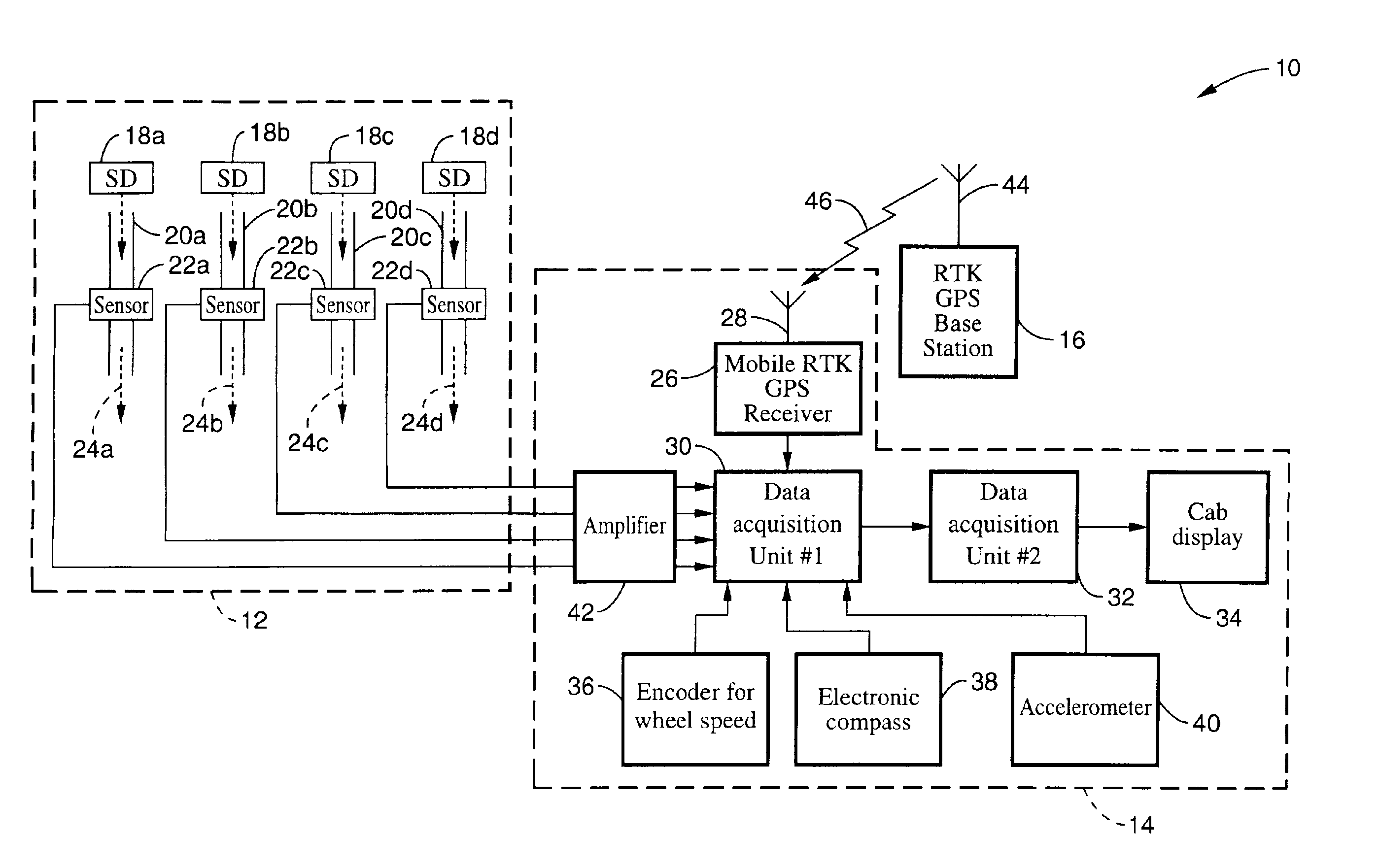
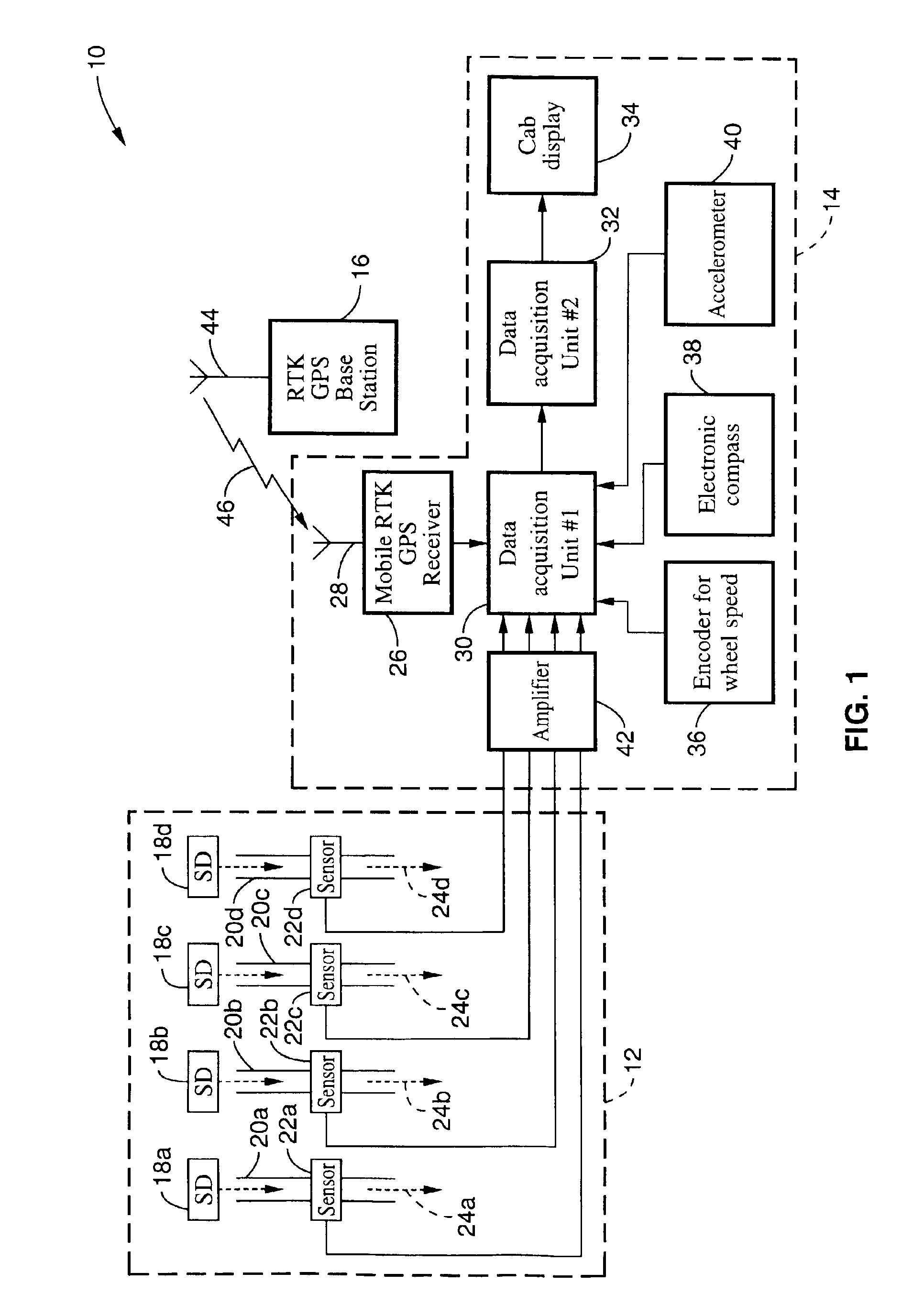
[0061]A four row Salvo 650 vacuum planter was retrofitted with a complete set of 4700 series centimeter accuracy surveying and mapping system comprising a base unit, a rover, radio link, and other accessories provided by Trimble Navigation Ltd. Two single board data loggers were used to acquire data in real-time and display it in the tractor cab. The first data logger was interfaced to the centimeter accuracy GPS unit, the optical sensors, an encoder, and an accelerometer. The second data logger was interfaced to a display unit mounted in the cab. The two data loggers and the GPS receiver were mounted in a rugged, weatherproof metal box and secured to the planter frame. The accelerometer and GPS antenna were installed on the top of the toolbar frame. The GPS antenna was directly ahead of planter unit #1. The accelerometer was included to monitor the planter dynamics since it was thought to be a critical issue in determining seed dynamics; however, the information was found not to be...

example 2

[0062]Preliminary tests indicated that all of the sensors and the GPS unit were working. Following the preliminary tests, field tests were conducted over two planting seasons to check the performance of the plant mapping system. In the first year, four rows were planted during each pass through a 165-ft. test plot. Corn seed (hybrid: Pioneer 3162 R24) was planted at a depth of two inches and an operating speed of 2 mph. In each row, 15-ft sections were marked consecutively. Three of the eleven 15-ft sections were selected at random for analysis. The sections were measured by the Trimble RTK surveying equipment. The distance between the plants was also measured with a tape measure in order to check the accuracy of the Trimble surveying equipment. A computer program was written to process the seed and GPS location data and estimate the exact coordinates of each seed and its distance from the adjacent seed. When we examined the RTK GPS position, we found that they did not all lie on a ...

example 3

[0063]We learned that RTK GPS quality was very important. As long as RTK GPS quality was “3” we were guaranteed centimeter accuracy. We developed an algorithm that utilized only quality “3” GPS signals and continuously performed instantaneous ground wheel calibration which could be used for prediction purposes if a quality “3” GPS signal was unavailable. The interpolation technique provides the antenna location in UTM coordinates. To obtain the exact location of the seeds it was necessary to implement an Eluerian rotation scheme.

[0064]This modified scheme was tested during the second year of this study. Some of the early plantings indicated that we were not receiving quality “3” signal most of the time. It turned out that the base station antenna was not high enough. In response, we constructed a tall tower (about 12-ft. tall) to mount the antenna near the base station. Elevating the antenna at the base station virtually eliminated problems with RTK GPS signal quality.

[0065]The sens...


PUM


Abstract

An ultra precise seed planter apparatus and method for generating a centimeter accuracy map of the location of seeds or vegetation as they are planted from an agricultural planting machine. The apparatus is fitted with a GPS receiver feeding a data logger, and optical sensors that are placed adjacent seed or vegetation dispenser. The data logger monitors GPS time and UTM coordinates, as well as the optical sensors. Ground speed and azimuth are also monitored. The seeds or vegetation are time-tagged as they are dispensed, and software is used to process the dispensing time and GPS location data and estimate the exact coordinates of each seed or plant and its distance from adjacent seeds or plants. As a result, a precise planting map is generated. The invention may also be used to determine the location to dispense seeds or vegetation, and activating the dispenser when that location is reached.

Description

CROSS-REFERENCE TO RELATED APPLICATIONS[0001]This application is a continuation of application Ser. No. 09 / 895,853 filed on Jun. 29, 2001, now U.S. Pat. No. 6,516,271, incorporated herein by reference, and a divisional of application Ser. No. 09 / 895,851 filed on Jun. 29, 2001, now U.S. Pat. No. 6,553,312, incorporated herein by reference.STATEMENT REGARDING FEDERALLY SPONSORED RESEARCH OR DEVELOPMENT[0002]Not ApplicableREFERENCE TO A COMPUTER PROGRAM APPENDIX[0003]Appendix A “Data Acquisition Program” and Appendix B “Seed Mapping Program” referenced herein are contained in the enclosed compact disc in a file entitled “UC00-174-2.txt” created on Feb. 3, 2003 and having a 24 kb file size. The computer program code, which exceeds 300 lines, is submitted on compact disc in accordance with 37 CFR 1.52. Two compact discs are provided according to 37 CFR 1.52(e)(4). Appendix A and Appendix B contained on the compact disc are incorporated by reference herein.BACKGROUND OF THE INVENTION[0004...

Claims


Application Information

Patent Timeline
Patent Type & Authority Patents(United States)
IPC IPC(8): A01B79/00A01C7/10A01C7/08G01S13/00G01S13/60G01S5/14G01S19/48
CPCA01B79/005A01C7/105A01C21/005G01S19/14G01S19/44G01S13/60
Inventor UPADHYAYA, SHRINIEHSANI, MOHAMMADMATTSON, MARK L.
Owner RGT UNIV OF CALIFORNIA
Why Eureka
Try Eureka