
Synthetic-aperture radar system and operating method for monitoring ground and structure displacements suitable for emergency conditions

a radar system and synthetic aperture technology, applied in the direction of radio wave reradiation/reflection, using reradiation, measurement devices, etc., can solve the problems of tens of minutes, minimum time, and main difficulties found during installation operations, and achieve the effect of improving performan

Active Publication Date: 2013-02-26
ELLEGI
View PDF10 Cites 26 Cited by
  • Summary
  • Abstract
  • Description
  • Claims
  • Application Information

AI Technical Summary

Benefits of technology

[0045]The aim of the present invention is to provide a synthetic aperture radar system and an operating procedure for the monitoring of ground and structure displacements, which is particularly suitable for emergency conditions, and have improved performances in relation to existing ground based radar sensors.

Problems solved by technology

However, in locating a suitable position for the system installation, the main difficulties are found during the installation operations.
Thus, a main disadvantage of these systems is that the minimum time for obtaining two individual images and for processing the related data to achieve an interferogram representing the displacements of the objects belonging to the observed scenario is of the order of tens of minutes.
Therefore, quickly moving objects in the observed scenario such as cars, volcanic lava effusions, harbored ships, sea waves, fast landslips and debris flow and so on, cannot be monitored since this kind of radar systems can only supply indications on the displacements of objects moving just a few millimeters in a time period required to acquire the data needed for a single image creation.
1. A very low measurement speed;
2. The systems cannot be easily installed and does not have a suitable operating autonomy;
3. A great difficulty in fitting the system hardware to specific requirements of the phenomena to be monitored;
4. It is very difficult to transport the system to or through scarcely accessible and impassable regions;
5. It is not possible to real time supply data, information and alarms;
6. It is not possible to real time and remotely control and send information without an external PC permanently connected to the system;
7. It is very difficult to provide systems which, upon many mechanical component disassembling, reassembling and mechanical parts replacing operations are still suitable to provide measurements consistent with those acquired before these operations;
8. It is not possible to provide consistent results by a coordinate system different from the intrinsic coordinate frame of the radar system, this latter limitation reduces greatly the system efficiency with respect to other sensing systems, if it is required or desired to compare results with those of other different monitoring systems and it is therefore required a georeferencing of the system results to geographic coordinate systems different from its intrinsic coordinate frame.

Method used


Image

  • Synthetic-aperture radar system and operating method for monitoring ground and structure displacements suitable for emergency conditions
  • Synthetic-aperture radar system and operating method for monitoring ground and structure displacements suitable for emergency conditions
  • Synthetic-aperture radar system and operating method for monitoring ground and structure displacements suitable for emergency conditions

Examples


Embodiment Construction

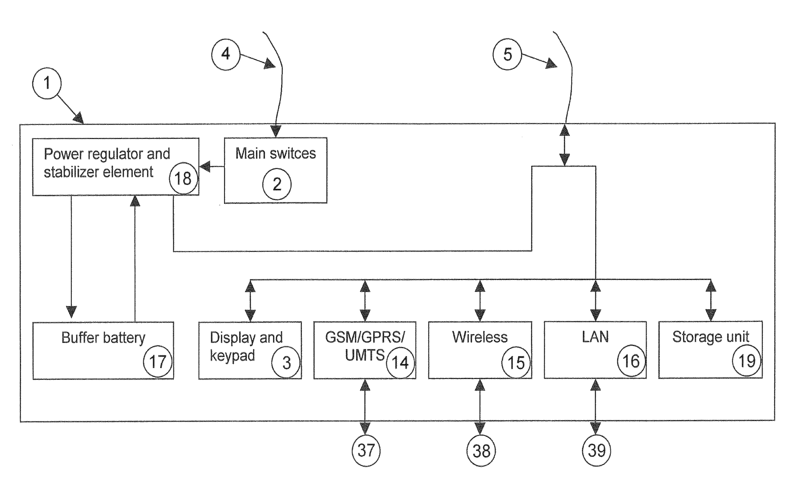
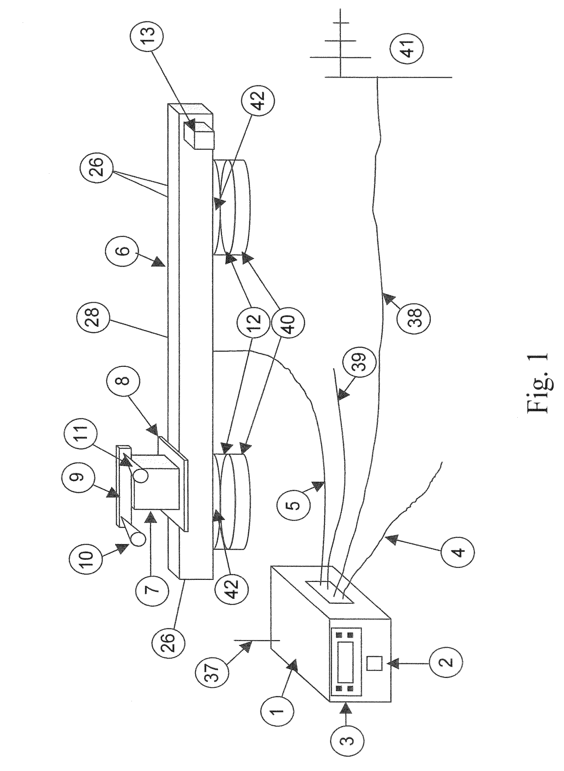
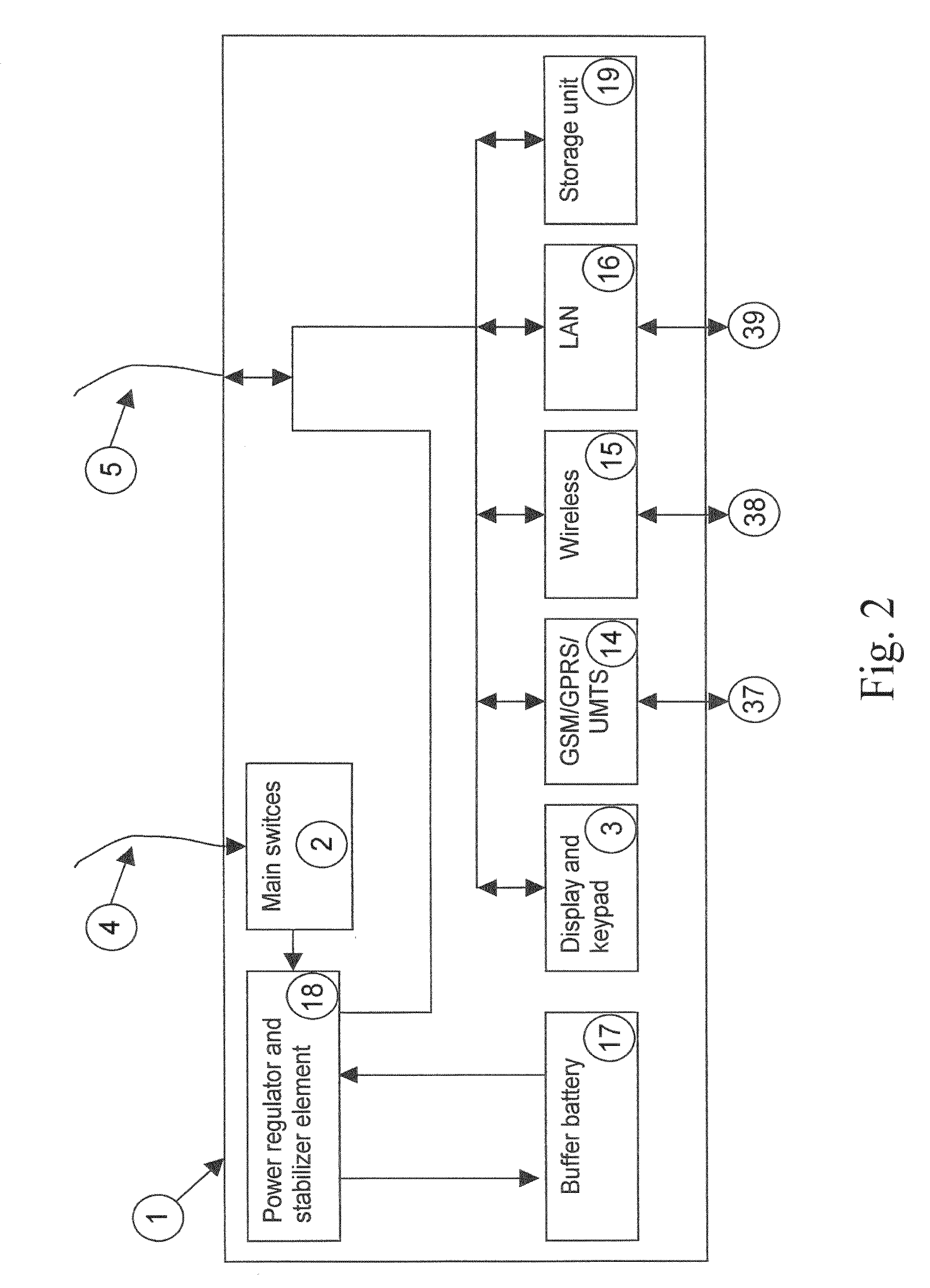
[0097]In the figures, number references have the following meaning:[0098]1. Power supply and connection unit[0099]2. Main switch[0100]3. Alphanumeric display with keypad[0101]4. Power cable (Power line—Unit 1)[0102]5. Umbilical cable[0103]6. Linear Positioner[0104]7. Measuring head[0105]8. Reference counter-plate[0106]9. Mechanical module (for the orientation of the antennas)[0107]10. Transmitting antenna[0108]11. Receiving antenna[0109]12. Linear positioner fixing plate[0110]13. Electric motor, geared unit and encoder[0111]14. GSM / GPRS / UMTS transmission and receiver module[0112]15. WLAN module[0113]16. LAN module[0114]17. Buffer battery[0115]18. Regulator and stabilizer element[0116]19. Storage unit[0117]20. Electromagnetic signal generator and receiver unit[0118]21. Main system control unit[0119]22. GPS module[0120]23. Digital videocamera / photocamera[0121]24. Motor control unit[0122]25. I / O module[0123]26. Zero and runout sensors[0124]27. Microwave coupler[0125]28. Junction box[01...


PUM


Abstract

A synthetic-aperture radar system, and related operating method, for the monitoring of ground and structure movements, particularly suitable for emergency conditions, characterized by a ground based platform with polarimetric capabilities, that able to quickly acquire, embeddedly process and post-process data by a novel data acquisition “On the Fly” mode of operation, reducing by at least an order of magnitude the data acquisition time. The inventive system characteristics allows to achieve on-field measurement results on three-dimensional maps georeferenced to absolute coordinate systems (WGS84, Gauss-Boaga, and so on). The operating method includes the step of installing the system, the acquiring of the first measurements, the quick data processing and post-processing to provide sub-millimetric precision georeferenced bi-dimensional and three-dimensional displacement maps for the objects belonging to the monitored scenario, with an improved performance and in a measurement time compatible to that required in an emergency condition, with an higher degree of integration with other sensors and autonomously and embeddendly.

Description

BACKGROUND OF THE INVENTION[0001]The present invention relates to a synthetic-aperture radar system and a connected operating method for monitoring ground and structure displacements, particularly suitable for emergency conditions.[0002]More specifically, the invention relates to a novel synthetic aperture radar sensor with a ground based platform and having interferometric and polarimetric capabilities as to be easily used on field for acquiring and processing in short time data and for immediately using and displaying the processing results.[0003]This sensor is suitable for monitoring hydrogeological instabilities such as landslides, landslips, avalanches, volcanoes and so on, settlings and yieldings of antropic structures such as dams, bridges, buildings and so on, but it is especially suitable for emergency conditions.[0004]In such conditions, the radar system installation and setting up, the beginning of the measurements and the achievement of early results must be accomplished...

Claims


Application Information

Patent Timeline
Patent Type & Authority Patents(United States)
IPC IPC(8): G01S13/90
CPCG01S13/9023G01S7/024G01S7/497
Inventor LEVA, DAVIDERIVOLTA, CARLO
Owner ELLEGI
Learn More