Electro-optic system for crosswind measurement

a technology of optical system and crosswind measurement, which is applied in the direction of distance measurement, optical radiation measurement, radiation controlled devices, etc., can solve the problems of inability to conduct these functions, insufficient advancement, and difficulty in keeping on targ

Inactive Publication Date: 2015-09-08
UNITED STATES OF AMERICA AS REPRESENTED BY DEFENSE ADVANCED RES PROJECTS AGENCY +1
View PDF16 Cites 32 Cited by
  • Summary
  • Abstract
  • Description
  • Claims
  • Application Information

AI Technical Summary

Benefits of technology

[0013]The optical transmitter may be configured to produce a collimated beam that may create a small light spot on the target. Also, the optical receiver may be configured to include first and second wind measurement channels separated from one another in a horizontal direction or in a vertical direction by a predetermined distance to measure the horizontal or vertical component of the crosswind. These first and second wind measurement channels may be used for detecting light reflected from the target which travels back toward the system through atmospheric turbulence eddies which move with crosswinds. Particularly, an image sensor may detect such light via said first and second wind measurement channels, respectively, at a measurable time difference. Since this time difference is dependent on the downrange crosswind speeds (as well as the predetermined distance separating the first and second wind measurement channels), the system is able to determine a path-weighted average crosswind in the horizontal direction by the measurement of transit time difference.

Problems solved by technology

Two dominant sources of hit point errors are the uncertainty in the estimation of the magnitude and direction of path integrated crosswind and the range to target.
During the day, an experienced user can estimate the crosswinds by viewing the mirage through the riflescope or the vegetation motion and the range to target by comparing the target size to the crosshair reticle but is unable to conduct these functions during the night or in twilight.
Even these advancements are inadequate.
The anemometers just measure the local winds, while handheld range finders are difficult to keep on target, providing inaccurate results.
These changes can be due to causes such as non-uniform terrain channeling and environmental pressure or temperature differential changes.
Because the local wind sensor cannot measure downrange winds, it provides an offset that would lead to a target miss.
Experienced users know that this assumption is inaccurate because the projectile in flight integrates the winds as it flies along its trajectory to the target.
The LIDAR method cannot easily measure projectile path crosswinds unless measurements are made in three known off-axial directions and the path-average crosswind calculated from the vector addition.
In addition the system requires impractical laser powers to achieve high accuracy at even modest ranges because the back-scattered signal modulated from aerosols in the atmosphere is approximately 6 orders of magnitude smaller than a modulated signal scattered from a solid target surface.
This imposes stringent demands on required laser power, laser current drivers, power supply and signal processing, making the system size too big for practical mounting on the weapon.
It is therefore a point measurement, and does not provide path-integrated wind from the shooter to the target.
Because the opportunity to engage and hit the target is time sensitive, all measurements must be done in near real time to calculate and display the offset aim point (OAP) in the user's sight; otherwise the opportunity may be permanently lost.
This approach suffers from several drawbacks, including: 1) the effect of the return path turbulence on the signal scattered from the target acts as a noise source reducing the overall signal to noise ratio; 2) because the ability to resolve the light and dark spots on the target is limited by diffraction of the collecting lens aperture, large lens apertures (in excess of 100 mm) are required thus increasing the size of the system; 3) higher laser signal power is required because the returned signal spreads over many pixels due to aperture diffraction requiring higher optical power per pixel to measure the crosswind, thus significantly affecting battery life; 4) the approach is sensitive to scintillation index, which reduces the size of the dark and light spots at higher indices exceeding 10−13, requiring even higher optical resolution (i.e., an aperture larger than 100 mm and more optical power).
Uniform targets without features or that blend into the background (camouflaged) cannot be resolved easily.
The size of two such lenses makes the device impractical for mounting on a weapon.
For the hunting application, the one-way transmission system is clearly impractical because the laser and optical receivers must both be on the same side (user's end) of the path.
When adapting this one-way transmission system to a two-way reflective system, one of the key problems encountered is the laser speckle noise generated from the illuminated target.
Laser speckle is an interference effect that creates non-uniform distribution of the light intensity (light and dark spots) when laser light reflects back from a target surface that has a surface roughness smaller than the coherence length of the laser.
As a result the covariance function is disturbed by the interference from speckle effects causing large errors in the wind measurement.
This limits the size of the receiver lens that can be used.
Large transmitter and receiver apertures impose size constraints in designing a weapon mounted or portable compact system package.
These constraints impose yet more challenges in the innovation of a small and portable system useful for operation on or off a weapon.

Method used


Image

  • Electro-optic system for crosswind measurement
  • Electro-optic system for crosswind measurement
  • Electro-optic system for crosswind measurement

Examples


Embodiment Construction

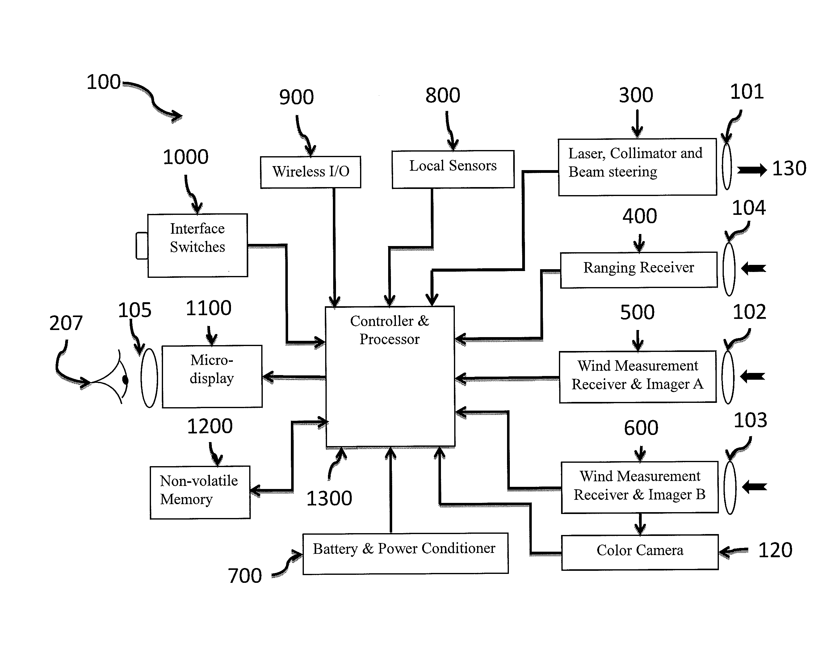
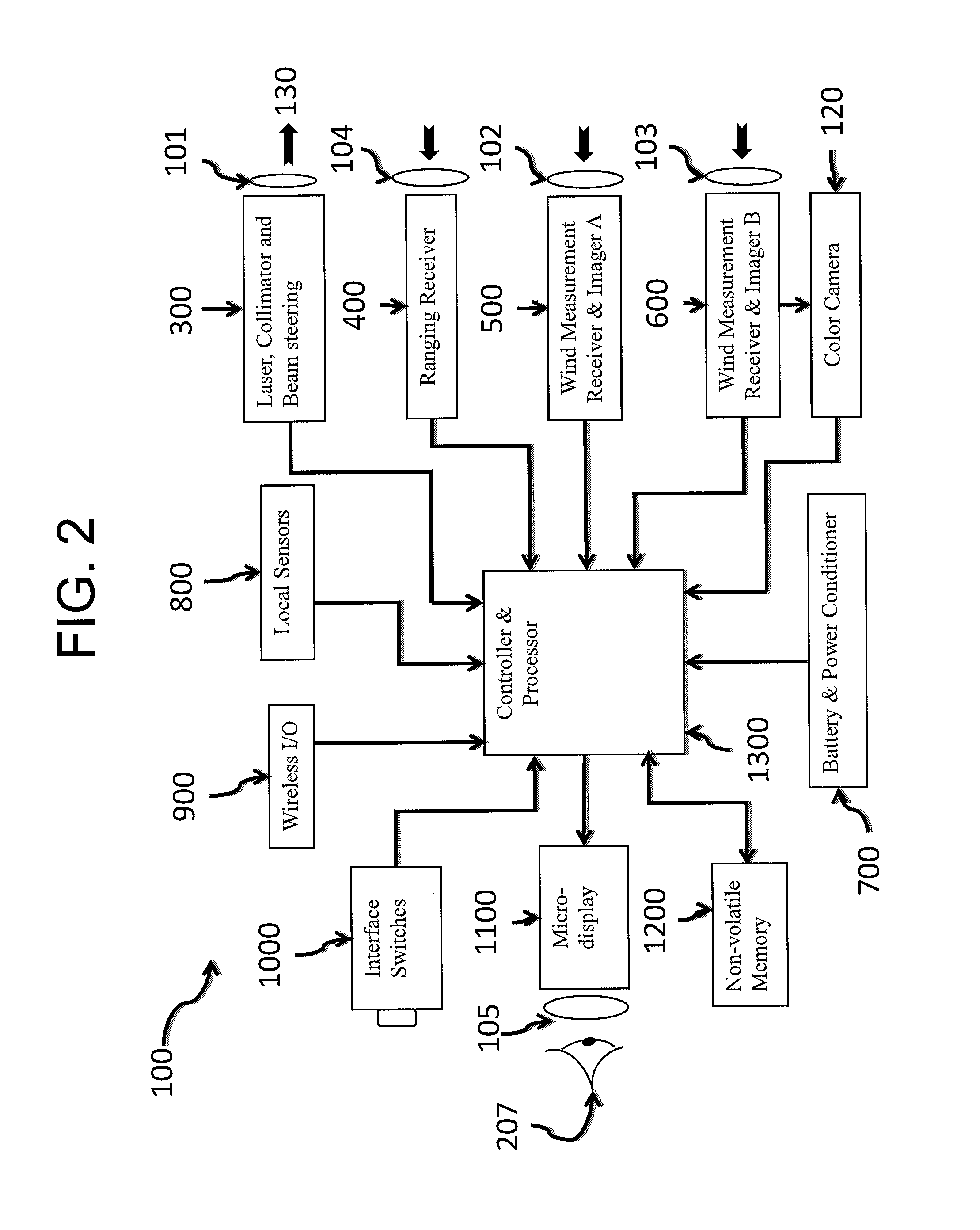
[0035]An exemplary embodiment of a system, which is referred to hereinafter as the “XeroWind System” (or “XWS” for short), is designed for use as a replacement to the riflescope to not only measure the crosswind and range but also to provide an image of the target for acquisition and aiming. According to one alternate embodiment, however, the XWS may be configured as a clip-on so that the users may retain their direct-view riflescopes if desired. In another alternate embodiment, the XWS may be used as a standalone system mounted to a tripod for assisting a spotter. The system can measure the path-weighted average crosswind between the user and the target, the range to the target, and then, using the ammunition characteristics (mass, size, shape, muzzle velocity), atmospheric data and weapon angles, and other data, it calculates the azimuth and elevation offset aim points (OAP) to compensate for the wind deflection and ballistic drop of the ammunition used. The calculated offsets and...


PUM


Abstract

An electro-optic system, e.g., mounted to a weapon, measures down range winds and a range-to-target for compensating the ballistic hit point. The system may include an optical light source, collimated to generate a laser spot on the target. The system may include a wind measurement receiver that captures laser light scattered from the target. The captured light may be modulated by atmospheric scintillation eddies, producing optical patterns which change in time and move with the crosswind. These patterns may be analyzed by a processor using covariance techniques to determine path-integrated crosswinds and associated errors. Ranging is done by measuring the time of flight of the laser pulse to the target collecting the scattered signal from the target. Compensated ballistic hit point, measurement errors and other data may be displayed on a micro-display digital eyepiece, overlaid on the real-time image of the target.

Description

FIELD OF THE INVENTION[0001]The present invention is directed to a system and method for measuring downrange path integrated winds and a range-to-target for purposes of compensating a ballistic hit point.BACKGROUND OF THE INVENTION[0002]Deer hunting sport has been practiced for many centuries. Better materials, better weapon designs and ammunitions allow hunters to engage targets at longer ranges and with more precision than was possible in the past. Typical rifles such as Remington® model 243 allow engagements to ranges greater than 400 meters. However, it has been recognized that there are a number of factors that affect the position of the projectile hit point. Two dominant sources of hit point errors are the uncertainty in the estimation of the magnitude and direction of path integrated crosswind and the range to target. The effect of these errors on the hit point grows substantially as the standoff range between the hunter and the target increases and / or the crosswind increases...

Claims


Application Information

Patent Timeline
Patent Type & Authority Patents(United States)
IPC IPC(8): G06F19/00G01P5/26F41G3/08H01L27/146G06G7/80G01W1/00G01J1/42G01C3/00F41G1/00
CPCF41G3/08F41G1/00G01C3/00G01J1/4257G01P5/26G01W1/00H01L27/14643F41G1/36G01S17/95F41G3/06Y02A90/10
Inventor VARSHNEYA, DEEPAKGRIGGS, STEVEJEFFERS, LARRY
Owner UNITED STATES OF AMERICA AS REPRESENTED BY DEFENSE ADVANCED RES PROJECTS AGENCY
Why Eureka
Try Eureka