A Navigation System for Offshore Streamer Seismic Exploration

A seismic exploration and navigation system technology, which is applied in navigation, surveying and mapping, navigation, surveying devices, etc., can solve the problems of restricting the application of new technologies in exploration operations, lack of international language package support, and inability to operate across platforms, so as to achieve rich and mutual The effect of less intervention and simple structure

Active Publication Date: 2017-11-03
CHINA NAT OFFSHORE OIL CORP +1
View PDF3 Cites 0 Cited by
  • Summary
  • Abstract
  • Description
  • Claims
  • Application Information

AI Technical Summary

Problems solved by technology

[0003] At present, the navigation systems used in offshore oil exploration are all dependent on imports, such as spectrum, orca, etc. These navigation systems are based on traditional software development technology, cannot run across platforms, have no international language package support, complex protocols, and complex operations. Poor maintainability restricts the application of new technologies in exploration operations

Method used


Image

  • A Navigation System for Offshore Streamer Seismic Exploration
  • A Navigation System for Offshore Streamer Seismic Exploration
  • A Navigation System for Offshore Streamer Seismic Exploration

Examples


Embodiment approach 1

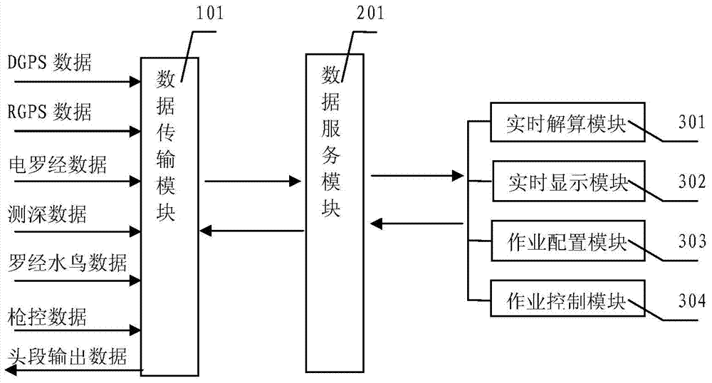
[0048] like figure 1 As shown, a navigation system 1 for marine streamer seismic exploration of the present invention includes a data transmission module 101, a data service module 201, a real-time calculation module 301, a real-time display module 302, a job configuration module 303 and a job control module 304 ; the data transmission module 101 is electrically connected to the data service module 201 , and the data service module 201 is also electrically connected to the real-time calculation module 301 , the real-time display module 302 , the job configuration module 303 and the job control module 304 . That is to say, mutual transmission of data is realized through the above electrical connections. In addition, the electrical connection here may be a wired electrical connection through cables, or a radio connection through wireless transmission.

[0049]The data transmission module 101 is used to collect external data, and send the collected external data to the data serv...

Embodiment approach 2

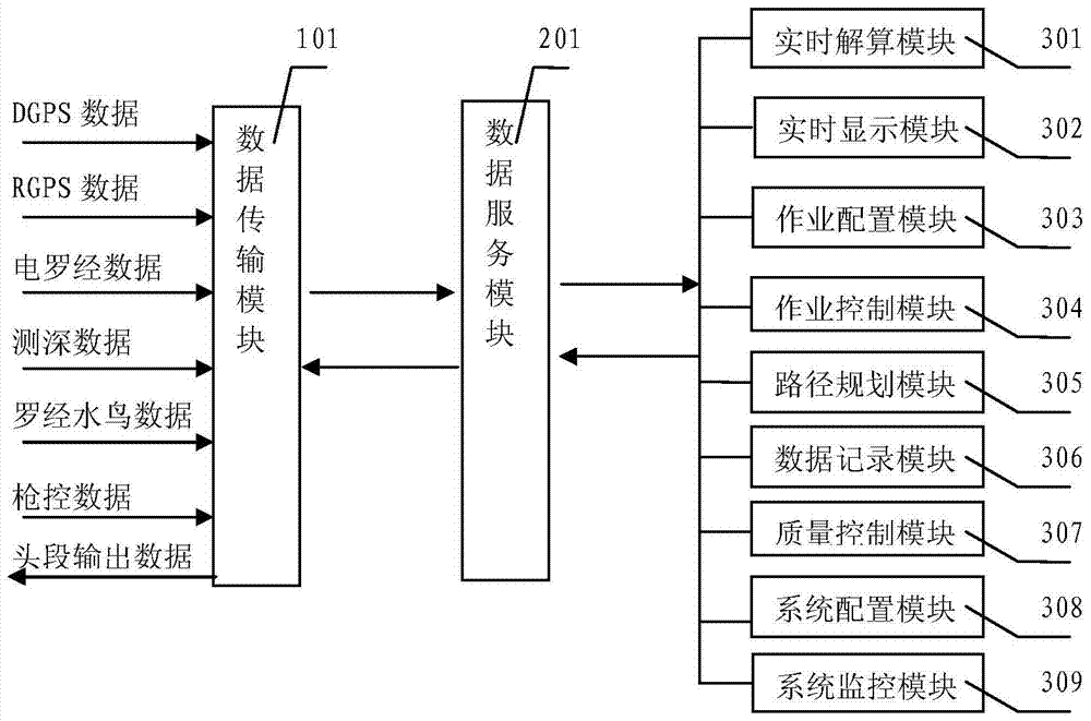
[0077] Compared with Embodiment 1, the difference is that it also includes the following modules, such as figure 2 Shown: path planning module 305 , data recording module 306 and quality control module 307 , and system configuration module 308 and system monitoring module 309 .

[0078] The path planning module 305 is electrically connected to the data service module 201, and the path planning module 305 is used to perform path planning on the navigation path and the obstacle detour route, and send the planned path planning data to the data service module 201 for storage, and then by The data service module 201 sends to the data transmission module 101 . For example, the route planning module can perform route planning on the ship's turning route, obstacle detour route, etc., provide a navigation plan, and send configuration information to the data service module 201 for storage.

[0079] The data recording module 306 is electrically connected with the data service module 20...


PUM


Abstract

The invention relates to the technical field of sea exploration and particularly relates to a navigation system for offshore towing rope seismic exploration. The navigation system for the offshore towing rope seismic exploration comprises a data transmission module, a data service module, a real-time resolving module, an operation configuration module, an operation control module and a real-time display module, wherein the data transmission module is electrically connected with the data service module; the data service module is also respectively and electrically connected with the real-time resolving module, the operation configuration module, the operation control module and the real-time display module. According to the invention, the modular design is simultaneously adopted; each module meets the requirements on high cohesion and low coupling; the navigation system has high module integration, low interference among the modules, a simple structure, definite functions, good maintainability and high synchronism efficiency; moreover, the service / client mode design is adopted, the data service module is used as a server, other modules are used as software clients and the server is connected with the clients by the Ethernet, so that the system can be arranged in one or more servers.

Description

technical field [0001] The invention relates to the technical field of marine exploration, in particular to a navigation system for seismic exploration of sea streamers. Background technique [0002] In marine seismic exploration, the integrated navigation system is the control and command center in marine seismic exploration operations, providing coordinate positioning for the exploration ship, guiding the direction of the exploration ship, and controlling the cooperative work of the seismic data acquisition system, source system, tow cable positioning and control system , and real-time calculation of source and receiver locations, analysis of reflection panel coverage, and effective control of the quality of seismic exploration operations. The integrated navigation system plays an important role in the construction efficiency and acquisition accuracy of marine seismic operations. [0003] At present, the navigation systems used in offshore oil exploration are all dependen...

Claims


Application Information

Patent Timeline
Patent Type & Authority Patents(China)
IPC IPC(8): G01C21/00
CPCG01C21/203
Inventor 阮福明王斌曹占全吴秋云朱耀强董伟良吴超胡广浩曾翔李柳胜
Owner CHINA NAT OFFSHORE OIL CORP
Why Eureka
Try Eureka