Three-dimensional radar altitude dynamic calibration device and method based on unmanned helicopter with rotor wings

A rotor unmanned, dynamic calibration technology, applied in radio wave measurement systems, measurement devices, instruments, etc., can solve the problems of low accuracy of true value positioning equipment, failure to meet accuracy requirements, and potential safety hazards, and achieve novel design ideas. , the calibration method is scientific, the effect of strong on-site operability

Inactive Publication Date: 2014-07-02
PLA DALIAN NAVAL ACADEMY
View PDF4 Cites 16 Cited by
  • Summary
  • Abstract
  • Description
  • Claims
  • Application Information

AI Technical Summary

Problems solved by technology

However, using a balloon as a calibration target requires an air traffic control application. After the balloon is released, it is generally impossible to recover, and there are also potential safety hazards.
The disadvantage of using civil aviation aircraft is that the target is a non-cooperative target, and it is easy to register the wrong number. Due to the uncontrollable route, the amount of data will be very small. to the accuracy requirement

Method used


Image

  • Three-dimensional radar altitude dynamic calibration device and method based on unmanned helicopter with rotor wings
  • Three-dimensional radar altitude dynamic calibration device and method based on unmanned helicopter with rotor wings
  • Three-dimensional radar altitude dynamic calibration device and method based on unmanned helicopter with rotor wings

Examples


Embodiment Construction

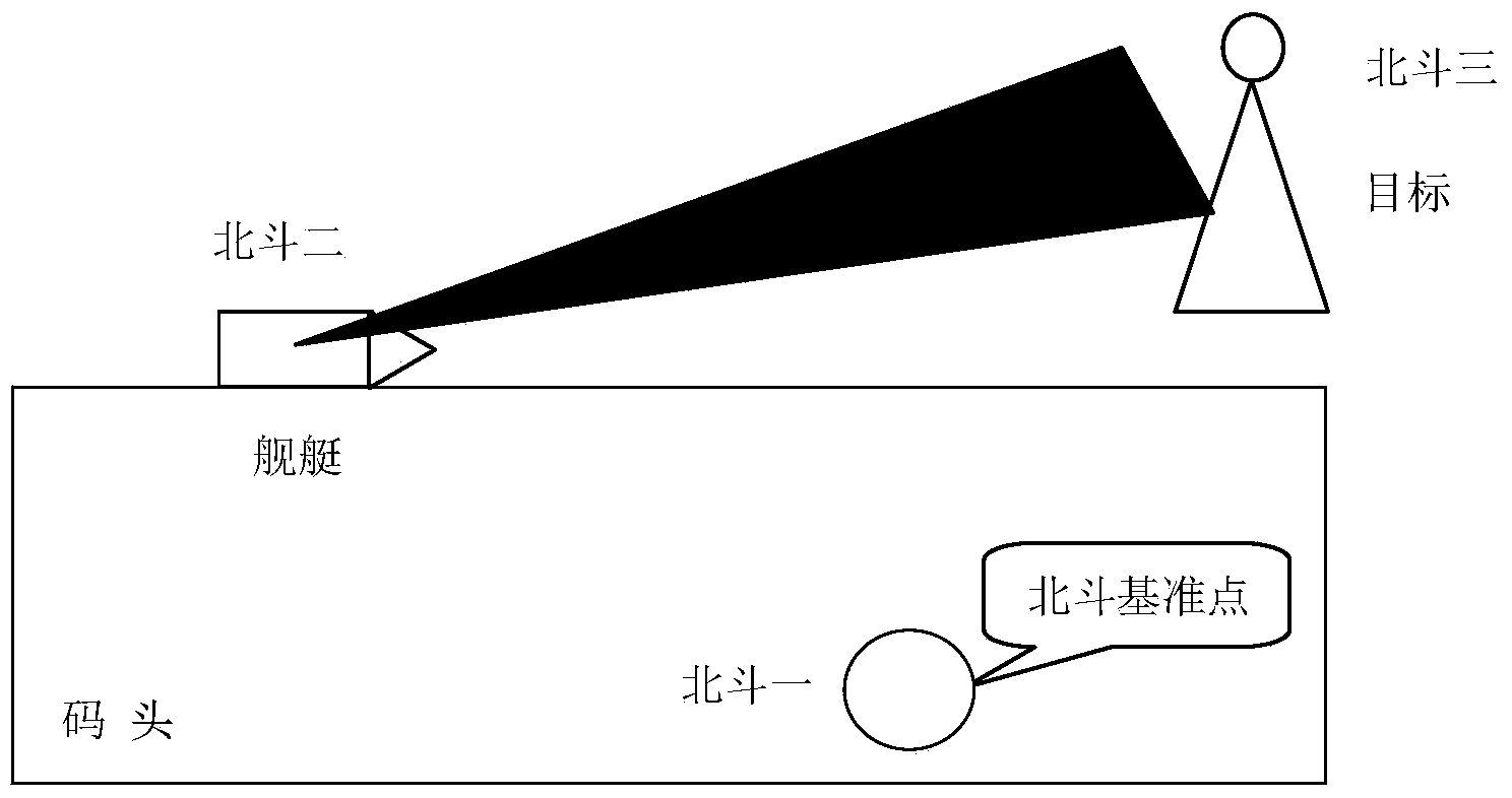
[0023] According to the technical standards for ship radar equipment repair, when the radar measurement accuracy is calibrated, the accuracy of the real height data equipment is required to be at least three times the radar measurement accuracy. Taking the typical value of three-coordinate radar accuracy as an example: the elevation angle accuracy is less than 0.5°, and the distance accuracy is less than 100m. It can be seen that if the accuracy of the real height data of the elevation angle is within 0.1°, and the accuracy of the real height data of the distance is within 25m, the requirement can be met.

[0024] Simulation of elevation angle measurement accuracy by Beidou positioning system Figure 4 It can be seen that when the distance between the radar and the target is 284.3687m, the measurement accuracy of the elevation angle is 0.1007°. That is, as long as the distance between the radar and the target exceeds 300m, the ranging accuracy of the Beidou positioning system...


PUM


Abstract

The invention belongs to a radar calibration device, and relates to a three-dimensional radar altitude dynamic calibration device and method based on an unmanned helicopter with rotor wings. The radar altitude dynamic calibration device comprises three big dipper receiver terminals, a warship-mounted radar data recording device, a flying control system and a calculating sub-system, wherein the three big dipper receiver terminals include a big dipper receiver I which is installed on a reference point of a wharf and serves as a reference station, a big dipper receiver II which is installed in the center of a warship equivalent position and a big dipper receiver III installed on the unmanned helicopter with the rotor wings. During calibration, the big dipper devices are additionally arranged on the unmanned helicopter with the rotor wings and the warship, changes of physical positions of the unmanned helicopter with the rotor wings and the warship are recorded, meanwhile, data are recorded synchronously through a warship radar, error processing analysis is carried out on truth-value data recorded on the unmanned helicopter with the rotor wings and the recorded data of the warship radar, and ultimately a radar elevation error value is obtained.

Description

technical field [0001] The invention belongs to a radar calibration device, in particular to a three-coordinate radar height dynamic calibration device based on a rotorless unmanned helicopter and a method thereof, which can solve the calibration problem of radar elevation angle accuracy. Background technique [0002] At present, domestic research on shipborne radar calibration is mainly focused on the direction of two-coordinate radar. Zhao Xin et al. proposed to use a zero calibration method based on the combination of differential GPS, CCD, laser theodolite and other technologies. The position accuracy of the calibration system is better than 50cm, and the angle accuracy Better than 0.05mrad; Yao Jingshun et al. proposed to use GPS technology to dynamically calibrate shipborne radar, and the target position accuracy reached 1m; Duan Jingxuan et al. proposed to use GPS RTK technology to dynamically calibrate three-coordinate radar, and the distance calibration error was not...

Claims


Application Information

Patent Timeline
Patent Type & Authority Applications(China)
IPC IPC(8): G01S7/40
CPCG01S7/40G01S7/4034
Inventor 刘冬利程占昕谭安胜杨辉伊柏栋
Owner PLA DALIAN NAVAL ACADEMY
Why Eureka
Try Eureka