Method for utilizing aviation laser point cloud to calculate effective leaf area index

A technology of laser point cloud and area index, applied in the direction of using optical devices, measuring devices, instruments, etc., can solve problems such as inapplicable remote sensing data

Active Publication Date: 2016-03-02
NANJING UNIV
View PDF10 Cites 11 Cited by
  • Summary
  • Abstract
  • Description
  • Claims
  • Application Information

AI Technical Summary

Problems solved by technology

[0005] However, some parameters in formula (1) are only suitable for optical ground tools such as fisheye cameras and LAI-2200 to describe the forest canopy, such as the parameter P(θ), not suitable for remote sensing data

Method used


Image

  • Method for utilizing aviation laser point cloud to calculate effective leaf area index
  • Method for utilizing aviation laser point cloud to calculate effective leaf area index
  • Method for utilizing aviation laser point cloud to calculate effective leaf area index

Examples


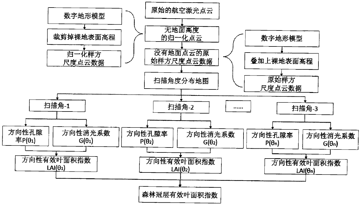
Embodiment Construction

[0069] The present invention is further explained by example below:

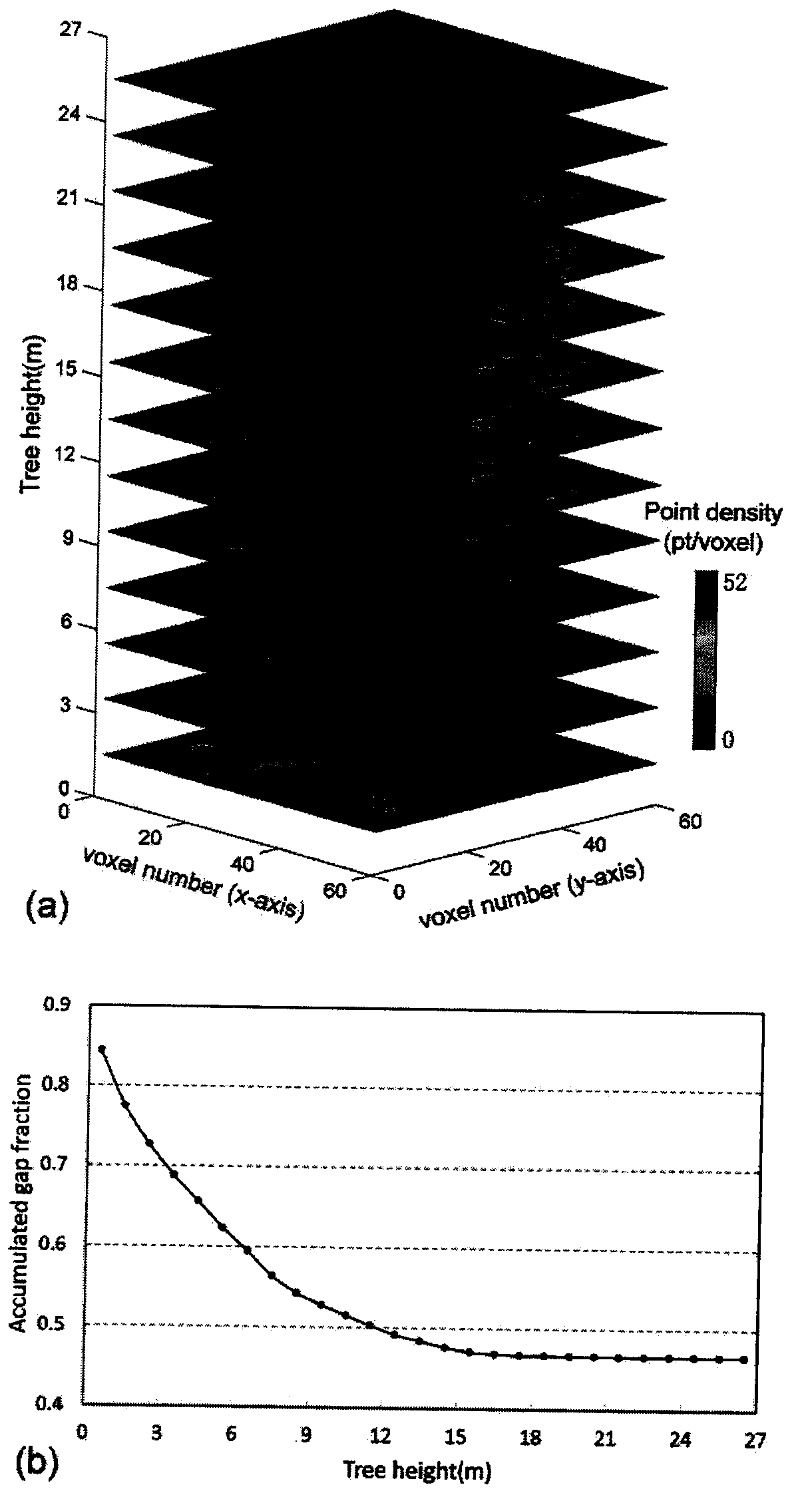
[0070] 1. Taking the Washington Botanical Garden next to the University of Washington in Seattle as the research object, it belongs to an urban heterogeneous park with more than 20,000 trees and about 4,000 different tree species. The terrain height ranges from 10m to 48.47m, and the effective leaf area index range is 0.19-6.48. In the research area, 27 sample squares with a radius of 30 meters were selected and divided into three groups according to the density: high density, medium density, and low density. Figure 7 As shown, Table 1 is the sampling information.

[0071] 2. During the time period from 2008-09-08 to 2009-09-15, stand at the center of the sample plots, use a fisheye camera to take hemispherical photos of 27 sample plots, and use high-precision GPS to record the set coordinates of the center points, Calculate the effective leaf area index and compare it with the effective leaf area index o...


PUM


Abstract

The invention provides a method for utilizing an aviation laser point cloud to calculate an effective leaf area index, and belongs to the research field of a forest canopy structure parameter obtaining method. The method comprises the steps of: obtaining and preprocessing three-dimensional laser point cloud data of a vegetation canopy; obtaining quadrat scale point cloud data having no ground point cloud data but having a ground height by means of a digital landform model; carrying out three-dimensional meshing on the point cloud data; under different scanning angles, respectively obtaining directional porosities directional extinction coefficients and directional effective leaf area indexes; and according to the effective leaf area index obtained under each scanning angle and the weight of the angle, obtaining the forest canopy effective leaf area index. Compared with other leaf area index calculating methods, the influences of scanning angle information on the directional porosities, the extinction coefficients and the effective leaf area indexes are fully considered; the canopy structure and the radiation characteristics are not destroyed, and the method is objective, effective and precise; in addition, the method for extracting a three-dimensional structure and biophysical diversity information from laser radar data is further developed.

Description

1. Technical field [0001] The present invention provides a method for extracting forest directional porosity, extinction coefficient and effective leaf area index by using aerial laser radar scanning data, focusing on the influence of different scanning angles on the extraction of these parameters, belonging to forest canopy structure parameters The field of study for the acquisition method. 2. Background technology [0002] LAI is one of the most critical factors for different ecological process models and bidirectional albedo distribution function models. Bell's law is the theoretical basis for the algorithm of extracting effective leaf area index, no matter for ground measured data or remote sensing data. Bell's law quantifies the attenuation of light as it penetrates a forest canopy with non-random leaf distribution. It is defined by the following formula: [0003] ln(P(θ))=-G(θ)L e / cos(θ)(1) [0004] θ is the zenith angle of the incident sunlight, Le is the effect...

Claims


Application Information

Patent Timeline
Patent Type & Authority Applications(China)
IPC IPC(8): G01B11/28
CPCG01B11/28
Inventor 郑光马利霞何维卢晓曼张乾路璐
Owner NANJING UNIV
Why Eureka
Try Eureka